Englefeld, Saskatchewan
| Englefeld | |
|---|---|
| Village | |
|
Main Street | |
  Englefeld  Englefeld Location of Englefeld in Saskatchewan | |
| Coordinates: 52°10′08″N 104°39′43″W / 52.169°N 104.662°W | |
| Country | Canada |
| Province | Saskatchewan |
| Region | Saskatchewan |
| Census division | 15 |
| Rural Municipality | St. Peter No. 369 |
| Post office Founded | February 1, 1907 |
| Incorporated (Village) | June 13, 1916 |
| Government | |
| • Mayor | Darrell Athmer |
| • Administrator | Lani Rae Best |
| • Governing body | Englefeld Village Council |
| Area | |
| • Total | 0.65 km2 (0.25 sq mi) |
| Elevation | 559 m (1,834 ft) |
| Population (2011)[1] | |
| • Total | 247 |
| • Density | 380.7/km2 (986/sq mi) |
| Time zone | CST (UTC-6) |
| • Summer (DST) | CST (UTC-6) |
| Postal code | S0K 1N0 |
| Area code(s) | 306 / 639 |
| Highways |
.svg.png) Hwy 5 Hwy 5 |
| Website | Englefeld.ca |
| [2][3][4][5] | |
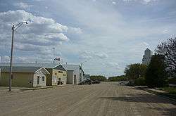
Englefeld (2011 population 247) is a village in St. Peter Rural Municipality No. 369, Saskatchewan, Canada, located thirty-two kilometres east of the city of Humboldt on Highway 5.
History
The community was named for Peter Engel, an abbot of Saint John's Abbey, located in Collegeville, Minnesota.[6] It is not known why Engel's name was spelled differently in the village's name. The surrounding area was settled by German Catholic immigrants in 1902-1903, and Englefeld was one of several communities within the tract known as St. Peter's Colony.[6]
Demographics
| Canada census – Englefeld, Saskatchewan community profile | |||
|---|---|---|---|
| 2011 | 2006 | ||
| Population: | 247 (8.8%% from 2006) | 227 (-2.8% from 2001) | |
| Land area: | 0.65 km2 (0.25 sq mi) | 0.65 km2 (0.25 sq mi) | |
| Population density: | 380.7/km2 (986/sq mi) | 349.9/km2 (906/sq mi) | |
| Median age: | 36.6 (M: 37.2, F: 35.5) | 37.5 (M: 35.1, F: 40.8) | |
| Total private dwellings: | 105 | 102 | |
| Median household income: | $Not Available | $Not Available | |
| References: 2011[7] 2006[8] | |||
Economy
Arts and culture
Hog Fest - The Englefeld Hog Fest was originally organized by Father Florian Renneberg in 1972.[9] The 40th annual fundraising event brought in 1270 people over July long weekend (July 1–3, 2011) which included Canada day fireworks, carnival/farmers market festivities, culminating in a feast with 16 smoked pigs, and closing out with a pancake breakfast.[9] As part of the 25th Hog Fest (celebrated in 1996) a 7 ft tall (17 ft long) fiberglass pig was erected on top of the Koenders Manufacturing building located in Englefeld along Highway 5.
See also
References
- ↑ "2011 Community Profiles". Statistics Canada. Government of Canada. Retrieved 2014-08-21.
- ↑ National Archives, Archivia Net. "Post Offices and Postmasters". Retrieved 2014-08-21.
- ↑ Government of Saskatchewan, MRD Home. "Municipal Directory System". Retrieved 2014-08-21.
- ↑ Canadian Textiles Institute. (2005), CTI Determine your provincial constituency
- ↑ Commissioner of Canada Elections, Chief Electoral Officer of Canada (2005), Elections Canada On-line
- 1 2 McLennan, David (2008), Our Town: Saskatchewan Communities from Abbey to Zenon Park, Regina, Saskatchewan: Canadian Plains Research Center, University of Regina, pp. 115–116, ISBN 978-0-88977-209-0
- ↑ "2011 Community Profiles". Canada 2011 Census. Statistics Canada. July 5, 2013. Retrieved 2009-02-24.
- ↑ "2006 Community Profiles". Canada 2006 Census. Statistics Canada. March 30, 2011. Retrieved 2009-02-24.
- 1 2 Solomon, Keith. "40th annual Hogfest exceeds all expectations". Local News. Humboldt Journal. Retrieved 16 October 2011.
External links
- Municipal Directory Saskatchewan - Village of Englefeld
- Saskatchewan Gen Web - One Room School Project
- Saskatchewan Gen Web Region
- Online Historical Map Digitization Project
- GeoNames Query
- Fields of prosperity : a history of Englefeld 1903-1987
 |
Naicam | | ||
| St. Gregor |  |
Watson | ||
| ||||
 | ||||
| Romance |


 Subdivisions of Saskatchewan Subdivisions of Saskatchewan | |
|---|---|
| Subdivisions | |
| Communities | |
| Cities | |
| Topics |
|
| |


Coordinates: 52°10′08″N 104°39′43″W / 52.169°N 104.662°W