Engyō-ji
| Shoshazan Engyō-ji | |
|---|---|
|
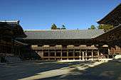
One of the main buildings in the Shoshazan Engyoji Temple complex. | |
| Basic information | |
| Location | 2968, Shosha, Himeji, Hyogo 671-2201 |
| Affiliation | Tendai |
| Country | Japan |
| Website | http://www.shosha.or.jp/ |
| Architectural description | |
| Founder | Shoku |
| Completed | 966 |
The Shoshazan Engyō-ji (書寫山圓教寺) is a temple of the Tendai sect in Himeji, Hyōgo, Japan. It was founded by Shoku Shonin in 966.
The complex of buildings is at the top of Mt Shosha approximately 25 minutes by bus from Himeji Station. The mountain summit can be reached by either a one mile hiking trail or Mt. Shosha Ropeway, and is often visited by pilgrims. Scenes from The Last Samurai were filmed here.
The Kansai Kannon Pilgrimage No.27.
Building list
- Daikōdō - Important Cultural Property of Japan. It was rebuilt in Muromachi period.
- Jōgyōdō - Important Cultural Property of Japan. It was rebuilt in Muromachi period.
- Jikidō - Important Cultural Property of Japan. It was rebuilt in Muromachi period.
- Shōrō - Important Cultural Property of Japan. It was rebuilt in Kamakura period.
- Kongodō - Important Cultural Property of Japan. It was rebuilt in Muromachi period.
- Gohōdō - Important Cultural Property of Japan. It was rebuilt in 1559.
- Gohōdō haiden - It was rebuilt in 1589.
- Maniden - It was rebuilt in 1933.
- Yakushidō
- Daikokudō
- Hokkedō
- Kaizandō - Important Cultural Property of Japan. It was rebuilt in Edo period.
- Fudōdō
- Gyōjadō
- Monjudō
- Bentendō
- Juryōin - Important Cultural Property of Japan.
- Jumyōin - Kyakuden, Kuri and Karamon is Important Cultural Property of Japan.
- Myōkōin
- Zuikōin
- Sengakuin
- Jujiin
 Maniden
 Jikidō
 Shōrō
Shōrō Jyōgyōdō
See also
- For an explanation of terms concerning Japanese Buddhism, Japanese Buddhist art, and Japanese Buddhist temple architecture, see the Glossary of Japanese Buddhism.
External links
- Mt. Shosha - Engyoji (Japanese)
- Official Himeji tourism website in English
- Hyogo Tourism - Engyoji
| Wikimedia Commons has media related to Engyoji. |
34°53′28″N 134°39′29″E / 34.891139°N 134.658139°ECoordinates: 34°53′28″N 134°39′29″E / 34.891139°N 134.658139°E
This article is issued from Wikipedia - version of the 10/23/2016. The text is available under the Creative Commons Attribution/Share Alike but additional terms may apply for the media files.
