Epfendorf
| Epfendorf | ||
|---|---|---|
| ||
 Epfendorf | ||
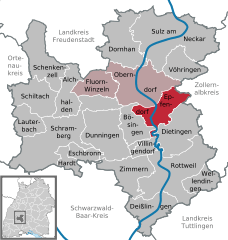
Location of Epfendorf within Rottweil district 
 | ||
| Coordinates: 48°14′58″N 08°35′54″E / 48.24944°N 8.59833°ECoordinates: 48°14′58″N 08°35′54″E / 48.24944°N 8.59833°E | ||
| Country | Germany | |
| State | Baden-Württemberg | |
| Admin. region | Freiburg | |
| District | Rottweil | |
| Government | ||
| • Mayor | Peter Boch | |
| Area | ||
| • Total | 29.71 km2 (11.47 sq mi) | |
| Population (2015-12-31)[1] | ||
| • Total | 3,280 | |
| • Density | 110/km2 (290/sq mi) | |
| Time zone | CET/CEST (UTC+1/+2) | |
| Postal codes | 78736 | |
| Dialling codes | 07404 | |
| Vehicle registration | RW | |
| Website | www.epfendorf.de | |
Epfendorf is a municipality in the district of Rottweil, in Baden-Württemberg, Germany. Epfendorf is located in the Upper Neckar valley between Oberndorf am Neckar and Rottweil.
Neighboring communities
The municipality borders to the north to the town of Oberndorf, to the east to the city of Rosenfeld in Zollernalbkreis, on the south to Dietingen and Villingendorf and on the west to Bösingen.
Outline
The community consists of the main town Epfendorf and the three districts Harthausen, Talhausen and Trichtingen.
The subsite Harthausen
History
The exact age of Epfendorf is not known, but the place was first documented in 994. Findings indicate a Roman settlement, a Roman road led to the Roman settlement in Waldmössingen. [2] On January 1, 1974, the municipality Harthausen was incorporated to Epfendorf. The incorporation of Trichtingen was on January 1, 1975.
Religions
The evangelical church Trichtingen (which also includes the main town Epfendorf ) belongs to the church district Sulz am Neckar and this belongs to the Evangelical-Lutheran Church in Württemberg.
Politics
The community belongs to the agreed management community with the city Oberndorf am Neckar.
Council
The local elections on 25 May 2014 led to the following conclusions:
- CDU / FW 47.2% (-4.7) 9 seats (-1)
- Free citizens 52.8% (+4.7) 10 seats (+/- 0)
Crest
Blazon : In red, a blue-lined golden ducal crown with Hermelinstulp.
Things
Epfendorf is located on the Neckar cycle path, which passes many sights.
Hiking and biking trails
Epfendorf has an extensive network of hiking trails. The Schlichem hiking trail ends in Epfendorf. Less experienced hikers can walk in summer with the Cyclo-shuttle from starting-point Tieringen in stages.[3]

Buildings
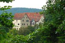
Not far from Harthausen is located in the woods the Lichtenegg Castle. It can not be visited because it is privately owned.

Transportation
Epfendorf is located on the Bundesstraße 14 and on the Gäubahn Stuttgart-Hattingen railway, however it is currently a station without passenger traffic.
Education
The municipality has two primary schools and a secondary school with Werkrealschule. All secondary schools are available in the nearby towns of Oberndorf and Rottweil.
References
- ↑ "Gemeinden in Deutschland nach Fläche, Bevölkerung und Postleitzahl am 30.09.2016". Statistisches Bundesamt (in German). 2016.
- ↑ Webseite der Gemeinde Epfendorf.
- ↑ Premiere. In: Schwarzwälder Bote. 28. April 2015.
