Esztergom County
| Esztergom County Comitatus Stringoniensis Esztergom vármegye Komitat Gran Ostrihomská župa | |||||
| County of the Kingdom of Hungary | |||||
| |||||
|
| |||||
 | |||||
| Capital | Esztergom 47°48′N 18°45′E / 47.800°N 18.750°ECoordinates: 47°48′N 18°45′E / 47.800°N 18.750°E | ||||
| History | |||||
| • | Established | 9th century | |||
| • | Treaty of Trianon | June 4, 1920 | |||
| Area | |||||
| • | 1910 | 1,077 km2 (416 sq mi) | |||
| Population | |||||
| • | 1910 | 90,800 | |||
| Density | 84.3 /km2 (218.4 /sq mi) | ||||
| Today part of | Slovakia, Hungary | ||||
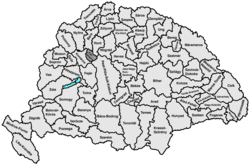
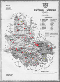
Esztergom County (Latin: comitatus Stringoniensis, Hungarian: Esztergom (vár)megye, Slovak: Ostrihomský komitát / Ostrihomská stolica / Ostrihomská župa, German: Graner Gespanschaft / Komitat Gran) was an administrative county of the Kingdom of Hungary. It's territory lies today in present-day southern Slovakia and northern Hungary on both sides of the Danube river.
Geography
Esztergom County shared borders with the counties Bars, Hont, Pest-Pilis-Solt-Kiskun and Komárom. Its territory comprised a 15 km strip to the west of the lower part of the Garam river and continued some 10 km south of the Danube river. Its area was 1077 km² around 1910.
Capitals
The capital of the county was the Esztergom Castle and the town of Esztergom, then from 1543 onwards – when the territory became part of the Ottoman Empire – the capital was outside the county (e. g. 1605–1663 in Érsekújvár), and finally from 1714 onwards the capital was the town of Esztergom.
History
A predecessor of the county existed as early as in the 9th century, when Esztergom (Slovak: Ostrihom) was one of the most important castles of Great Moravia. The Esztergom county as a comitatus arose at the end of the 10th century as one of the first comitatus of the Kingdom of Hungary. The county had a special status in that since 1270 its heads were at the same time the archbishops of Esztergom.
In the aftermath of World War I, the part of Esztergom county north of the Danube became part of newly formed Czechoslovakia, as recognized by the concerned states in 1920 by the Treaty of Trianon. The southern part remained in Hungary and merged with the southern part of Komárom county to form Komárom-Esztergom county.
Following the provisions of the First Vienna Award, the Czechoslovak part became again part of Hungary in November 1938. The old Esztergom county was recreated. After World War II, the Trianon borders were reestablished. In 1950, the name of the Hungarian part became Komárom county. This county was renamed to Komárom-Esztergom county in 1990. The part of the county north of the river Danube is now in Slovakia and is part of the Nitra region.
Demographics

In 1900, the county had a population of 87,651 people and was composed of the following linguistic communities:[1]
Total:
- Hungarian: 69,429 (79,2%)
- German: 9,995 (11,4%)
- Slovak: 7,491 (8,6%)
- Croatian: 61 (0,1%)
- Serbian: 15 (0,0%)
- Romanian: 7 (0,0%)
- Ruthenian: 1 (0,0%)
- Other or unknown: 652 (0,7%)
According to the census of 1900, the county was composed of the following religious communities:[2]
Total:
- Roman Catholic: 74,017 (84,4%)
- Calvinist: 9,829 (11,2%)
- Jewish: 2,974 (3,4%)
- Lutheran: 733 (0,8%)
- Greek Catholic: 54 (0,1%)
- Greek Orthodox: 33 (0,1%)
- Unitarian: 6 (0,0%)
- Other or unknown: 5 (0,0%)
Subdivisions
In the early 20th century, the subdivisions of Esztergom county were:
| Districts (járás) | |
|---|---|
| District | Capital |
| Esztergom | Esztergom |
| Párkány | Muzsla (present-day Mužla) until 1908, after Párkány (present-day Štúrovo) |
| Urban districts (rendezett tanácsú város) | |
| Esztergom | |
Štúrovo and Mužla are now in Slovakia.
- ↑ "KlimoTheca :: Könyvtár". Kt.lib.pte.hu. Retrieved 2012-12-06.
- ↑ "KlimoTheca :: Könyvtár". Kt.lib.pte.hu. Retrieved 2012-12-06.

