Falstone railway station
| Falstone | |
|---|---|
|
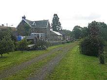
Station building in 2009. | |
| Location | |
| Place | Falstone |
| Area | Northumberland |
| Grid reference | NY726874 |
| Operations | |
| Original company | Border Counties Railway |
| Pre-grouping | North British Railway |
| Post-grouping |
London and North Eastern Railway North Eastern Region of British Railways |
| Platforms | 1 |
| History | |
| 2 September 1861 | Station opened |
| 15 October 1956 | Station closed to passengers |
| 1 September 1958 | Station closed to freight |
| Disused railway stations in the United Kingdom | |
|
Closed railway stations in Britain A B C D–F G H–J K–L M–O P–R S T–V W–Z | |
|
| |
| Border Counties Railway | |||||||||||||||||||||||||||||||||||||||||||||||||||||||||||||||||||||||||||||||||||||||||||||||||||||||||||||||||||||||||||||||||||||||||||||||||||||||||||||||||||||||||||||||||||||||||||||||||||||||||||||
|---|---|---|---|---|---|---|---|---|---|---|---|---|---|---|---|---|---|---|---|---|---|---|---|---|---|---|---|---|---|---|---|---|---|---|---|---|---|---|---|---|---|---|---|---|---|---|---|---|---|---|---|---|---|---|---|---|---|---|---|---|---|---|---|---|---|---|---|---|---|---|---|---|---|---|---|---|---|---|---|---|---|---|---|---|---|---|---|---|---|---|---|---|---|---|---|---|---|---|---|---|---|---|---|---|---|---|---|---|---|---|---|---|---|---|---|---|---|---|---|---|---|---|---|---|---|---|---|---|---|---|---|---|---|---|---|---|---|---|---|---|---|---|---|---|---|---|---|---|---|---|---|---|---|---|---|---|---|---|---|---|---|---|---|---|---|---|---|---|---|---|---|---|---|---|---|---|---|---|---|---|---|---|---|---|---|---|---|---|---|---|---|---|---|---|---|---|---|---|---|---|---|---|---|---|---|
| |||||||||||||||||||||||||||||||||||||||||||||||||||||||||||||||||||||||||||||||||||||||||||||||||||||||||||||||||||||||||||||||||||||||||||||||||||||||||||||||||||||||||||||||||||||||||||||||||||||||||||||
Legend | |||||||||||||||||||||||||||||||||||||||||||||||||||||||||||||||||||||||||||||||||||||||||||||||||||||||||||||||||||||||||||||||||||||||||||||||||||||||||||||||||||||||||||||||||||||||||||||||||||||||||||||
| |||||||||||||||||||||||||||||||||||||||||||||||||||||||||||||||||||||||||||||||||||||||||||||||||||||||||||||||||||||||||||||||||||||||||||||||||||||||||||||||||||||||||||||||||||||||||||||||||||||||||||||
Falstone railway station is a former railway station that served the hamlet of Falstone, in Northumberland, England.
History
The station was on the Border Counties Railway which linked the Newcastle and Carlisle Railway, near Hexham, with the Border Union Railway at Riccarton Junction. The first section of the route was opened between Hexham and Chollerford in 1858, the remainder opening in 1862. The line was closed to passengers by British Railways in 1956.
The station had a single platform and a stone built station building[1] both of which survived the line's closure. The station building is residential accommodation and offices.
| Preceding station | Disused railways | Following station | ||
|---|---|---|---|---|
| Plashetts | LNER Border Counties Railway |
Thorneyburn | ||
References
External links
Coordinates: 55°10′45″N 2°25′54″W / 55.1791°N 2.4317°W
This article is issued from Wikipedia - version of the 2/9/2016. The text is available under the Creative Commons Attribution/Share Alike but additional terms may apply for the media files.