Farnhill
| Farnhill | |
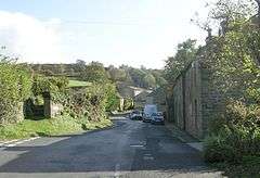 Main Street, Farnhill |
|
 Farnhill |
|
| Population | 509 (2011)[1] |
|---|---|
| OS grid reference | SE005465 |
| Civil parish | Farnhill |
| District | Craven |
| Shire county | North Yorkshire |
| Region | Yorkshire and the Humber |
| Country | England |
| Sovereign state | United Kingdom |
| Post town | KEIGHLEY |
| Postcode district | BD20 |
| Police | North Yorkshire |
| Fire | North Yorkshire |
| Ambulance | Yorkshire |
| EU Parliament | Yorkshire and the Humber |
Coordinates: 53°54′53″N 1°59′38″W / 53.914650°N 1.993870°W
Farnhill is a village and civil parish in the Craven district of North Yorkshire, England.[2][3] It is situated near Sutton-in-Craven and about 4 miles (6.4 km) south-east of Skipton. Farnhill is also across the canal from Kildwick and there is a church in Kildwick. There is a primary school next to the church and Farnhill backs up on to the moors. There are around 500 people living in Farnhill.
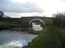
Bridge over the Leeds and Liverpool Canal at Farnhill
To the south of the village is Farnhill Hall, a fortified manor house, dating from the 15th century but much altered.
References
- ↑ "Parish population 2011". Neighbourhood Statistics. Office for National Statistics. Retrieved 25 July 2015.
- ↑ Ordnance Survey: Landranger map sheet 104 Leeds & Bradford (Harrogate & Ilkley) (Map). Ordnance Survey. 2014. ISBN 9780319231654.
- ↑ "Ordnance Survey: 1:50,000 Scale Gazetteer" (csv (download)). www.ordnancesurvey.co.uk. Ordnance Survey. 1 January 2016. Retrieved 18 February 2016.
External links
![]() Media related to Farnhill at Wikimedia Commons
Media related to Farnhill at Wikimedia Commons
This article is issued from Wikipedia - version of the 2/20/2016. The text is available under the Creative Commons Attribution/Share Alike but additional terms may apply for the media files.