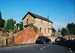
Garstang and Catterall railway station
| Garstang & Catterall | |
|---|---|
|
The former stationmaster's house in 2008 | |
| Location | |
| Place | Catterall |
| Area | Wyre |
| Coordinates | 53°53′20″N 2°44′52″W / 53.8890°N 2.7479°WCoordinates: 53°53′20″N 2°44′52″W / 53.8890°N 2.7479°W |
| Operations | |
| Original company | Lancaster and Preston Junction Railway |
| Pre-grouping | London and North Western Railway |
| Post-grouping | London, Midland and Scottish Railway |
| Platforms | 3 |
| History | |
| 26 June 1840 | Opened |
| 3 February 1969 | Closed |
| Disused railway stations in the United Kingdom | |
|
Closed railway stations in Britain A B C D–F G H–J K–L M–O P–R S T–V W–Z | |
|
| |
Garstang and Catterall railway station served as the interchange between the Garstang and Knot-End Railway and the London and North Western Railway, in Lancashire, England. The station was situated close to the village of Catterall, and adjacent to the Lancaster Canal. It is now opposite the Kenlis Arms Pub.
This station was on the Lancaster and Preston Junction Railway (now part of the West Coast Main Line) between Preston and Lancaster. It opened on 26 June 1840,[1] originally named Garstang Station.[2] It was the last of the stations between Preston and Lancaster to close, on 3 February 1969.[3]
References
- ↑ Butt, R.V.J. (1995), The Directory of Railway Stations, Patrick Stephens, Yeovil, ISBN 1-85260-508-1
- ↑ Suggitt, G. (2003, revised 2004) Lost Railways of Lancashire, Countryside Books, Newbury, ISBN 1-85306-801-2, p.28
- ↑ Welch, M.S. (2004) Lancashire Steam Finale, Runpast Publishing, Cheltenham, ISBN 1-870754-61-1, p.2
| Preceding station | Disused railways | Following station | ||
|---|---|---|---|---|
| Scorton | Lancaster and Preston Junction Railway | Brock | ||
| Garstang Town | Garstang and Knot-End Railway | Terminus | ||
This article is issued from Wikipedia - version of the 2/12/2016. The text is available under the Creative Commons Attribution/Share Alike but additional terms may apply for the media files.
