Georgia State Route 159
| ||||
|---|---|---|---|---|
| North Railroad Street, North Street | ||||
 | ||||
| Route information | ||||
| Maintained by GDOT | ||||
| Length: | 18.9 mi[1] (30.4 km) | |||
| Major junctions | ||||
| North end: |
  US 280 / SR 30 in Pitts US 280 / SR 30 in Pitts | |||
 I‑75 in Ashburn I‑75 in Ashburn | ||||
| South end: |
  US 41 / SR 7 in Ashburn US 41 / SR 7 in Ashburn | |||
| Location | ||||
| Counties: | Turner, Wilcox | |||
| Highway system | ||||
| ||||


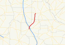
State Route 159 (SR 159) is a south–north state highway in the south-central part of the U.S. state of Georgia. Its routing is in portions of Turner and Wilcox counties.
Route description
SR 164 begins at an intersection with US 41/SR 7 in Ashburn It has an interchange with Interstate 75 (I-75) just before leaving town. It heads northeast until it meets a concurrency with SR 90. It heads north to the town of Pitts, where it meets its northern terminus, an intersection with US 280/SR 30.[1]
Major intersections
| County | Location | mi[1] | km | Destinations | Notes |
|---|---|---|---|---|---|
| Turner | Ashburn | 0.0 | 0.0 | US 41 / SR 7 | Southern terminus |
| 1.8 | 2.9 | I‑75 – Valdosta, Macon | I-75, exit 84 | ||
| | 10.1 | 16.3 |  SR 90 east (North Railroad Street) – Rebecca SR 90 east (North Railroad Street) – Rebecca | Southern end of SR 90 concurrency | |
| Turner–Wilcox county line | | 12.2 | 19.6 | SR 90 west – Cordele | Northern end of SR 90 concurrency |
| Wilcox | Pitts | 18.9 | 30.4 | US 280 / SR 30 (7th Avenue West) | Northern terminus |
1.000 mi = 1.609 km; 1.000 km = 0.621 mi
| |||||
See also
-
.svg.png) Georgia (U.S. state) portal
Georgia (U.S. state) portal -
 U.S. Roads portal
References
- 1 2 3 Google (June 10, 2013). "Route of SR 159" (Map). Google Maps. Google. Retrieved June 10, 2013.
External links
-
 Media related to Georgia State Route 159 at Wikimedia Commons
 - Georgia Roads (Routes 141 - 160)
This article is issued from Wikipedia - version of the 4/27/2016. The text is available under the Creative Commons Attribution/Share Alike but additional terms may apply for the media files.