Georgia State Route 33
| ||||
|---|---|---|---|---|
 | ||||
| Route information | ||||
| Maintained by GDOT | ||||
| Length: | 81.00 mi[1] (130.36 km) | |||
| Major junctions | ||||
| South end: |
  US 84 / SR 38 in Boston US 84 / SR 38 in Boston | |||
     US 319 / US 319 Bus. / SR 35 south of Moultrie US 319 / US 319 Bus. / SR 35 south of Moultrie US 319 / US 319 Bus. / SR 35 / SR 133 US 319 / US 319 Bus. / SR 35 / SR 133   US 82 / SR 112 / SR 520 in Sylvester US 82 / SR 112 / SR 520 in Sylvester | ||||
| North end: |
   US 41 / SR 7 / SR 33 Conn. south of Cordele US 41 / SR 7 / SR 33 Conn. south of Cordele | |||
| Location | ||||
| Counties: | Thomas, Brooks, Colquitt, Worth, Crisp | |||
| Highway system | ||||
| ||||


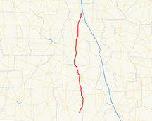
State Route 33 (SR 33) is an 81-mile-long (130 km) state highway that runs south-to-north through portions of Thomas, Brooks, Colquitt, Worth, and Crisp counties in the south-central part of the U.S. state of Georgia. The route runs from its southern terminus, an intersection with US 84/SR 38 in Boston, to its northern terminus, an intersection with US 41/SR 7 south of Cordele.
Route description
SR 33 begins at an intersection with US 84/SR 38 in Boston. The route travels north to Pavo. After a brief concurrency in Pavo with SR 122, SR 33 continues north. South of Moultrie, SR 33 begins a concurrency with US 319 Business. The two routes travel north, through downtown Moultrie. North of the city, US 319 Business departs, and after a brief concurrency with SR 133, the route continues north to Sylvester. In Sylvester, SR 33 has a brief concurrency with SR 112 before departing and continuing north to meet its northern terminus, an intersection with US 41/SR 7 south of Cordele.
History
Major intersections
| County | Location | mi | km | Destinations | Notes |
|---|---|---|---|---|---|
| Thomas | Boston | US 84 / SR 38 – Valdosta, Thomasville | Southern terminus | ||
| Thomas–Brooks county line | Pavo |  SR 122 east SR 122 east | Eastern end of SR 122 concurrency | ||
| Thomas | SR 122 west | Western end of SR 122 concurrency | |||
| |  SR 188 west SR 188 west | Eastern terminus of SR 188 | |||
| Colquitt | Moultrie | US 319 / SR 35 | |||
 SR 37 SR 37 | |||||
 SR 111 west SR 111 west | Eastern terminus of SR 111 | ||||
| US 319 / SR 35 / SR 133 south | Southern end of SR 133 concurrency | ||||
| | SR 133 north | Northern end of SR 133 concurrency | |||
| |  SR 270 west SR 270 west | Eastern terminus of SR 270 | |||
| Worth | Sylvester |  SR 256 south SR 256 south | Northern terminus of SR 256 | ||
| US 82 / SR 112 south / SR 520 | Southern end of SR 112 concurrency | ||||
| SR 112 north | Northern end of SR 112 concurrency | ||||
| |  SR 32 SR 32 | ||||
| Crisp | | US 41 / SR 7 / SR 33 Conn. | Northern terminus | ||
1.000 mi = 1.609 km; 1.000 km = 0.621 mi
| |||||
Bannered route
| |
|---|---|
| Location: | Cordele |
State Route 33 Connector (SR 33 Connector) is a short connector route near Cordele. SR 33 Connector connects the SR 33 mainline, as well as US 41/SR 7, with Interstate 75 (I-75), via Rockbridge Road.
See also
-
.svg.png) Georgia (U.S. state) portal
Georgia (U.S. state) portal -
 U.S. Roads portal
References
- ↑ Google (8 November 2012). "GA-33" (Map). Google Maps. Google. Retrieved 8 November 2012.
External links
-
 Media related to Georgia State Route 33 at Wikimedia Commons