Great South Bay

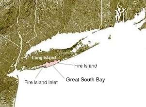
Great South Bay, actually a lagoon,[1] is situated between Long Island and Fire Island, in the State of New York. It is approximately 45 miles (72 km) long. It is protected from the Atlantic Ocean by Fire Island, a barrier island, as well as the eastern end of Jones Beach Island and Captree Island.
Robert Moses Causeway adjoins the Great South Bay Bridge, which leads to Robert Moses State Park.

The bay is accessible from the ocean through Fire Island Inlet, which lies between the western tip of Fire Island and the eastern tip of Jones Beach Island. The bay adjoins South Oyster Bay on its western end and Patchogue and Moriches bays at the east end.
History
In the early 17th century, European settlers first encountered the native Meroke tribes. Among the earliest British families were the Smith, Carman and Hewlett families.[2] Long Island's South Shore, which includes Lindenhurst, Babylon, Islip, Oakdale, Sayville, Bayport, Blue Point, Patchogue, Bellport, Shirley, and Mastic Beach. These towns are historic bay towns, with a rich history of clamming, fishing and boating.
Environmental concerns

The bay is under grave threat because with 400,000 septic tanks in Suffolk County, along with run off from lawn fertilizers and pesticides, the Eel grass beds, an important habitat for shellfish and finfish, have been decimated by massive algal blooms . At one time The Great South Bay produced over 50% of the hard shell clams eaten in the United State, with 6,500 clammers working in the bay. There is now 1% of the yield in 1976. An industry collapsed, and the South Shore communities suffered greatly. In 1976, 40% of the bay water was filtered by the clams themselves. Without clams to filter the water, the quality of the bay began to decline. The first brown tide was observed in 1985 and soon many bays and ponds in the area began seeing a variety of algal blooms—brown, rust, red, and blue-green.
In July 2013, The Great South Bay was covered with brown tide throughout, with the algae blocking the sunlight, damaging habitat and adversely affecting the fish and shellfish. The cell counts were over 1 million per liter in much of the bay, the one exception being The Breach and The New Inlet.
In the late nineteenth century Great South Bay provided many of the clams consumed throughout the region and even the country. The first oysters to be exported from the US to Europe came from Great South Bay. By the latter 20th century, a significant percentage of the habitat was lost and the clam population was dramatically reduced, devastating the neighboring communities that depended on it. In the 19th century thousands of baymen worked the waters of Great South Bay. Now, only a scant few can be seen.
The majority of these concerns could be alleviated due to the Great South Bay's new-found ability to begin flushing itself out.[3] Recently the largest storm on record since 1938, Hurricane Sandy, made land fall with devastating impact to Fire Island sea shores, including multiple breeches. The largest forming just south of Bellport, Long Island. This was formerly known as Old Inlet. Residents were concerned it would have effects on tidal increases and potential flooding, when in actuality it has allowed the bay to relieve some of its captive water, which has changed the salinity and nitrogen levels in the bay.[4] The Bay has, after roughly 75 years, begun flushing itself out which may improve the water condition within the bay.[5] Regulations set forth by the US Government National Wildlife Preserve, which has a seven-mile stretch of land (The Otis Pike Fire Island High Dune Wilderness) prohibit any unauthorized parties from performing any kind of man made changes, thus the inlet has remained open. There have been a number of ongoing public meeting discussing the future of the Inlet.[6] All the other breaches were closed by the Army Corps of Engineers. The Save the Great South Bay not-for-profit organization was formed in order to work towards better conservation of the water and its beachfronts.[7][8]
See also
References
- ↑ S. Goodbred, Jr; P. Locicero; V. Bonvento; S. Kolbe; S. Holsinger. "History of the Great South Bay estuary: Evidence for a catastrophic origin" (PDF). SUNY.com. Retrieved 2013-10-02.
- ↑ http://freepages.genealogy.rootsweb.com/~carman/hsarch/hsarch2.htm
- ↑ http://www.wired.com/geekmom/2013/01/fire-island-breach-helpful/
- ↑ http://savethegreatsouthbay.org/what-mother-nature-and-the-new-inlet-cant-do-a-bay-in-peril/2013/04/16/655/
- ↑ http://www.nps.gov/fiis/naturescience/post-hurricane-sandy-breaches.htm
- ↑ http://www.timesunion.com/business/press-releases/article/Public-Discussion-of-the-Fire-Island-Breach-at-4391069.php
- ↑ Will James (November 13, 2013). "On Long Island Coast, An Unexpected Gift From Hurricane Sandy". The Atlantic.
- ↑ Jason Atkinson (September 20, 2013). "Conservation's Radical Middle". Huffington Post.
External links
| Wikimedia Commons has media related to Great South Bay. |
- Back To Baysics - Great South Bay environmental awareness campaign
- Great South Bay Project
- Peconic Baykeepers The Waterkeeper Alliance Member for the Great South Bay
Coordinates: 40°41′25″N 73°06′07″W / 40.69028°N 73.10194°W