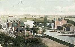
Grove Ferry and Upstreet railway station
| Grove Ferry and Upstreet | |
|---|---|
|
Grove Ferry Railway Station 1907 | |
| Location | |
| Place | Canterbury |
| Area | City of Canterbury |
| Grid reference | TR235632 |
| Operations | |
| Original company | South Eastern Railway |
| Pre-grouping | South Eastern and Chatham Railway |
| Post-grouping | Southern Railway |
| Platforms | 2 |
| History | |
| 13 April 1846 | Opened as Grove Ferry |
| 20 September 1954 | Renamed Grove Ferry and Upstreet |
| 30 April 1960 | Station closed to freight |
| 3 January 1966 | Station closed to passengers |
| Disused railway stations in the United Kingdom | |
|
Closed railway stations in Britain A B C D–F G H–J K–L M–O P–R S T–V W–Z | |
|
| |
Grove Ferry and Upstreet was a railway station in east Kent. It was opened by South Eastern Railway (SER), on the Ashford to Ramsgate (via Canterbury West) line between Sturry station and Minster station.
The buildings have been demolished and only a few traces remain of the platforms
History
Opened on 13 April 1846 this rural station was built to serve the village of Upstreet and the ferry crossing of the Great Stour until the 1960s when a bridge was built. The nearby "Grove Ferry Inn" owned the rights to the ferry and farmed lavender, creating a popular day trip destination up until the Second World War. Now part of the Grove Ferry Picnic Area.
The public Level Crossing and goods sidings leading to the ferry was operated from a small signalbox. The signal box closed many years ago and the level crossing is now operated by automated barriers. The broad steps leading to the footpath connecting the station to the village, although overgrown, can still be seen.
Goods traffic ceased on 30 April 1960 and the station was closed to passenger traffic on 3 January 1966 shortly before the introduction of a bus service over the new Grove Ferry Bridge, which would have undermined the low patronage.
Grove Ferry and Upstreet Station lives on in model form and is sometimes taken on tour by the Ashford Model Railway Club.[1]
| Preceding station | Disused railways | Following station | ||
|---|---|---|---|---|
| Chislet Colliery Halt | British Rail Southern Region Ashford to Ramsgate (via Canterbury West) line |
Minster | ||
References
- ↑ "Layouts - Grove Ferry & Upstreet". Ashford Model Railway Club. 2009. Retrieved 30 December 2009. Archived 30 December 2009 at WebCite
Coordinates: 51°19′27″N 1°12′24″E / 51.32408°N 1.20675°E
