Haverhill Corner Historic District
|
Haverhill Corner Historic District | |
 | |
  | |
| Location | NH 10 from N. Piedmont to bisection of NH 25 and Court St., Haverhill, New Hampshire |
|---|---|
| Coordinates | 44°1′53″N 72°3′51″W / 44.03139°N 72.06417°WCoordinates: 44°1′53″N 72°3′51″W / 44.03139°N 72.06417°W |
| Area | 544 acres (220 ha) |
| Architectural style | Greek Revival, Late Victorian, Federal |
| NRHP Reference # | 87001415[1] |
| Added to NRHP | August 27, 1987 |
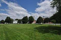
The Haverhill Corner Historic District encompasses the early civic center of Haverhill, New Hampshire, United States. The district is focused on the junction of New Hampshire Route 10 and Court Street, which was historically a major through route. Court Street is flanked at the junction by a pair of large grassy common areas which are bounded by School Street and Route 10. Buildings, predominantly Federal in character and built in the late 18th and early 19th centuries, are arrayed around these commons, and historic buildings line Route 10 and Court Street for a short distance away from the commons. Prominent buildings in the district include the 1827 Federal-style First Congregational Church, the 1840 former courthouse that now houses the public library and local historical society, and the Romanesque Revival 1897 Haverhill Academy Junior High School building. The area declined in importance after the railroad bypassed it, resulting in the gradual relocation of civic functions to the Woodsville area.[2]
The district was listed on the National Register of Historic Places in 1987.[1]
See also
References
- 1 2 National Park Service (2010-07-09). "National Register Information System". National Register of Historic Places. National Park Service.
- ↑ "NRHP nomination for Haverhill Corner Historic District" (PDF). National Park Service. Retrieved 2014-04-01.
| Topics |  | |
|---|---|---|
| Lists by county | ||
| Other lists | ||
| ||