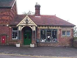
Heathfield (Sussex) railway station
| Heathfield | |
|---|---|
 | |
| Location | |
| Place | Heathfield |
| Area | Wealden |
| Grid reference | TQ579213 |
| Operations | |
| Pre-grouping | London, Brighton and South Coast Railway |
| Post-grouping |
Southern Railway Southern Region of British Railways |
| Platforms | 2 |
| History | |
| 5 April 1880[1] | Station opened |
| 14 June 1965 | Station closed to passengers |
| 26 April 1968 | Station closed to freight |
| Disused railway stations in the United Kingdom | |
|
Closed railway stations in Britain A B C D–F G H–J K–L M–O P–R S T–V W–Z | |
|
| |
Heathfield railway station was on the Cuckoo Line between Horam and Mayfield, serving the market town of Heathfield.
It was built in 1880 by London, Brighton and South Coast Railway on the line extension from Hailsham to Eridge.
It was closed for passenger trains in 1965 but freight trains served the goods yard until 1968 when it was abandoned.
| Preceding station | Disused railways | Following station | ||
|---|---|---|---|---|
| Mayfield | British Rail Southern Region Cuckoo Line |
Horam | ||
Gas supply
In 1896 the LB&SCR drilled for water at the north end of the station. Natural gas was discovered at 312 feet. In 1898 and 1899 Charles Dawson gave several demonstrations with the gas and the railway began to use the gas to light the station. The natural gas was used for this purpose until February 1934 when the station was converted to town gas. The well was sealed in 1963.
Present day
An industrial estate and car park now occupy much of the station site to the south-east. Above them at road level (Station Approach), the booking office still survives as a shop and café.
As part of the extension to the Cuckoo Trail, the 265 yard long Heathfield tunnel north of the station was restored and reopened in 2002. There is now a lit footpath running through it and a skateboarding ramp just outside the south portal.
References
- The Cuckoo Line, A.C. Elliot - Wild Swan Publications
- The Historic Gas Times. June 2013. The Institution of Gas Engineers and Managers
Coordinates: 50°58′11″N 0°15′00″E / 50.9697°N 0.2500°E