Hoeilaart
| Hoeilaart | |||
|---|---|---|---|
| Municipality | |||
|
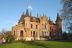
Hoeilaart Town Hall | |||
| |||
 Hoeilaart Location in Belgium | |||
|
Location of Hoeilaart in Flemish Brabant  | |||
| Coordinates: 50°46′N 04°28′E / 50.767°N 4.467°ECoordinates: 50°46′N 04°28′E / 50.767°N 4.467°E | |||
| Country | Belgium | ||
| Community | Flemish Community | ||
| Region | Flemish Region | ||
| Province | Flemish Brabant | ||
| Arrondissement | Halle-Vilvoorde | ||
| Government | |||
| • Mayor | Tim Vandenput (VLD) | ||
| • Governing party/ies | VLD, PW | ||
| Area | |||
| • Total | 20.43 km2 (7.89 sq mi) | ||
| Population (1 January 2016)[1] | |||
| • Total | 10,915 | ||
| • Density | 530/km2 (1,400/sq mi) | ||
| Postal codes | 1560 | ||
| Area codes | 02 | ||
| Website | www.hoeilaart.be | ||
Hoeilaart (Dutch pronunciation: [ˈɦui̯laːrt]) is a municipality in the province of Flemish Brabant, Belgium. The name Hoeilaart is of Gallic-Celtic origin, coming from "Ho-Lar," meaning a high clearing in the woods. Residents are called Hoeilanders or Doenders. The municipality only comprises the town of Hoeilaart proper. On January 1, 2006, Hoeilaart had a total population of 10,074. The total area is 20.43 km² which gives a population density of 493 inhabitants per km². Hoeilaart also sometimes called "The Glass Village" because of the greenhouse grape cultivation that once took place.
The official language is Dutch. Local minorities consist of nationals from many European union-countries, USA and Canada, and from French-speakers.
Attractions
- Forest Museum Jan van Ruusbroec (in the Sonian Forest)
- Neo-Romanesque Church dating from 1870-1874
- Kasteel de Man (town hall)
- "Serristenvillas" from the 1920s
- Smeyberghoeve
- The old millhouse of the Groenendael Priory
- Old tram station of Hoeilaart with Nero statue
Famous inhabitants
- Jan van Ruusbroec (1291-1381), one of the greatest mystics of the southern Netherlands.
- Armand Pien, weather forecaster on Flemish TV
- Marc Sleen, comics artist, author of Nero
- Jaak Pijpen, lawyer, politician
- Walter Baele
References
- ↑ Population per municipality as of 1 January 2016 (XLS; 397 KB)
External links
-
 Media related to Hoeilaart at Wikimedia Commons
 - Official website - Only available in Dutch
 |
Watermael-Boitsfort (BRU) |  | ||
| Sint-Genesius-Rode | |
Overijse | ||
| ||||
| | ||||
| Waterloo (WBR) | La Hulpe (WBR) |


