Howsham Hall

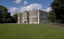
Howsham Hall is a 28,336 square feet (2,632.5 m2) grade I listed Jacobean stately home in Howsham, North Yorkshire, England.[1]
It is built in two storeys of limestone ashlar to a U-shaped plan with a 7-bay frontage. [2]
History
In the early 16th century the Howsham estate belonged to nearby Kirkham Priory and following the Dissolution of the Monasteries under Henry VIII was granted to Thomas Manners, 1st Earl of Rutland around 1540. His great-grandson sold it to Thomas Bamburgh. The present Hall was built in about 1610 on the site of a previous manor house, using stone from the priory, by Sir William Bamburgh, whose coat of arms, with those of his wife Mary Forthe, is above the main entrance. The cellar is Norman and the main part of the house is Jacobean. However the structure of the building has since been altered over the years. Sir William was High Sheriff of Yorkshire in 1607–08.
In 1709, the house having passed by marriage to the Wentworth family, Sir John Wentworth added the east front.[1]
Having passed again by marriage to the Cholmeley family of Whitby Abbey, the house was remodelled in about 1775 for Nathaniel Cholmeley, possibly by John Carr. There is a Georgian brick extension at the back of the house and some of the windows have been altered so they have larger panes in the Georgian style. The parkland was laid out by Capability Brown in the 1770s for the Cholmeley family. In the grounds are three Giant Sequoia trees arranged in a triangle. These were given to a limited number of country estates in the seventeenth century. Sequoias were unknown to European horticulture till the middle of the 19th century, post the California goldrush.
The estate passed (once again by marriage) to the Strickland family in the 19th century. They sold the estate and its contents in 1948; in the 1950s, it was bought by John Knock and converted into a boy’s preparatory school.[3]
The hall and its estate are currently up for sale as a private house for £5,000,000.[4] The old gates for the estate are several miles away towards York and have been recently restored.
Curse of Kirkham
When Kirkham Priory was demolished following the Protestant Reformation and the stones, timbers and other material were taken away by the Bamburghs and used in the construction of Howsham Hall, it was considered sacrilege at the time. It was said that true happiness would never come to the family or its successors and that a curse was placed on Howsham Hall and the people that owned it whereby "All male heirs of the estate would perish". The Bamburugh family died out because of the lack of male heirs, the Wentworth intermarried with the Bamburghs and they too became extinct. The next owners, the Cholmeleys, also became extinct and the Stricklands have only one female member of the family left. The last family to buy the house were the Knocks, and the curse continues, as Anthony Knock died after losing a battle with cancer in 2004.[5]
Howsham Hall School
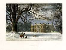
 Engraving of Howsham Hall | |
| Motto |
Potentes Virtute ("Strength In Courage") |
|---|---|
| Established | 1958 |
| Closed | 2007 |
| Type | Preparatory school |
| Gender | Coeducational |
Howsham Hall was bought in 1956 by John Knock. It had been due to be demolished by the council, but in 1958 it opened as an independent boys' school. In 1993 the school introduced both girls and day pupils increasing school numbers to around 60. The school was closed on 6 July 2007 at the end of the Summer Term due to dwindling pupil numbers.[5]
The School
The subjects that the school taught were French, Maths, English, Latin, Poetry, History, Debating, Singing, R.E., Ancient History, Hand Writing, Art, Geography, I.T. and Science. Drama was also offered to pupils up until year 7. The school also offered music lessons. The total number of pupils was approximately 60 which meant that each year had around 10 pupils in each year group. This meant that class sizes were small as well. Howsham Hall was a Roman Catholic school and had a morning and evening service every weekday and mass on Sunday. In the Autumn and Spring terms boys played rugby, with the school fielding a 1st XI and an U11s team; while the girls had ballet, aerobics or needlework classes. Pupils also did cross country on Mondays and Thursdays culminating a 7 mile run at the end of the spring term called the "championship" an inter house competition. In the summer term boys did cricket with the school fielding 2 teams senior and junior and the girls did rounders. Horse riding was also offered on Tuesday afternoons and Swimming was done up until year 7 (Form 2) on Friday morning at Pickering. The school also offered occasional canoeing, shooting and sailing.
Allegations of abuse
In 1998 allegations of abuse were brought against the school by a former pupil.[6][7] The allegations included the beating of pupils with straps, pupils being made to stand in cold baths for hours, public humiliation of bed-wetters and censorship of letters home,[6] however none of these allegations were proven and were subsequently dropped after numerous testimonials from other former pupils. The Knocks were renowned for their "little black book" which would record a pupil's name for future punishment and be waved from the touchline with the word "....you're in the book" if the player was not seen to be playing well enough.
References
- 1 2 "Howsham Hall". British Listed Buildings. Retrieved 13 February 2013.
- ↑ "Howsham Conservation Area Appraisal" (PDF). Ryedale District Council. Retrieved 13 February 2012.
- ↑ Howsham Hall website http://www.howshamhall.com/#/about/4547412656
- ↑ "Property for sale - Howsham, North Yorkshire, YO60". Retrieved 26 September 2014.
- 1 2 "Howsham Hall prepares for closure after 50 years". York Press. Newsquest Media Group. 13 January 2007. Retrieved 11 February 2009.
- 1 2 Hamer, Rupert (17 May 1997). "Badge Of Brutality". Sunday Mirror. MGN LTD. Retrieved 8 August 2009.
- ↑ "Private school accused of abuse". The Evening Press. Newsquest Media Group. 7 May 1998. Retrieved 8 August 2009.
External links
Coordinates: 54°03′33″N 0°52′48″W / 54.05916°N 0.88006°W