Huggins (Martian crater)
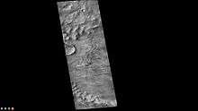
Huggins Crater, as seen by CTX camera (on Mars Reconnaissance Orbiter).
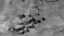
Dunes and dust devil tracks on floor of Huggins Crater, as seen by CTX camera (on Mars Reconnaissance Orbiter). Dark streaks on dunes are dust devil tracks. Note: this is an enlargement of the previous image of Huggins Crater.
Huggins Crater is an impact crater in the Eridania quadrangle of Mars, located at 49.4°S latitude and 204.4°W longitude. It is 90.0 km in diameter and was named after William Huggins, and the name was approved in 1973 by the International Astronomical Union (IAU) Working Group for Planetary System Nomenclature (WGPSN).[1] Dust devil tracks can be seen on dunes in one of the pictures below.
See also
References
- ↑ "Gazetteer of Planetary Nomenclature | Huggins". usgs.gov. International Astronomical Union. Retrieved 4 March 2015.
This article is issued from Wikipedia - version of the 8/30/2015. The text is available under the Creative Commons Attribution/Share Alike but additional terms may apply for the media files.