Interstate 69C
| |
|---|---|
 | |
| Route information | |
| Maintained by TxDOT | |
| Existed: | May 30, 2013 – present |
| Central Rio Grande Valley segment | |
| Length: | 18 mi[1] (29 km) |
| South end: |
   I-2 / US 83 / US 281 in Pharr I-2 / US 83 / US 281 in Pharr |
| North end: |
   US 281 / Bus. US 281 near Edinburg US 281 / Bus. US 281 near Edinburg |
| Unbuilt Section | |
| South end: |
US 281 south / Bus. US 281 near Edinburg |
| North end: |
   I-69W / US 59 / US 281 north / I-37 in George West I-69W / US 59 / US 281 north / I-37 in George West |
| Highway system | |

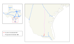
Interstate 69C (I-69C) is a south–north freeway running through South Texas. Once complete the freeway (with connections to Mexican Federal Highway 97) will begin at Interstate 2/U.S. Highway 83 in Pharr and head northward before terminating at I-69W/US 59 in George West near I-37. For its entire length, I-69C shares its alignment with US 281.
History


The Federal Highway Administration approved the designation for the South Rio Grande Valley Segment on May 24, 2013,[2] and the Texas Transportation Commission followed suit on May 30, 2013.[3] This action finalized the designations of not only I-69C, but also of the sections of Interstate 69E (I-69E) from Brownsville north to north of Raymondville, and also Interstate 2 (I-2) which is a 46.8-mile (75.3 km) freeway connecting with I-69C and I-69E in Mission and Harlingen.[2] These approvals added over 100 miles (160 km) to the Interstate Highway System in the Rio Grande Valley.[4] The signage was installed in summer 2013.[5]
As of June 2013, the cluster consisting of the recently designated portions of I-69C, I-69E, and I-2 in the Rio Grande Valley is not connected to the national Interstate network. This situation is slated to be remedied by scheduled projects to complete I-69E along US 77 between Raymondville and Robstown, and to complete the southern end of the previously signed portion of the I-69 corridor connecting with I-37 west of Corpus Christi. Environmental Protection Agency approval for the upgrade of the US 77 alignment to Interstate standards, including bypasses of the towns along the 91-mile (146 km) routing, was obtained through a Finding of No Significant Impact statement issued on July 13, 2012;[6] funding for the various projects to effect the upgrades is slated to become available after 2015.[7] During August 2014, exit numbering began on the south most segment in Edinburg.
Exit list
The entire route is in Hidalgo County.
| Location | mi | km | Exit[8] | Destinations | Notes | |
|---|---|---|---|---|---|---|
| Pharr | 0.0 | 0.0 | 1 | I-2 / US 83 – McAllen, Harlingen | signed as exits 1A (west) and 1B (east); I-2 exits 146A-B | |
| 0.8 | 1.3 | 1C |  US 281 south / SH 495 – Pharr US 281 south / SH 495 – Pharr | South end of US 281 overlap; southbound exit and northbound entrance | ||
| 1.2 | 1.9 | 1D | Sioux Road | Southbound exit and northbound entrance | ||
| 1.5 | 2.4 | 1E |  FM 3461 (Nolana Loop) FM 3461 (Nolana Loop) | |||
| Pharr–Edinburg line | 2.5 | 4.0 | 2 |  Bus. US 281 north / Owassa Road – Edinburg Bus. US 281 north / Owassa Road – Edinburg | Access to Doctors Hospital at Renaissance | |
| Edinburg | 3.2 | 5.1 | 3 | Trenton Road | Access to Cornerstone Regional Hospital and Edinburg Regional Medical Center | |
| 4.2 | 6.8 | 4 | Canton Road / Veterans Boulevard | |||
| 5.3 | 8.5 | 5 | Freddy Gonzalez Drive / Sprague Street | |||
| 6.6 | 10.6 | 6 |  SH 107 (University Drive) SH 107 (University Drive) | |||
| 7.1 | 11.4 | 7 |  FM 2128 / Schunior Road / Richardson Road / Chapin Road FM 2128 / Schunior Road / Richardson Road / Chapin Road | |||
| 8.2 | 13.2 | 8 | Russell Road / Rogers Road | |||
| 8.6 | 13.8 | 9 |  FM 1925 (Monte Cristo Road) FM 1925 (Monte Cristo Road) | |||
| 13.5 | 21.7 | 10 | Bus. US 281 south – Edinburg | Southbound exit and northbound entrance | ||
| 11 | Davis Drive / Ramseyer Road | |||||
| 12 |  FM 2812 FM 2812 | |||||
 FM 162 (El Cibolo Road) FM 162 (El Cibolo Road) | ||||||
 FM 490 FM 490 | ||||||
1.000 mi = 1.609 km; 1.000 km = 0.621 mi
| ||||||
See also
-
 Texas portal
 -
 U.S. Roads portal
References
- ↑ Transportation Planning and Programming Division (n.d.). "Interstate Highway No. 69-C". Highway Designation Files. Texas Department of Transportation. Retrieved September 3, 2013.
- 1 2 Staff (May 30, 2013). "Interstate 69 Comes to Texarkana and the Valley" (Press release). Alliance for I-69 Texas. Retrieved July 17, 2013.
- ↑ Nino, Mark (May 31, 2013). "Texas Transportation Commission Approves Interstate 69 System". Brownsville, TX: KVEO-TV. Retrieved July 17, 2013.
- ↑ Taylor, Steve (May 30, 2013). "Over 100 Miles of Valley Highways To Be Designated Interstate". Rio Grande Guardian. McAllen, TX. Retrieved July 17, 2013.
- ↑ Janes, Jared (July 15, 2013). "Valley's I-69 signage the latest stop along superhighway dream". The Monitor. Retrieved July 17, 2013.
- ↑ Staff (July 13, 2012). "Agency Gives US 77 Upgrades Final Environmental Clearance" (Press release). Alliance for I-69 Texas. Retrieved July 17, 2013.
- ↑ Clark, Steve (August 8, 2011). "Interstate Link to Valley Moves Closer to Reality, Official Says". Brownsville Herald. Retrieved July 17, 2013.
- ↑ Texas Department of Transportation, plans of proposed highway maintenance contract (1.58 GB ZIP file), December 2014
External links
 Media related to Interstate 69 in Texas at Wikimedia Commons
 | ||
| ||