IB-28 highway (Serbia)
| ||||
|---|---|---|---|---|
|
Државни пут IБ реда 28 Državni put IB reda 28 | ||||
 | ||||
| Route information | ||||
|
Part of | ||||
| Maintained by JP "Putevi Srbije" | ||||
| Length: | 172.486 km (107.178 mi) | |||
| Major junctions | ||||
| From: |
Mali Zvornik | |||
| To: |
Serbia-Bosnia and Herzegovina border at Kotroman | |||
| Location | ||||
| Districts: | Mačva, Zlatibor | |||
| Highway system | ||||
| ||||
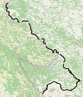
National/State Road 28 is an IB-class road in western Serbia, connecting Mali Zvornik with Bosnia and Herzegovina at Kotroman. It is located in Šumadija and Western Serbia.[1]
Before the new road categorization regulation given in 2013, the route wore the following names: M 19.1, P 111, M 5, M 21 and P 112 (before 2012) / 144, 143, 145 and A4 (after 2012).[2][3]
The existing route is a main road with two traffic lanes. By the valid Space Plan of Republic of Serbia the road is not planned for upgrading to motorway, and is expected to be conditioned in its current state.[4]
Section from Užice to Serbia-Bosnia and Herzegovina border is a part of E761, while Užice-Sušica part also bears the route E763.
Sections
| Section number | Length | Distance | Section name |
|---|---|---|---|
| 02801 | 37.730 km (23.444 mi) | 37.730 km (23.444 mi) | Mali Zvornik - Gračanica |
| 02802 | 7.064 km (4.389 mi) | 44.794 km (27.834 mi) | Gračanica - Ljubovija |
| 02803 | 35.703 km (22.185 mi) | 80.497 km (50.019 mi) | Ljubovija - Rogačica (Debelo Brdo) |
| 02804 | 0.102 km (0.063 mi) | 80.599 km (50.082 mi) | Rogačica (Debelo Brdo) - Rogačica (Bajina Bašta) |
| 02805 | 7.089 km (4.405 mi) | 87.688 km (54.487 mi) | Rogačica (Bajina Bašta) - Kostojevići |
| 02806 | 7.026 km (4.366 mi) | 94.714 km (58.853 mi) | Kostojevići - Dub |
| 02807 | 17.105 km (10.629 mi) | 111.819 km (69.481 mi) | Dub - Dubci |
| 02808 | 8.396 km (5.217 mi) | 120.215 km (74.698 mi) | Dubci - Užice (Gostinica) |
| 02809 | 0.675 km (0.419 mi) | 120.890 km (75.118 mi) | Užice (Gostinica) - Užice (Karan) |
| 02810 | 0.038 km (0.024 mi) | 120.928 km (75.141 mi) | Užice (Karan) - Užice |
| 02811 | 8.180 km (5.083 mi) | 129.108 km (80.224 mi) | Užice - Bela Zemlja (overlap with |
| 02321 | 7.013 km (4.358 mi) | 136.121 km (84.582 mi) | Bela Zemlja - Sušica (overlap with |
| 02322 | 16.270 km (10.110 mi) | 152.391 km (94.691 mi) | Sušica - Kremna |
| 02812 | 1.879 km (1.168 mi) | 154.270 km (95.859 mi) | Kremna - Kremna (Tara) |
| 02813 | 18.216 km (11.319 mi) | 172.486 km (107.178 mi) | Kremna (Tara) - Serbia-Bosnia and Herzegovina border at Kotroman |
See also
References
- ↑ "Republic of Serbia - national road network" (PDF). Putevi Srbije (in Serbian).
- ↑ "National road categorization regulation - Official Gazette of Republic of Serbia no. 105/2013 and 119/2013" (PDF). Serbian Spatial Planners Association (in Serbian).
- ↑ "Link between actual and previous section and road markings" (PDF). Putevi Srbije (in Serbian).
- ↑ Space plan of Republic of Serbia from 2010 to 2021
External links
- Official website - Roads of Serbia (Putevi Srbije)
- Official website - Corridors of Serbia (Koridori Srbije) (Serbian)
This article is issued from Wikipedia - version of the 9/30/2016. The text is available under the Creative Commons Attribution/Share Alike but additional terms may apply for the media files.
