India Point Railroad Bridge
| India Point Railroad Bridge | |
|---|---|
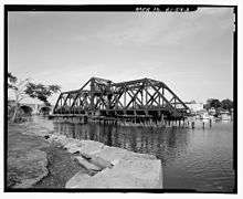 View of swing span from India Point Park looking towards East Providence | |
| Coordinates | 41°49′02″N 71°23′15″W / 41.817098°N 71.387415°WCoordinates: 41°49′02″N 71°23′15″W / 41.817098°N 71.387415°W |
| Carries | Boston and Providence Railroad |
| Crosses | Seekonk River |
| Locale | between Providence and East Providence |
| Characteristics | |
| Design | swing bridge |
| Total length | 403 feet (123 m) |
| Width | 29 feet (8.8 m) |
| Height | 48 feet (15 m) |
| Longest span | 225 feet (69 m) |
| History | |
| Construction begin | 1901 |
| Construction end | 1903 |
| Opened | 1903 |
| Closed | 1974 |
 | |
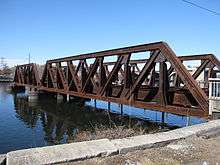
India Point Railroad Bridge was a swing bridge which spanned the Seekonk River, connecting the City of Providence, Rhode Island at India Point to the City of East Providence at Watchemoket. It was last used in 1974, and the swing span was removed in 2001 leaving only two fixed truss spans.
History
The original structure was a covered bridge built in 1835 by Thomas Hassard for the Boston and Providence Railroad. He had been mentored by Colonel Stephen H. Long, inventor of the Long truss. It held the distinction of being the first interstate railroad bridge built in the United States.[1][note 1] The bridge had a manually operated draw consisting of two parts located on the East Providence side of the bridge. In order to let a vessel pass, the eastern part had to be moved northward and the western part was moved into the vacated space. This draw was replaced in 1858 by one resting on a turntable providing a gap of 38 feet (12 m). In 1866, due to the bridge's piers being deemed unreliable, work began on a new bridge adjacent to the existing one that was to have a draw of at least 60 feet (18 m).[3]:10–12 This bridge used a Howe truss and was built by Daniel Harris and Richard Hawkins, who held the patent rights for this design in Southern New England.[1] On 20 February 1868, a successful test run was made, and the main track was connected to the new bridge the following day.[3]:22
In 1882, an iron swing section replaced the manually operated one. This provided a channel of about 38 feet (12 m). However, a curve in the channel made passage through it difficult.[4] The remaining covered part of the bridge was replaced with a steel swing span in 1902 by Boston Bridge Works giving it a channel of approximately 80 feet (24 m) and aligning the draw with that of the 1885 Washington Bridge[note 2] to the north.[5] Finally, the iron swing section was replaced with fixed pony trusses in 1903. Both of these sections were built around the existing spans, so that rail and water traffic would not be interrupted. During peak working hours, trains could cross the bridge at an average rate of one every four minutes.[6]
Removal
The bridge continued to operate until 1974. After its closing, the United States Coast Guard eventually determined the bridge to be a navigational hazard. In May 1990, they threatened to fine the City of Providence US$1000 for each day beyond one year from then that the bridge was neither removed nor illuminated. Though the deadline passed, the Coast Guard delayed imposing any fines until at least 1993, when Federal money was to be made available for the bridge's removal. Under the plan, the Federal government and city were each to pay US$250,000 towards the cost of removing it.[7] However, this plan was not executed. Also, the Water Resources Acts of 1986 and 1996 had each approved plans for removing the bridge, but these plans failed to come to fruition as well.[8]
On 18 December 2000, the Providence City Council approved the transfer of the bridge to the Federal Government. The United States Army Corps of Engineers then advertised to give the bridge to any organization that could demonstrate a suitable disposition for it.[9] No claims were received, so demolition was scheduled to begin in October 2001. By then, the estimated removal cost had increased to US$668,690 which also had been agreed to be split evenly by the Army Corps and the city.[8] At the end of December 2001, the swing span had been dismantled. The final step was to remove the concrete platform measuring 34 feet (10 m) in diameter that supported the swing section.[10] As of May 2014, only the two fixed truss sections on the East Providence side remained.
See also
- Crook Point Bascule Bridge
- List of bridges documented by the Historic American Engineering Record in Rhode Island
- Sakonnet River rail bridge
Notes
- ↑ The area which was ceded to Rhode Island to become East Providence in 1862 was previously part of Seekonk, Massachusetts.[2]
- ↑ At the time, the bridge was known as the "Seekonk River Bridge" but was eventually renamed to match its predecessors.
References
- 1 2 Allen, Richard Sanders (2004). Covered bridges of the Northeast (Dover ed.). Mineola, N.Y.: Dover Publications. pp. 78–79. ISBN 0486436624.
- ↑ Conforti, Joseph (1976). Our Heritage: A History of East Providence. White Plains, New York: Monarch Publishing, Inc. p. 2.
- 1 2 J. Albert Monroe (1868). Description of the Piers of the new Railroad Bridge of the Boston and Providence Railroad over the Seekonk River, etc.
- ↑ Ozog, Edward J. "Rhode Island Railroads". Retrieved 24 February 2014.
- ↑ Rhode Island Historical Resources Archive: Washington Bridge (RIHRA No. EAPR-0001 ed.). Rhode Island Historical Preservation and Heritage Commission. p. 4.
- ↑ Rhode Island Railroad Commissioner (1903). Report. E.L. Freeman Company, state printers.
- ↑ Mingis, Ken (26 December 1991). "No money, so eyesore bridge remains Coast Guard holding off on fining city for violation". Providence Journal. Retrieved 16 March 2014.
- 1 2 "Railroad bridge's days numbered". Providence Journal. 14 September 2001. Retrieved 16 March 2014.
- ↑ "India Point Railroad Bridge Awaiting Qualified Suitor". Providence Business News. Retrieved 22 February 2014.
- ↑ "Demolition continues on India Point Bridge". Providence Journal. 28 December 2001. Retrieved 31 Mar 2014.
External links
| Wikimedia Commons has media related to India Point Railroad Bridge. |
Information
- India Point Railroad Bridge at Structurae
- Article about the Providence, Warren and Bristol Railroad
- Another article about the bridge
- Solicitation for bridge demolition
Images
- Historic American Engineering Record (HAER) No. RI-54, "India Point Railroad Bridge, Spanning Seekonk River between Providence & East Providence, Providence, Providence County, RI", 23 photos, 11 data pages, 5 photo caption pages
- Flooding from the 1938 New England hurricane
- Panoramic view of the bridge
| Common carriers |  | |
|---|---|---|
| Passenger carriers | ||
| Former carriers | ||
See also: List of United States railroads by political division | ||