Interstate 20 in Georgia
| |||||||
|---|---|---|---|---|---|---|---|
_map.svg.png) | |||||||
| Route information | |||||||
| Maintained by Georgia DOT | |||||||
| Length: | 202.61 mi[1][2] (326.07 km) | ||||||
| Existed: | 1963[3] – present | ||||||
| Major junctions | |||||||
| West end: |
 I‑20 at Alabama state line I‑20 at Alabama state line | ||||||
  US 27 / SR 1 near Bremen US 27 / SR 1 near Bremen I‑285 in Atlanta I‑285 in Atlanta  I‑75 / I‑85 in Atlanta I‑75 / I‑85 in Atlanta  US 23 / SR 42 in Atlanta I‑285 near Panthersville US 23 / SR 42 in Atlanta I‑285 near Panthersville  US 278 / SR 12 from Lithonia to Covington US 278 / SR 12 from Lithonia to Covington   US 129 / US 441 / SR 24 south of Madison US 129 / US 441 / SR 24 south of Madison  US 221 / SR 47 north of Harlem US 221 / SR 47 north of Harlem  I‑520 / SR 232 in Augusta I‑520 / SR 232 in Augusta | |||||||
| East end: |
I-20 at South Carolina state line in Augusta | ||||||
| Location | |||||||
| Counties: | Haralson, Carroll, Douglas, Cobb, Fulton, DeKalb, Rockdale, Newton, Walton, Morgan, Greene, Taliaferro, Warren, McDuffie, Columbia, Richmond | ||||||
| Highway system | |||||||
| |||||||


In the U.S. state of Georgia, Interstate 20 (I-20) travels from the Alabama state line to the Savannah River, which the Georgia–South Carolina state line straddles. The highway enters the state near Tallapoosa. It travels through the Atlanta metropolitan area and exits the state in Augusta. The highway also travels through the cities of Douglasville, Covington, and Thomson. I-20 has the unsigned state highway designation of State Route 402 (SR 402).
Route description
I-20 is four lanes wide in much of the state. In the Atlanta metropolitan area, the highway ranges from six lanes wide in the most outlying counties to 10 lanes wide in downtown Atlanta.
I-20 enters the Peach State near Tallapoosa and after traveling through Western Georgia, it enters the Atlanta metropolitan area. On clear days, eastbound motorists get their first view of downtown Atlanta as they crest the top of Six Flags Hill. The Six Flags Over Georgia amusement park is easily visible off exit 46 eastbound. In Atlanta, the highway travels through the heart of the city, crossing I-75/I-85, which share a common expressway (the "Downtown Connector"). It continues though Metropolitan Atlanta eastward and through the eastern half of Georgia until it exits the state, crossing the Savannah River at Augusta.
Several stretches of I-20 are named for various people and reasons:
- From the Alabama state line to I-285 on the west side of Atlanta, I-20 is named the Tom Murphy Freeway, after the former speaker of the Georgia House of Representatives.[4][5]
- Between both the west and east sides of I-285, I-20 was named the Ralph David Abernathy Freeway in 1991 after the late civil rights activist.[6]
- From I-285 in Dekalb County to US 129/US 441/SR 24 south of Madison, I-20 is named the Purple Heart Highway for military veterans who either died or were injured in combat while in service on or after April 15, 1917.[7]
- Between US 129/US 441/SR 24 and the South Carolina state line, I-20 is named the Carl Sanders Highway after the former Georgia governor who was born in Augusta.[8]
History
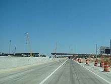
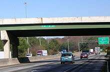
Within Georgia, the first segment of I-20 opened between Downtown Atlanta to Conyers, Georgia. The last part of the highway opened in 1977 or 1978 between Alabama state line to Villa Rica, Georgia[9][10]
Until 2000, the state of Georgia used the sequential interchange numbering system on all of its Interstate Highways. The first exit on each highway would begin with the number "1" and increase numerically with each exit. In 2000, the Georgia Department of Transportation switched to a mileage-based exit system, in which the exit number corresponded to the nearest milepost.[11][12][13]
From the Alabama state line to Villa Rica, I-20 is currently being widened from four to six lanes in ultimate plans to widen to at least six lanes from Birmingham, Alabama to Atlanta. Some sections are currently under construction.
Exit list
| County | Location | mi | km | Old exit | New exit | Destinations | Notes | |
|---|---|---|---|---|---|---|---|---|
| Haralson | | I‑20 west – Birmingham | Continuation into Alabama | |||||
| | 1 | 5 |  SR 100 – Tallapoosa, Bowdon SR 100 – Tallapoosa, Bowdon | |||||
| | 2 | 9 | Waco Road | |||||
| Carroll | | 3 | 11 | US 27 – Bremen, Carrollton | ||||
| | 4 | 19 |  SR 113 – Carrollton, Temple SR 113 – Carrollton, Temple | |||||
| Villa Rica | 5 | 24 |   SR 61 / SR 101 – Carrollton, Villa Rica SR 61 / SR 101 – Carrollton, Villa Rica | |||||
| Douglas | | 6 | 26 | Liberty Road – Villa Rica | Signed as (GA Conn 8), but not from I-20 itself. | |||
| | 7 | 30 | Post Road | |||||
| Douglasville | 8 | 34 |  SR 5 – Douglasville SR 5 – Douglasville | |||||
| 9 | 36 | Chapel Hill Road | ||||||
| 10 | 37 |  SR 92 (Fairburn Road) – Douglasville SR 92 (Fairburn Road) – Douglasville | ||||||
| | 11 | 41 | Lee Road – Lithia Springs | |||||
| | 12 | 44 |  SR 6 (Thornton Road) – Austell SR 6 (Thornton Road) – Austell | |||||
| Cobb | | 13 | 46 | Six Flags Drive, Riverside Parkway | Signed as exits 46A (Riverside Parkway) and 46B (Six Flags Drive) westbound | |||
| | 13C | 47 | Six Flags Parkway | Westbound exit and eastbound entrance | ||||
| Fulton | | 14 | 49 |  SR 70 (Fulton Industrial Boulevard) SR 70 (Fulton Industrial Boulevard) | ||||
| Atlanta | 15 | 51 | I‑285 – Macon, Montgomery, Chattanooga, Greenville | I-285 exits 10A-B; signed as exits 51A (south) and 51B (north). | ||||
| 16 | 52 |  SR 280 (Hamilton E. Holmes Drive) SR 280 (Hamilton E. Holmes Drive) | Signed as exits 52A (south) and 52B (north) westbound | |||||
| 17 | 53 |  SR 139 (Martin Luther King Jr. Drive) SR 139 (Martin Luther King Jr. Drive) | ||||||
| 18 | 54 | Langhorn Street to Cascade Road | Westbound exit and eastbound entrance | |||||
| 19 | 55A | Lowery Boulevard – West End | ||||||
| 20 | 55B | Lee Street – Atlanta University Center, Fort McPherson | Westbound exit and eastbound entrance | |||||
| 21 | 56A |   US 19 / US 29 (McDaniel Street) US 19 / US 29 (McDaniel Street) | Eastbound exit and westbound entrance | |||||
| 22 | 56B | Windsor Street, Spring Street – Turner Field | ||||||
| 23 | 57 | I‑75 / I‑85 – Macon, Montgomery, Chattanooga, Greenville, Charlotte | I-75 / I-85 Exit 247 | |||||
| 24 | 58A | Capitol Avenue – Downtown Atlanta | Westbound exit and eastbound entrance | |||||
| 25 | 58B | Hill Street – Turner Field | Westbound exit and eastbound entrance | |||||
| 26 | 59A | Boulevard – Zoo Atlanta, Cyclorama | ||||||
| 27 | 59B | Memorial Drive, Glenwood Avenue | Eastbound exit and westbound entrance | |||||
| Fulton–DeKalb county line | 28 | 60 | US 23 (Moreland Avenue) | Signed as exits 60A (south) and 60B (north) eastbound | ||||
| DeKalb | 29 | 61A | Maynard Terrace | Eastbound exit and westbound entrance | ||||
| 30 | 61B |  SR 260 (Glenwood Avenue) SR 260 (Glenwood Avenue) | ||||||
| 31 | 62 | Flat Shoals Road | Eastbound exit and westbound entrance | |||||
| | 32 | 63 | Gresham Road, Flat Shoals Road | |||||
| | 33 | 65 |  SR 155 (Candler Road) – Decatur SR 155 (Candler Road) – Decatur | |||||
| | 34 | 66 | Columbia Drive | Eastbound exit and westbound entrance | ||||
| | 35 | 67 | I‑285 – Macon, Chattanooga, Greenville | I-285 south exit 46, north exits 46A-B; signed as exits 67A (south) and 67B (north) westbound. | ||||
| | 36 | 68 | Wesley Chapel Road, Snapfinger Road | |||||
| | 37 | 71 | Panola Road | |||||
| | 38 | 74 | Evans Mill Road, Lithonia Industrial Boulevard – Lithonia | |||||
| | 39 | 75 |  US 278 west / SR 124 (Turner Hill Road) US 278 west / SR 124 (Turner Hill Road) | West end of US 278 overlap | ||||
| Rockdale | | 40 | 78 | Sigman Road | ||||
| Conyers | 41 | 80 | West Avenue – Conyers | |||||
| 42 | 82 |   SR 20 / SR 138 – Conyers, Monroe SR 20 / SR 138 – Conyers, Monroe | ||||||
| | 43 | 84 |  SR 162 (Salem Road) SR 162 (Salem Road) | |||||
| Newton | | 44 | 88 | Almon Road – Porterdale | ||||
| Covington | 45 | 90 | US 278 east – Covington, Oxford | East end of US 278 overlap | ||||
| 45A | 92 | Alcovy Road | ||||||
| | 46 | 93 |  SR 142 – Hazelbrand, Oxford, Covington SR 142 – Hazelbrand, Oxford, Covington | |||||
| | 47 | 98 |  SR 11 – Monroe, Monticello, Social Circle SR 11 – Monroe, Monticello, Social Circle | |||||
| | 48 | 101 | US 278 | |||||
| Walton |
No major junctions | |||||||
| Morgan | | 49 | 105 | Newborn Road – Newborn, Rutledge | ||||
| | 50 | 113 |  SR 83 – Madison, Monticello SR 83 – Madison, Monticello | |||||
| | 51 | 114 | US 129 / US 441 – Madison, Eatonton | |||||
| | 52 | 121 | Seven Islands Road – Buckhead | |||||
| Greene | | 53 | 130 |  SR 44 (Lake Oconee Parkway) – Eatonton SR 44 (Lake Oconee Parkway) – Eatonton | ||||
| Siloam | 54 | 138 |   SR 15 / SR 77 – Siloam, Union Point, Sparta, Greensboro SR 15 / SR 77 – Siloam, Union Point, Sparta, Greensboro | |||||
| Taliaferro | | 55 | 148 |  SR 22 – Crawfordville, Sparta, Mayfield SR 22 – Crawfordville, Sparta, Mayfield | ||||
| Warren | | 56 | 154 | US 278 – Warrenton, Washington | ||||
| | 57 | 160 | Cadley Norwood Road – Norwood | |||||
| | 58 | 165 |  SR 80 – Camak SR 80 – Camak | |||||
| McDuffie | | — | 169 | Thomson | ||||
| | 59 | 172 |  SR 17 – Thomson, Washington SR 17 – Thomson, Washington | |||||
| | 60 | 175 |  SR 150 SR 150 | |||||
| Columbia | | 61 | 183 | US 221 / SR 47 | Only signed as US 221 | |||
| | 62 | 190 |  SR 388 – Grovetown SR 388 – Grovetown | |||||
| Evans | 63 | 194 |  SR 383 (Belair Road/Jimmie Dyess Parkway) – Evans SR 383 (Belair Road/Jimmie Dyess Parkway) – Evans | |||||
| Richmond | Augusta | 63A | 195 | Wheeler Road | ||||
| 64 | 196 | I‑520 east / SR 232 west (Bobby Jones Expressway) | I-520 north exit 1, south exits 1A-B; signed as exits 196A (east) and 196B (west) eastbound | |||||
| — | 197 | Walton Way Extension | Westbound exit and eastbound entrance | |||||
| 65 | 199 |  SR 28 (Washington Road) – Augusta SR 28 (Washington Road) – Augusta | ||||||
| 66 | 200 |  SR 104 (River Watch Parkway) – Augusta SR 104 (River Watch Parkway) – Augusta | ||||||
| I-20 east – Columbia | Continuation into South Carolina | |||||||
1.000 mi = 1.609 km; 1.000 km = 0.621 mi
| ||||||||
See also
-
.svg.png) Georgia (U.S. state) portal
Georgia (U.S. state) portal -
 Atlanta portal
 -
 U.S. Roads portal
 - Transportation in Atlanta
- Central Savannah River Area
References
- ↑ Adderly, Kevin (January 27, 2016). "Table 1: Main Routes of the Dwight D. Eisenhower National System of Interstate and Defense Highways as of December 31, 2015". Route Log and Finder List. Federal Highway Administration. Retrieved July 17, 2016.
- ↑ "Interstate 20". Interstate-Guide.com. Interstate Guide. Retrieved February 15, 2008.
- ↑ State Highway Department of Georgia (1963). State Highway System and Other Principal Connection Roads (PDF) (Map). Scale not given. Atlanta: State Highway Department of Georgia. OCLC 5673161. Retrieved July 10, 2016. (Corrected to June 1, 1963.)
- ↑ "Tom Murphy (1924–2007)". New Georgia Encyclopedia. Retrieved October 19, 2014.
- ↑ "Tom Murphy Freeway: Designated" (PDF). Georgia Department of Transportation. July 18, 1991. Retrieved October 18, 2014.
- ↑ "Ralph David Abernathy Freeway: Designated" (PDF). Georgia Department of Transportation. April 18, 1991. Retrieved October 19, 2014.
- ↑ "Purple Heart Highway: Designated" (PDF). Georgia Department of Transportation. April 8, 1996. Retrieved October 18, 2014.
- ↑ "Carl Sanders Highway: Designated" (PDF). Georgia Department of Transportation. February 15, 1996. Retrieved October 18, 2014.
- ↑ Georgia Department of Transportation (January 1977). Official Highway Map (PDF) (Map) (1977–78 ed.). Scale not given. Atlanta: Georgia Department of Transportation. Retrieved July 17, 2011.
- ↑ Georgia Department of Transportation (January 1979). Official Highway Map (PDF) (Map). Scale not given. Atlanta: Georgia Department of Transportation. Retrieved July 17, 2016.
- ↑ Phillips, Noelle (November 29, 1999). "State Will Change Interstate Exit Numbers in January". SavannahNOW. Retrieved October 18, 2014.
- ↑ Noelle Phillips (December 1, 1999). "Interstate Exit Signs to Get New Numbers in Georgia". The Florida Times-Union. Retrieved October 18, 2014.
- ↑ Ben Deck (January 16, 2000). "DOT to Change Interstate Exit Numbers". Athens Banner-Herald. Retrieved October 18, 2014.
External links
 Media related to Interstate 20 in Georgia at Wikimedia Commons
- Georgia @ SouthEastRoads.com - Interstate 20
- Georgia Navigator — Georgia DOT site with real-time traffic information; includes traffic cameras within metro Atlanta area
- I-20 Augusta Real-Time Traffic Information — Georgia DOT site with real-time traffic information for I-20/I-520 Augusta construction area
- Georgia DOT news and information about I-20/I-520 upgrades in Richmond and Columbia counties
| Interstate 20 | ||
|---|---|---|
| Previous state: Alabama |
Georgia | Next state: South Carolina |
| ||
1Cancelled | ||