Interstate 485 (Georgia)
| |||||||
|---|---|---|---|---|---|---|---|
|
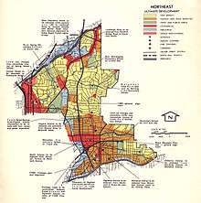
1970 map of proposed route of I-485 through northeast Atlanta | |||||||
| Route information | |||||||
| Length: | 5.9 mi[1] (9.5 km) | ||||||
| Existed: | 1964 – 1975[2] | ||||||
| Location | |||||||
| Counties: | Fulton | ||||||
| Highway system | |||||||
| |||||||



Interstate 485 (I-485) was a proposed Auxiliary Interstate Highway, that would have traveled eastward and then northward from downtown Atlanta, in the U.S. state of Georgia.
Route description

The 5.9-mile-long (9.5 km)[1] route would have begun at the Downtown Connector (I-75/I-85) and used the proposed State Route 410 (SR 410) east to the interchange with the also-proposed SR 400. There, it would have turned north to end at I-85 near Lindbergh Drive (SR 236). Each of those freeways would have continued beyond the termini of I-485. SR 410, the Stone Mountain Freeway, would continue east beyond the I-285 perimeter highway, and SR 400 would extend both south and north outside the perimeter. A short piece of I-485/SR 410 was constructed from I-75/I-85 east to Boulevard NE.[3]
History
Activists in the neighborhood of Morningside, along the SR 400 portion of I-485, were the first to fight the road, although opposition surfaced in a number of nearby surrounding neighborhoods.[4] After I-485, and parts of SR 400 and SR 410, was canceled, a portion of the right-of-way was used to build Freedom Parkway, now part of SR 10. SR 400 north of I-85 was constructed in the early 1990s as a toll road,[5] and the section south of I-285 was constructed in the mid-1980s and designated Interstate 675.[6][7]
See also
-
.svg.png) Georgia (U.S. state) portal
Georgia (U.S. state) portal -
 Atlanta portal
 -
 U.S. Roads portal
 - Transportation in Atlanta
- Interstate 420
References
- 1 2 "Part V - Interstate Withdrawal-Substitution Program - Engineering Data - Interstate System - Highway History". Federal Highway Administration. Retrieved July 15, 2016.
- ↑ Georgia Department of Transportation (January 1975). Official Highway Map (PDF) (Map) (1975–76 ed.). Scale not given. Atlanta: Georgia Department of Transportation. Retrieved July 30, 2016.
- ↑ Georgia State Highway System (PDF) (Map). Cartography by GSHD. Georgia State Highway Department. January 1, 1973. Retrieved October 20, 2013.
- ↑ Wheeler, James O. (1976). "Locational Dimensions of Urban Highway Impact: An Empirical Analysis". Geografiska Annaler. Series B, Human Geography. Blackwell Publishing on behalf of the Swedish Society for Anthropology and Geography. 58 (2): 67–78. JSTOR 490613.
- ↑ Georgia Department of Transportation (1990). Official Highway and Transportation Map (PDF) (Map) (1994–95 ed.). Scale not given. Atlanta: Georgia Department of Transportation. Retrieved July 12, 2016.
- ↑ Georgia Department of Transportation (1986). Official Highway and Transportation Map (PDF) (Map) (1986–87 ed.). Scale not given. Atlanta: Georgia Department of Transportation. Retrieved July 15, 2016.
- ↑ Georgia Department of Transportation (1987). Official Highway and Transportation Map (PDF) (Map) (1987–88 ed.). Scale not given. Atlanta: Georgia Department of Transportation. Retrieved July 15, 2016.
External links
-
 Media related to Interstate 485 (Georgia) at Wikimedia Commons
 - Interstate 485 Georgia on Interstate-guide.com
- The canceled I-485 route (superimposed on Google Maps)
 | ||
| ||