Interstate 5 in Oregon
| ||||
|---|---|---|---|---|
 | ||||
| Route information | ||||
| Maintained by ODOT | ||||
| Length: | 308.14 mi[1] (495.90 km) | |||
| Existed: | August 14, 1957[2][3] – present | |||
| History: | Completed in 1967[4] | |||
| Major junctions | ||||
| South end: |
.svg.png) I-5 at California state line I-5 at California state line | |||
 US 199 in Grants Pass US 199 in Grants Pass  I-105 / OR 126 in Eugene I-105 / OR 126 in Eugene OR 569 in Springfield OR 569 in Springfield US 20 in Albany US 20 in Albany OR 22 in Salem OR 22 in Salem I-205 in Tualatin I-205 in Tualatin I-405 in Portland I-405 in Portland  I-84 / US 30 in Portland I-405 in Portland I-84 / US 30 in Portland I-405 in Portland | ||||
| North end: |
 I‑5 at Washington state line I‑5 at Washington state line | |||
| Highway system | ||||
| ||||


In the U.S. state of Oregon, Interstate 5 traverses the state from north to south, passing through the major cities of Portland, Salem, Eugene, and Medford.
Route description
Beginning with the section about 3 miles (4.8 km) north of the California border, the highway runs from 4,310 feet (1,310 m) Siskiyou Summit, the highest point on I-5,[5] through Oregon's southern mountains and towns such as Ashland, Medford, and Grants Pass. Past Roseburg, the mountains turn into hills, and as it reaches Eugene, the road enters the Willamette River Valley. At Eugene the highway intersects with the short Interstate 105. The interstate then heads almost due north, skirting near Albany and Corvallis, and passes through Salem. There were plans[6] to build a spur into Salem, called Interstate 305.
In Salem, placed in the median near mile marker 260, are signs noting where I-5 crosses the 45th parallel.[7] It bears the words "45th Parallel - Half Way Between the Equator and North Pole".[8]
The highway then tracks a little to the northeast, crossing the Willamette River on the Boone Bridge and passing through the city of Wilsonville before splitting off Interstate 205 south of the Portland metro area. From here it passes up through Tualatin and Tigard along former U.S. Route 99W and through the so-called Terwilliger curves before hitting the southern terminus of I-405 and the Marquam Bridge. Also planned was a spur in Portland off I-405, called Interstate 505, which would have connected to U.S. Highway 30, but that plan was canceled.[9] A stub of what would have been I-505 exists as a long exit ramp to Highway 30.
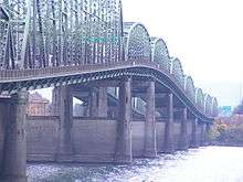
After crossing the Willamette River on the Marquam Bridge, I-5 has junctions at the western terminus of Interstate 84 and the northern terminus of I-405. It then continues through the northern parts of the city of Portland, and crosses into Washington via the Interstate Bridge.
Notably, bicycles are not prohibited from most of I-5 in Oregon,[10] perhaps because in rural and mountain areas, few or no alternate routes exist (having been largely built over the alignment of U.S. 99, which in many places was laid over historic trails). In the early 1970s, restrictions against non-motorized vehicles began appearing in denser urban areas where such use would be unsafe, but, as of April 2007, the rest remains accessible.[11]
State law
Legally, I-5 in Oregon is designated the Pacific Highway No. 1 (see Oregon highways and routes).
Robert Hugh Baldock Freeway
Although not generally referred as such, the portion of I-5 south of Portland near Tigard to Salem was designated the Robert Hugh Baldock Freeway after a former Oregon highway engineer.[12][13]
Gallery
-

In downtown Portland, I-5 runs adjacent to the Willamette River and passes by the Moda Center (center), and Oregon Convention Center (right).
-
_RUNS_DIRECTLY_THROUGH_THIS_ESTABLISHED_RESIDENTIAL_AREA_OF_NORTHEAST_PORTLAND_-_NARA_-_548092.jpg)
Aerial view of the I-5 interchange with Lombard street in a Northeast Portland neighborhood (June 1973).
-
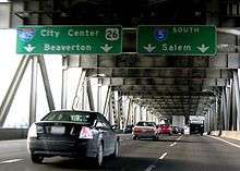
Approaching the southern terminus of I-405 on the Marquam Bridge.
Exit list
| County | Location[14] | mi[14] | km | Exit | Destinations | Notes | ||
|---|---|---|---|---|---|---|---|---|
| Jackson | | 0.00 | 0.00 | — | I-5 south – Yreka | Continuation from California | ||
| | 0.74 | 1.19 | 1 | OR 273 – Siskiyou Summit | Northbound exit and southbound entrance | |||
| | 4.30 | 6.92 | Siskiyou Summit, elevation 4,310 feet (1,310 m) | |||||
| | 5.36 | 8.63 | 6 | OR 273 – Mount Ashland | ||||
| | 11.62 | 18.70 | 11 |  OR 99 north (Siskiyou Boulevard) – Ashland OR 99 north (Siskiyou Boulevard) – Ashland | Northbound exit and southbound entrance | |||
| Ashland | 14.20 | 22.85 | 14 |  OR 66 – Ashland, Klamath Falls OR 66 – Ashland, Klamath Falls | ||||
| | 19.14 | 30.80 | 19 | Valley View Road – Ashland | Valley View Road only appears on northbound signage | |||
| | 21.22 | 34.15 | 21 | Talent | ||||
| Phoenix city line | 24.42 | 39.30 | 24 | Phoenix | ||||
| Medford | 27.24 | 43.84 | 27 | To OR 99 – South Medford | ||||
| 30.32 | 48.80 | 30 |   OR 62 east (Crater Lake Highway) to OR 238 – North Medford, Crater Lake, Medford, Klamath Falls OR 62 east (Crater Lake Highway) to OR 238 – North Medford, Crater Lake, Medford, Klamath Falls | OR 238, North Medford, and Crater Lake only appear on northbound signage; Medford and Klamath Falls only appear on southbound signage | ||||
| Central Point | 32.78 | 52.75 | 33 | Central Point | ||||
| | 35.51 | 57.15 | 35 | OR 99 south / Blackwell Road – Central Point | Southern end of concurrency with OR 99 | |||
| | 40.86 | 65.76 | 40 |  OR 99 north (Rogue-Umpqua Scenic Byway) to OR 234 OR 99 north (Rogue-Umpqua Scenic Byway) to OR 234 | Northbound signage; northern end of concurrency with OR 99 | |||
| Gold Hill | Southbound signage | |||||||
| | 43.80 | 70.49 | 43 | To OR 99 (Rogue River Route) / OR 234 – Gold Hill, Crater Lake | OR 234, Gold Hill, and Crater Lake only appear on southbound signage | |||
| | 45.48 | 73.19 | 45A | OR 99 (Rogue River Route) | ||||
| | 45.75– 46.08 | 73.63– 74.16 | 45B | Valley of the Rogue State Park | ||||
| Rogue River | 48.85 | 78.62 | 48 | City of Rogue River | ||||
| Josephine | | 55.81 | 89.82 | 55 | US 199 south (Redwood Highway) – Ocean Beaches, Crescent City | |||
| Grants Pass | 57.96– 58.34 | 93.28– 93.89 | 58 | OR 99 south to US 199 (Redwood Highway) – Grants Pass City Center | Southern end of OR 99 overlap | |||
| | 61.47 | 98.93 | 61 | Merlin | ||||
| | 66.31 | 106.72 | 66 | Hugo | ||||
| | 69.11 | 111.22 | Sexton Mountain Pass summit, elevation 1,956 feet (596 m) | |||||
| | 71.42 | 114.94 | 71 | Sunny Valley | ||||
| | 73.84 | 118.83 | Smith Hill summit, elevation 1,730 feet (530 m) | |||||
| Wolf Creek | 75.82– 76.78 | 122.02– 123.57 | 76 | Wolf Creek | ||||
| | 78.46 | 126.27 | 78 | Speaker Road | Southbound exit and northbound entrance | |||
| Douglas |
No major junctions | |||||||
| Josephine | | 79.81 | 128.44 | Stage Road Pass summit, elevation 1,830 feet (560 m) | ||||
| Douglas | | 80.79 | 130.02 | 80 | Glendale | |||
| | 83.28 | 134.03 | 83 | Barton Road | Northbound exit and southbound entrance | |||
| Quines Creek | 86.13 | 138.61 | 86 | Quines Creek Road / Barton Road | Barton Road only appears on southbound signage | |||
| | 88.12 | 141.82 | 88 | Azalea, Galesville Reservoir | ||||
| | 90.19 | 145.15 | Stage Road Pass summit, elevation 1,830 feet (560 m) | |||||
| | 95.81 | 154.19 | 95 | Canyon Creek | ||||
| Canyonville | 98.27 | 158.15 | 98 | Canyonville, Days Creek | ||||
| | 99.51 | 160.15 | 99 | North Canyonville, Stanton Park, Crater Lake | Stanton Park only appears on northbound signage; Crater Lake only appears on southbound signage | |||
| | 101.05– 101.39 | 162.62– 163.17 | 101 | Riddle, Stanton Park | Stanton Park only appears on southbound signage | |||
| | 101.89 | 163.98 | 102 | Gazley Road | ||||
| | 103.94 | 167.28 | 103 | Tri-City, Riddle | ||||
| | 106.70 | 171.72 | 106 | Tri-City, Myrtle Creek | Northbound signage | |||
| Weaver Road | Southbound signage | |||||||
| | 107.98– 108.47 | 173.78– 174.57 | 108 | Myrtle Creek | ||||
| | 110.35 | 177.59 | 110 | Boomer Hill Road | ||||
| | 112.12– 112.48 | 180.44– 181.02 | 112 |  OR 99 north to OR 42 west – Dillard, Coos Bay, Winston OR 99 north to OR 42 west – Dillard, Coos Bay, Winston | OR 99 and OR 42 only appear on northbound signage; Winston only appears on southbound signage; northern end of concurrency with OR 99 | |||
| | 113.43 | 182.55 | 113 | Clarks Branch Road – Round Prairie | ||||
| | 116.42 | 187.36 | Roberts Mountain summit, elevation 956 feet (291 m) | |||||
| | 119.50 | 192.32 | 119 | OR 42 west to OR 99 – Winston, Coos Bay | ||||
| | 120.48 | 193.89 | 120 | OR 99 north – South Roseburg | Northbound signage; no northbound entrance | |||
| Green District, Roseburg | Southbound signage | |||||||
| | 121.68 | 195.82 | 121 | McLain Avenue | ||||
| | 123.00 | 197.95 | 123 | Douglas County Fairgrounds, Umpqua Park | ||||
| Roseburg | 124.13 | 199.77 | 124 |  OR 138 east – Roseburg City Center, Diamond Lake OR 138 east – Roseburg City Center, Diamond Lake | Southern end of concurrency with OR 138 | |||
| 125.07 | 201.28 | 125 | Garden Valley Boulevard – Roseburg | |||||
| 126.51 | 203.60 | 127 | Edenbower Boulevard – North Roseburg | |||||
| | 129.45 | 208.33 | 129 | Winchester | Northbound signage | |||
| Wilbur | Southbound signage | |||||||
| Sutherlin | 135.13 | 217.47 | 135 | Sutherlin, Wilbur | ||||
| 136.51 | 219.69 | 136 | OR 138 west – Sutherlin, Elkton | Northern end of concurrency with OR 138 | ||||
| | 138.29 | 222.56 | 138 | Oakland | Northbound exit and southbound entrance | |||
| | 140.53 | 226.16 | 140 | OR 99 south – Oakland | Southern end of concurrency with OR 99; southbound exit and northbound entrance | |||
| | 142.17 | 228.80 | 142 | Metz Hill | ||||
| | 146.24 | 235.35 | 146 | Rice Valley | ||||
| | 142.31 | 229.03 | Rice Hill summit, elevation 723 feet (220 m) | |||||
| Rice Hill | 148.40– 149.59 | 238.83– 240.74 | 148 | Rice Hill | ||||
| | 150.32 | 241.92 | 150 |  OR 99 north to OR 38 – Yoncalla, Drain OR 99 north to OR 38 – Yoncalla, Drain | Northern end of concurrenmcy with OR 99 | |||
| | 154.36– 154.95 | 248.42– 249.37 | 154 | Scotts Valley, Elkhead | ||||
| | 159.27 | 256.32 | 159 | Cox Road – Elk Creek | ||||
| | 160.13 | 257.70 | 160 | Salt Springs Road | ||||
| | 161.70 | 260.23 | 161 | Anlauf, Lorane | Northbound exit only | |||
| | 162.35 | 261.28 | 162 | OR 38 south / OR 99 – Drain, Elkton | Southern end of concurrency with OR 99 | |||
| | 163.43 | 263.02 | 163 | Curtin, Lorane | ||||
| Lane | | 168.36 | 270.95 | 170 | OR 99 north – Cottage Grove | Northern end of concurrency with OR 99; northbound exit and southbound entrance | ||
| | 172.23 | 277.18 | 172 | Sixth Street – Cottage Grove Lake | Southbound exit and northbound entrance | |||
| Cottage Grove | 174.73 | 281.20 | 174 | Cottage Grove, Dorena Lake | ||||
| | 176.75 | 284.45 | 176 | Saginaw | ||||
| Creswell city line | 182.82 | 294.22 | 182 | OR 222 – Creswell | ||||
| | 186.42 | 300.01 | 186 | Dillard Road – Goshen | Northbound exit only | |||
| | 188.33 | 303.09 | 188A |  OR 58 east (Willamette Highway) – Oakridge, Klamath Falls OR 58 east (Willamette Highway) – Oakridge, Klamath Falls | Signed as Exit 188 southbound; OR 99 only appears on northbound signage; Klamath Falls only appears on southbound signage; southern end of concurrency with OR 99 | |||
| | 188.65 | 303.60 | 188B | OR 99 south – Goshen | ||||
| | 189.64– 190.73 | 305.20– 306.95 | 189 | OR 225 / 30th Avenue – South Eugene | ||||
| Springfield–Eugene city line | 191.97 | 308.95 | 191 |   Glenwood Boulevard to OR 126 Bus. east – Downtown Springfield Glenwood Boulevard to OR 126 Bus. east – Downtown Springfield | OR 126 Bus. only appears on northbound signage | |||
| 192.26 | 309.41 | 192 |  OR 99 north / OR 126 Bus. west – University of Oregon, Downtown Eugene OR 99 north / OR 126 Bus. west – University of Oregon, Downtown Eugene | Northern end of concurrency with OR 99; northbound exit and southbound entrance | ||||
| 192.74 | 310.18 | Whilamut Passage Bridge over the Willamette River | ||||||
| 193.71– 194.18 | 311.75– 312.50 | 194A | OR 126 east – Springfield | |||||
| 194B | I-105 west / OR 126 west – Eugene | Exit 4 on I-105 | ||||||
| 195.43– 195.70 | 314.51– 314.95 | 195A | Beltline Road east | Signed as Exit 195 southbound; Beltline Road east only appears on northbound signage; Springfield and Eugene only appears on southbound signage | ||||
| 195B |  OR 569 west (Randy Papé Beltline) – Springfield, Eugene OR 569 west (Randy Papé Beltline) – Springfield, Eugene | |||||||
| Coburg city line | 199.14 | 320.48 | 199 | Coburg National Historic District | ||||
| Linn | | 209.05 | 336.43 | 209 | Harrisburg, Junction City | |||
| | 216.56 | 348.52 | 216 |  OR 228 – Halsey, Brownsville OR 228 – Halsey, Brownsville | ||||
| | 228.08 | 367.06 | 228 |  OR 34 – Lebanon, Corvallis OR 34 – Lebanon, Corvallis | ||||
| Albany | 233.21 | 375.32 | 233 | US 20 (Santiam Highway) – Albany, Lebanon, Sweet Home | Albany only appears on northbound signage; Sweet Home only appears on southbound signage | |||
| 233.85– 234.39 | 376.35– 377.21 | 234A | Knox Butte Road – Linn County Fair and Expo Center | Signed as Exit 234 northbound; OR 99E only appears on southbound signage; no southbound entrance; southern end of concurrency with OR 99E | ||||
| 234B |  OR 99E south – Albany OR 99E south – Albany | |||||||
| Millersburg | 235.66 | 379.26 | 235 | Viewcrest | Northbound signage | |||
| Millersburg | Southbound signage | |||||||
| 237.66 | 382.48 | 237 | Viewcrest | No northbound exit | ||||
| | 238.23 | 383.39 | 238 | OR 164 north – South Jefferson, Scio, Millersburg | South Jefferson only appears on northbound signage; Millersburg only appears on southbound signage | |||
| | 239.66 | 385.70 | 239 | Dever–Conner | ||||
| Linn–Marion county line | | 240.65 | 387.29 | Santiam River | ||||
| Marion | | 242.12 | 389.65 | 242 | Talbot Road | |||
| | 243.52 | 391.91 | 243 | Ankeny Hill | ||||
| | 244.67 | 393.76 | 244 | OR 164 south – North Jefferson, Jefferson | North Jefferson only appears on northbound signage; Jefferson only appears on southbound signage | |||
| | 248.40 | 399.76 | 248 | Delaney Road – Sunnyside, Turner | Sunnyside only appears on northbound signage; Delaney Road only appears on southbound signage | |||
| | 248.57 | 400.03 | 249 | Commercial Street | Northbound exit and southbound entrance | |||
| Salem | 251.52 | 404.78 | 252 | Kuebler Boulevard | ||||
| 253.86 | 408.55 | 253 | OR 22 / OR 99E Bus. north – Detroit Lake, Bend | |||||
| 256.27 | 412.43 | 256 |  OR 213 north (Market Street) – Silverton, Lancaster Mall OR 213 north (Market Street) – Silverton, Lancaster Mall | Silverton only appears on northbound signage; Lancaster Mall only appears on southbound signage | ||||
| 258.62 | 416.21 | 258 | OR 99E north (Portland Road) | Northbound signage; northern end of concurrency with OR 99E | ||||
| North Salem, Oregon State Fairgrounds, L. B. Day Comcast Amphitheatre | Southbound signage | |||||||
| 259.96 | 418.37 | 260A | OR 99E Bus. south (Salem Parkway) | Southbound exit and northbound entrance | ||||
| 260.21 | 418.77 | 260B | Chemawa Road – Keizer | Signed as Exit 260 northbound; Chemawa Road only appears on northbound signage | ||||
| | 263.48 | 424.03 | 263 | Brooks, Gervais | ||||
| Woodburn | 271.85 | 437.50 | 271 |   OR 214 south / OR 219 north – Woodburn, Molalla, Silverton OR 214 south / OR 219 north – Woodburn, Molalla, Silverton | Molalla only appears on northbound signage; Silverton only appears on southbound signage | |||
| | 278.66 | 448.46 | 278 | Ehlen Road – Donald, Aurora National Historic District | Donald only appears on northbound signage; Ehlen Road only appears on southbound signage | |||
| Clackamas | | 282.24 | 454.22 | 282A |  OR 551 south – Canby, Hubbard OR 551 south – Canby, Hubbard | Southbound exit and northbound entrance | ||
| | 282.59 | 454.78 | 282 | Canby | Northbound signage | |||
| 282B | Charbonneau District | Southbound signage | ||||||
| Wilsonville city line | 283.10 | 455.61 | Boone Bridge over the Willamette River | |||||
| Wilsonville | 283.87 | 456.84 | 283 | Wilsonville Road | ||||
| Washington | 286.17 | 460.55 | 286 | OR 141 north (Boones Ferry Road) / Elligsen Road | ||||
| Tualatin | 288.20– 288.97 | 463.81– 465.05 | 288 | I-205 north – Oregon City, West Linn | West Linn only appears on southbound signage | |||
| 289.49 | 465.89 | 289 | Nyberg Street / Tualatin-Sherwood Road | |||||
| 290.47 | 467.47 | 290 | Lower Boones Ferry Road | |||||
| Washington–Clackamas county line | Tigard city line | 291.29 | 468.79 | 291 | Carman Drive | |||
| Tigard–Lake Oswego city line | 292.19 | 470.23 | 292 |  OR 217 north – Tigard, Beaverton OR 217 north – Tigard, Beaverton | Signed as Exit 292 southbound; 72nd Avenue, Tigard, and Beaverton only appear on northbound signage; Lake Oswego only appears on southbound signage | |||
| 292 | Kruse Way, 72nd Avenue – Lake Oswego | |||||||
| Washington | Tigard | 292.90– 293.28 | 471.38– 471.99 | 293 | Haines Street | |||
| Multnomah | Portland | 293.79 | 472.81 | 294 | Barbur Boulevard | Northbound signage | ||
 OR 99W – Tigard, Newberg OR 99W – Tigard, Newberg | Southbound signage | |||||||
| 295.03 | 474.80 | 295 | Capitol Highway | No northbound exit | ||||
| 295.52 | 475.59 | 295 | Taylors Ferry Road | Northbound exit only | ||||
| 296.30 | 476.85 | 296A | Barbur Boulevard | Southbound exit and northbound entrance | ||||
| 296.68 | 477.46 | 296B | Multnomah Boulevard | Southbound exit and northbound entrance | ||||
| 297.16 | 478.23 | 297 | Terwilliger Boulevard | No southbound entrance | ||||
| 298.74 | 480.78 | 298 | Corbett Avenue | Northbound exit only | ||||
| 299.16– 299.83 | 481.45– 482.53 | 299A |   OR 43 (Macadam Avenue) to US 26 east / Ross Island Bridge – Lake Oswego OR 43 (Macadam Avenue) to US 26 east / Ross Island Bridge – Lake Oswego | US 26 and Ross Island Bridge only appear on northbound signage; Lake Oswego only appears on southbound signage | ||||
| 299.51– 300.27 | 482.01– 483.24 | 299B | I-405 north to US 26 west – Portland City Center, Beaverton | No exit number southbound; left exit; left entrance southbound; City Center only appears on northbound signage; Beaverton only appears on southbound signage | ||||
| 300.35– 300.45 | 483.37– 483.53 | Marquam Bridge over the Willamette River | ||||||
| 300.65– 301.91 | 483.85– 485.88 | 300 | I-84 / US 30 east – The Dalles, PDX | Northbound signage; access to OMSI and Central Eastside Industrial District | ||||
| 300B | OR 99E to US 26 east – OMSI, Oregon City | Southbound signage; southbound exit and northbound entrance | ||||||
| 301 | I-84 / US 30 east – The Dalles | Southbound signage; southern end of concurrency with US 30 | ||||||
| 302.08– 302.60 | 486.15– 486.99 | 302A | Broadway, Weidler Street – Moda Center | |||||
| 302.73– 303.47 | 487.20– 488.39 | 302B | I-405 south / US 30 west – St. Helens, Beaverton | Beaverton only appears on southbound signage; northern end of concurrency with US 30 | ||||
| 303.15 | 487.87 | 302C | Greeley Avenue – Swan Island | Northbound exit and southbound entrance | ||||
| 303.75– 304.47 | 488.84– 490.00 | 303 | Killingsworth Street – Swan Island | Northbound signage | ||||
| Alberta Street – Swan Island | Southbound signage | |||||||
| 304.92 | 490.72 | 304 | Rosa Parks Way | |||||
| 305.43 | 491.54 | 305 |  US 30 Byp. (Lombard Street) US 30 Byp. (Lombard Street) | Northbound exit and southbound entrance; signed as Exits 305A (east) and 305B (west) | ||||
| 305.91 | 492.31 | 306A | Columbia Boulevard | Northbound exit and southbound entrance | ||||
| 306.44 | 493.17 | 306B | Victory Boulevard – Expo Center | No southbound exit | ||||
| 306.97 | 494.02 | 306 | Interstate Avenue – Portland International Raceway | Southbound exit and northbound entrance; former OR 99W south | ||||
| 307.33 | 494.60 | 307 | OR 99E south (Martin Luther King Jr. Boulevard) / OR 120 west (Marine Drive) – Delta Park | Delta Park only appears on northbound signage | ||||
| 307.77– 307.99 | 495.31– 495.66 | 308 | Hayden Island, ODOT Permits | |||||
| Columbia River | 308.17– 308.37 | 495.95– 496.27 | Interstate Bridge | |||||
| — | I‑5 north – Seattle | Continuation into Washington | ||||||
1.000 mi = 1.609 km; 1.000 km = 0.621 mi
| ||||||||
See also
 Oregon portal
 U.S. Roads portal
References
- ↑ Federal Highway Administration Route Log and Finder List, Main Routes of the Dwight D. Eisenhower National System Of Interstate and Defense Highways as of October 31, 2002
- ↑ Official Route Numbering for the National System of Interstate and Defense Highways (Map). American Association of State Highway Officials, Public Roads Administration. August 14, 1957. Retrieved April 14, 2013.
- ↑ Weingroff, Richard F. (Summer 1996). "Federal-Aid Highway Act of 1956, Creating the Interstate System". Public Roads. Washington, D.C.: Federal Highway Administration. 60 (1). ISSN 0033-3735. Retrieved April 14, 2013.
- ↑ "I-5 now completed throughout Oregon". The Oregon Motorist. Oregon State Motor Association. 46 (2). February 1967. Retrieved April 14, 2013.
- ↑ 42|3|40.47|N,122|36|24.08|W(GoogleEarth)
- ↑ "The Interstate Highway System in Oregon - A Historic Overview", (pdf, page 62) Oregon Department of Transportation
- ↑ https://foursquare.com/v/45th-parallel/4bab6967f964a52056a73ae3
- ↑ http://www.newgeography.com/content/001449-the-forty-fifth-parallel
- ↑ Redden, Jim (September 10, 2009). "After 35 years of waiting, TriMet's Green Line hits all the parties: Thousands ride new I-205 line that was born of a '70s freeway rebellion". Portland Tribune. Retrieved August 14, 2012.
- ↑ "OAR Banning Non-Motorized Travel On Some Interstate Freeways in Oregon" (PDF). Oregon.gov. Oregon.gov. Retrieved 22 August 2014.
- ↑ "OregonLive.com". Archived from the original on September 30, 2007. Retrieved August 6, 2007.
- ↑ Oregon_Interstate_Highway_Overview_2004.pdf
- ↑ RHSamBaldock.pdf
- 1 2 Road Inventory and Classification Services Unit. "Straightline Charts". Transportation Development Division, Oregon Department of Transportation. Retrieved September 24, 2016.
- Pacific Highway No. 1 (October 2013)

External links
 Media related to Interstate 5 in Oregon at Wikimedia Commons
| Interstate 5 | ||
|---|---|---|
| Previous state: California |
Oregon | Next state: Washington |
| ||
| ||