Interstate 70 in Kansas
| ||||
|---|---|---|---|---|
_map.svg.png) | ||||
| Route information | ||||
| Maintained by Kansas DOT | ||||
| Length: | 424.15 mi[1] (682.60 km) | |||
| Existed: | 1956 – present | |||
| Major junctions | ||||
| West end: |
  I-70 / US 24 at Colorado state line I-70 / US 24 at Colorado state line | |||
  I-135 / US-81 in Salina I-135 / US-81 in Salina  I-470 / US-75 near Topeka I-470 / US-75 near Topeka   US-40 / K-4 / Kansas Turnpike / I-470 near Topeka US-40 / K-4 / Kansas Turnpike / I-470 near Topeka I-435 in Kansas City I-435 in Kansas City I-635 in Kansas City I-635 in Kansas City I-670 in Kansas City I-670 in Kansas City | ||||
| East end: |
 I-70 / US 24 / US 40 / US 169 at Missouri state line I-70 / US 24 / US 40 / US 169 at Missouri state line | |||
| Highway system | ||||
| ||||
.svg.png)

In the U.S. state of Kansas, Interstate 70 contains the first segment to start being paved and to be completed in the Interstate Highway System. It extends from the Colorado border near the town of Kanorado to the Missouri border in Kansas City. The route covers 424 miles (682 km) and passes through several of the state's principal cities in the process including Kansas City, Topeka, and Salina. The route also passes through the cities of Lawrence, Junction City, and Abilene.
Route description

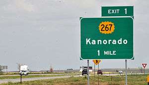
I-70 is concurrent with US-24 from the Colorado state line until US-24 splits at Levant and runs north of I-70. At Colby, I-70 begins to turn southeast until it reaches Oakley, where US-40 joins with I-70 for a concurrent journey through most of the state. The route remains flat until it reaches the county line between Russell and Ellsworth counties, where the road begins to travese rolling hills.
At Salina, Interstate 135 begins its journey southward toward Wichita, and I-70 continues through Abilene and Junction City, where the road begins to run through the Flint Hills.
In Topeka, I-70 intersects a child route, I-470, twice. The second time it is intersected, the Kansas Turnpike merges, making I-70 into a toll road. This is one of only two sections of I-70 that are tolled (the other is along the Pennsylvania Turnpike), with the maximum toll distance costing $17.50 as of 2016.[2] I-70 carries this designation from Topeka to Bonner Springs. It is the eastern terminus of the turnpike, and from there to 18th Street and extending on to the Kansas eastern border, the highway is free.
I-70 enters Missouri via a main northern route on the Lewis and Clark Viaduct above the confluence of the Kansas River and Missouri River and a route designated "Alternate I-70" which has signs for I-70 as well as Interstate 670 just south of Kansas City main downtown area.
From Exit 275 at Abilene to the Missouri state line, the road is named the Dwight D. Eisenhower-Harry S. Truman Presidential Highway. It retains the designation until Exit 16 in Missouri at Independence, the location of Truman's presidential library.
History
The section of I-70 that is now the Kansas Turnpike was finished by 1956 and opened to traffic.[3][4] West of Topeka, the freeway was constructed from Topeka west to Salina at its junction with U.S. Route 81, as well as from Ogallah to Grainfield.[5] From Salina, the freeway was completed through Wilson the next year. A segment of I-70 from Levant through Ogallah was finished by 1965.[6] Another section was built the following year connecting Wilson to Grainfield.[7] The freeway was completed through Kansas with a last section near the Colorado border in 1970.[8]
Exit list
Exit numbers correspond to the mileposts where they're located (numbered east from the Colorado border), except for those at miles 381, 386, 388, 396, and 408, which are part of the Kansas Turnpike and use its mileposts (numbered north from the Oklahoma border) instead.
| County | Location | mi | km | Exit | Destinations | Notes | ||
|---|---|---|---|---|---|---|---|---|
| Colorado–Kansas state line | 0 | 0.0 | I-70 / US 24 continue west into Colorado | |||||
| Sherman | | 1 | 1.6 | 1 |  K-267 – Kanorado K-267 – Kanorado | |||
| | 9 | 14 | 9 | County Road 11 | ||||
| | 12 | 19 | 12 | County Road 14 | ||||
| Goodland | 17 | 27 | 17 |    US-24 Bus. east / K-27 – Sharon Springs, St. Francis US-24 Bus. east / K-27 – Sharon Springs, St. Francis | ||||
| 19 | 31 | 19 | US-24 Bus. west – Goodland | |||||
| | 27 | 43 | 27 |  K-253 – Edson K-253 – Edson | ||||
| Thomas | | 36 | 58 | 36 |  K-184 – Brewster K-184 – Brewster | |||
| | 45 | 72 | 45 | US-24 east – Levant | Eastern terminus of US-24 concurrency | |||
| Colby | 53 | 85 | 53 |  K-25 – Leoti, Atwood K-25 – Leoti, Atwood | ||||
| | 54 | 87 | 54 | Country Club Drive | ||||
| | 62 | 100 | 62 | County Road K | ||||
| | 70 | 110 | 70 |  US-83 – Oakley, Rexford US-83 – Oakley, Rexford | ||||
| Logan |
No major junctions | |||||||
| Gove | | 76 | 122 | 76 | US-40 west – Oakley, Sharon Springs | Western terminus of US-40 concurrency | ||
| | 79 | 127 | 79 | Campus Road | ||||
| | 85 | 137 | 85 |  K-216 – Grinnell K-216 – Grinnell | ||||
| | 93 | 150 | 93 |  K-23 – Grainfield, Gove K-23 – Grainfield, Gove | ||||
| | 95 | 153 | 95 | To K-23 north – Grainfield, Hoxie | ||||
| | 99 | 159 | 99 |  K-211 – Park K-211 – Park | ||||
| Quinter | 107 | 172 | 107 |  K-212 / Castle Rock Road – Quinter K-212 / Castle Rock Road – Quinter | ||||
| Trego | | 115 | 185 | 115 |  K-198 north – Collyer K-198 north – Collyer | |||
| | 120 | 190 | 120 | Voda Road | ||||
| WaKeeney | 127 | 204 | 127 |  US-40 Bus. east / US-283 – WaKeeney, Ness City US-40 Bus. east / US-283 – WaKeeney, Ness City | ||||
| 128 | 206 | 128 | US-40 Bus. west to US-283 north – WaKeeney, Hill City | |||||
| | 135 | 217 | 135 |  K-147 – Ogallah K-147 – Ogallah | ||||
| | 140 | 230 | 140 | Riga Road | ||||
| Ellis | Ellis | 145 | 233 | 145 |  K-247 – Ellis K-247 – Ellis | |||
| | 153 | 246 | 153 | Yocemento Avenue | ||||
| Hays | 157 | 253 | 157 |    US-183 Byp. – Hays, La Crosse US-183 Byp. – Hays, La Crosse | ||||
| 159 | 256 | 159 | US-183 – Hays, Stockton | |||||
| | 161 | 259 | 161 | Commerce Parkway | ||||
| | 163 | 262 | 163 | Toulon Avenue | ||||
| | 168 | 270 | 168 |  K-255 – Victoria K-255 – Victoria | ||||
| | 172 | 277 | 172 | Walker Avenue | ||||
| Russell | | 175 | 282 | 175 | Gorham, 176th Street | Former K-257 | ||
| | 180 | 290 | 180 | Balta Road | ||||
| Russell | 184 | 296 | 184 |  US-40 Bus. east / US-281 – Russell, Hoisington US-40 Bus. east / US-281 – Russell, Hoisington | ||||
| | 189 | 304 | 189 | US-40 Bus. west / Pioneer Road | ||||
| | 193 | 311 | 193 | Bunker Hill Road | ||||
| Dorrance | 199 | 320 | 199 | Dorrance | Former K-231 | |||
| Ellsworth | | 206 | 332 | 206 |  K-232 – Wilson, Lucas K-232 – Wilson, Lucas | |||
| | 209 | 336 | 209 | Sylvan Grove | ||||
| | 216 | 348 | 216 | Vesper | ||||
| | 219 | 352 | 219 |  K-14 south – Ellsworth K-14 south – Ellsworth | West end of K-14 overlap | |||
| | 221 | 356 | 221 | K-14 north – Lincoln | East end of K-14 overlap | |||
| | 225 | 362 | 225 |  K-156 – Ellsworth, Great Bend K-156 – Ellsworth, Great Bend | ||||
| Lincoln | | 233 | 375 | 233 | Beverly, Carneiro | |||
| Saline | | 238 | 383 | 238 | Brookville, Tescott | |||
| | 244 | 393 | 244 | Hedville, Culver | ||||
| | 249 | 401 | 249 | Halstead Road | ||||
| | 250 | 400 | 250A–B | I-135 / US-81 – Wichita, Concordia | Northern terminus of I-135, exits 95A-B. | |||
| Salina | 252 | 406 | 252 |  K-143 (Ninth Street) K-143 (Ninth Street) | ||||
| | 253 | 407 | 253 | Ohio Street | ||||
| | 260 | 420 | 260 | Niles Road | ||||
| Dickinson | Solomon | 266 | 428 | 266 | Solomon Road | former K-221 | ||
| | 272 | 438 | 272 | Fair Road | ||||
| Abilene | 275 | 443 | 275 |  K-15 – Abilene, Clay Center K-15 – Abilene, Clay Center | ||||
| | 277 | 446 | 277 | Jeep Road | ||||
| | 281 | 452 | 281 |  K-43 – Enterprise K-43 – Enterprise | ||||
| | 286 | 460 | 286 |  K-206 – Chapman K-206 – Chapman | ||||
| Geary | | 290 | 470 | 290 | Milford Lake Road | |||
| Junction City | 295 | 475 | 295 |   US-77 / K-18 west – Marysville, Herington US-77 / K-18 west – Marysville, Herington | West end of K-18 overlap | |||
| 296 | 476 | 296 | US-40 Bus. east (Washington Street) | |||||
| 298 | 480 | 298 | East Street, Chestnut Street | |||||
| Grandview Plaza | 299 | 481 | 299 | J Hill Road, Flinthills Boulevard | ||||
| 300 | 480 | 300 |  US-40 Bus. west / K-57 – Council Grove US-40 Bus. west / K-57 – Council Grove | |||||
| | 301 | 484 | 301 | Fort Riley, Marshall Field | ||||
| | 303 | 488 | 303 | K-18 east – Ogden, Manhattan | East end of K-18 overlap | |||
| | 304 | 489 | 304 | Humboldt Creek Road | ||||
| | 307 | 494 | 307 | McDowell Creek Road | ||||
| | 311 | 501 | 311 | Moritz Road | ||||
| | 313 | 504 | 313 |  K-177 – Council Grove, Manhattan K-177 – Council Grove, Manhattan | ||||
| Riley | | 316 | 509 | 316 | Deep Creek Road | |||
| | 318 | 512 | 318 | Frontage Road | ||||
| Wabaunsee | | 322 | 518 | 322 | Tallgrass Road | |||
| | 324 | 521 | 324 | Wabaunsee Road | ||||
| | 328 | 528 | 328 |  K-99 – Wamego, Alma K-99 – Wamego, Alma | ||||
| | 330 | 530 | 330 |  K-185 – McFarland K-185 – McFarland | ||||
| | 332 | 534 | 332 | Spring Creek Road | ||||
| | 333 | 536 | 333 |  K-138 – Paxico K-138 – Paxico | ||||
| | 335 | 539 | 335 | Snokomo Road | ||||
| | 338 | 544 | 338 | Vera Road | ||||
| | 341 | 549 | 341 |  K-30 – Maple Hill K-30 – Maple Hill | ||||
| | 342 | 550 | 342 | Keene-Eskridge Road | ||||
| | 343 | 552 | 343 | Ranch Road | Private interchange for Hudson Ranch | |||
| Shawnee | | 346 | 557 | 346 | Carlson Road | |||
| | 347 | 558 | 347 | West Union Road | ||||
| | 350 | 560 | 350 | Valencia Road | ||||
| | 351 | 565 | 351 | Frontage Road | Eastbound exit and westbound entrance | |||
| | 353 | 568 | 353 | K-4 west (Auburn Road) | West end of K-4 overlap | |||
| Topeka | 355 | 571 | 355 | I-470 east / US-75 south – Topeka | West end of US-75 overlap. Western terminus of I-470, exit 1A to 70 east. | |||
| 356 | 573 | 356 | Wanamaker Road | |||||
| 357 | 575 | 357A | Fairlawn Road | Signed as exit 357 eastbound | ||||
| 357 | 575 | 357B | Danbury Lane | Westbound exit only | ||||
| 358 | 576 | 358A | US-75 north | East end of US-75 overlap; signed as exit 358 eastbound | ||||
| 358 | 576 | 358B | Gage Boulevard | Signed as exit 358 eastbound | ||||
| 359 | 578 | 359 | MacVicar Avenue | |||||
| 361 | 581 | 361A | 1st Avenue | Provides access to Topeka Boulevard. Eastbound exit and westbound entrance. | ||||
| 361 | 581 | 361B | 3rd Street, Monroe Street | Eastbound exit and westbound entrance | ||||
| 362 | 583 | 362A | 4th Street | Westbound exit and eastbound entrance | ||||
| 362 | 583 | 362B | 8th Avenue | Signed as exit 362 eastbound | ||||
| 362 | 583 | 362C | 10th Avenue, Madison Street | Westbound exit and eastbound entrance | ||||
| 363 | 584 | 363 | Adams Street, Branner Trafficway | |||||
| 364 | 586 | 364A | California Avenue | |||||
| 364 | 586 | 364B | Carnahan Avenue, Deer Creek Trafficway | |||||
| 365 | 587 | 365 | Rice Road | |||||
| 366 | 589 | 366 | US-40 east / K-4 east – Valley Falls | Last free exit eastbound, East end of US 40/K-4 overlap | ||||
| 367 | 591 | East Topeka Interchange toll plaza West end of toll road | ||||||
| 367 | 591 | 183 | I-470 west / Kansas Turnpike west | West end of Kansas Turnpike overlap, westbound I-70 exits turnpike on exit 183, eastbound exit and westbound entrance for I-470 are via exit 366 | ||||
| | 372 | 599 | Topeka Service Area | |||||
| Douglas | | 381 | 613 | 197 |  K-10 east – Lecompton, Lawrence K-10 east – Lecompton, Lawrence | Access to Lecompton provided by CR 438. | ||
| Lawrence | 386 | 621 | 202 |  To US-59 south – Lawrence To US-59 south – Lawrence | ||||
| 388 | 624 | 204 | US-40 / US-59 to US-24 – Lawrence | |||||
| | 393 | 632 | Lawrence Service Area | |||||
| Leavenworth | Tonganoxie | 396 | 637 | 212 | Tonganoxie, Eudora | |||
| Wyandotte | Kansas City | 401 | 645 | Eastern Terminal toll plaza East end of toll road | ||||
| 408 | 657 | 224 |   K-7 / US-73 north / US-24 west / US-40 west – Leavenworth, Bonner Springs K-7 / US-73 north / US-24 west / US-40 west – Leavenworth, Bonner Springs | Last free exit westbound, west end of US 24 / US 40 overlap. Westbound exits signed as Exit 224A (south) and Exit 224B (north) | ||||
| 410 | 660 | 410 | 110th Street, Kansas Speedway | |||||
| 411 | 661 | 411A–B | I-435 | I-435 exits 12A-B; signed as exits 411A (south) and 411B (north). | ||||
| 414 | 666 | 414 | 78th Street | |||||
| 415 | 668 | 415 | Turner Diagonal, College Parkway | Signed as exits 415A (Turner Diagonal) and 415B (College Parkway) eastbound | ||||
| 417 | 671 | 417 | 57th Street | |||||
| 418 | 673 | 418A–B | I-635 – St Joseph, Wichita | Signed as exits 418A (north) and 418B (south) eastbound, westbound exit is part of exit 419. I-635 exits 4A-B. | ||||
| 419 | 674 | 419 | Park Drive, 38th Street | |||||
| 420 | 680 | 420A |  US-69 south (18th Street Expressway) US-69 south (18th Street Expressway) | West end of US-69 overlap, east end of Kansas Turnpike | ||||
| 420 | 680 | 420B | 18th Street north | |||||
| 421 | 678 | 421A | Railroad Yard | Westbound exit and eastbound entrance | ||||
| 421 | 678 | 421B |  I-670 east to I-35 south I-670 east to I-35 south | Eastbound exit and westbound entrance, however, westbound traffic can turn around at exit 421A | ||||
| 422 | 679 | 422A | US-69 north (7th Street Trafficway) | East end of US-69 overlap | ||||
| 422 | 679 | 422B | US-169 south (7th Street Trafficway) | West end of US-169 overlap | ||||
| 422 | 679 | 422C | Pacific Avenue | |||||
| 422 | 679 | 422D | Central Avenue | |||||
| 423 | 681 | 423A | 5th Street | Eastbound exit and westbound entrance | ||||
| 423 | 681 | 423B | James Street, 3rd Street | Eastbound exit and westbound entrance | ||||
| 423 | 681 | 423C | Minnesota Avenue, Washington Boulevard | Westbound exit and eastbound entrance | ||||
| 423 | 681 | 423D | Fairfax District | Westbound exit and eastbound entrance | ||||
| Kansas–Missouri state line | 423 | 681 | I-70 / US 24 / US 40 / US 169 continue east into Missouri | |||||
1.000 mi = 1.609 km; 1.000 km = 0.621 mi
| ||||||||
Auxiliary routes
I-70 has two auxiliary routes in Kansas:
- I-470 - a loop around the southern side of Topeka, signed as the Dr. Martin Luther King, Jr. Memorial Highway and overlapping the Kansas Turnpike on the southeast side of town.
- I-670 - an alternate route for I-70 travelers through downtown Kansas City, signed as the Dillingham Freeway and as Alternate I-70.
References
- ↑ "Route Log and Finder List - Interstate System - table 1". Federal Highway Administration. 2002-10-31. Retrieved 2007-07-08.
- ↑ Template:Tolls - Kansas Turnpike Authority
- ↑ "Big Impact Seen For Local Area In Superhighway". Lawrence Daily Journal-World. October 24, 1956. pp. 1–2.
- ↑ "KTA Officials Say Traffic Heavy on Pike This Morning". Lawrence Daily Journal-World. October 20, 1956.
- ↑ 1963-1964 Kansas State Highway Map (Map). Kansas Department of Transportation. Retrieved February 26, 2011.
- ↑ 1965 Kansas State Highway Map (Map). Kansas Department of Transportation. Retrieved February 26, 2011.
- ↑ 1966 Kansas State Highway Map (Map). Kansas Department of Transportation. Retrieved February 26, 2011.
- ↑ 1970 Kansas State Highway Map (Map). Kansas Department of Transportation. Retrieved February 27, 2011.
External links
- Kansas Highway Maps: Current, Historic, KDOT
- Big Ol' Windfarm in Kansas on YouTube - video of the Smoky Hills Wind Farm around mile 230 on Interstate 70, near Ellsworth
| Interstate 70 | ||
|---|---|---|
| Previous state: Colorado |
Kansas | Next state: Missouri |