Isselburg
| Isselburg | |||
|---|---|---|---|
| |||
 Isselburg | |||
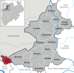
Location of Isselburg within Borken district 
 | |||
| Coordinates: 51°49′59″N 06°28′00″E / 51.83306°N 6.46667°ECoordinates: 51°49′59″N 06°28′00″E / 51.83306°N 6.46667°E | |||
| Country | Germany | ||
| State | North Rhine-Westphalia | ||
| Admin. region | Münster | ||
| District | Borken | ||
| Government | |||
| • Mayor | Rudolf Geukes (SPD) | ||
| Area | |||
| • Total | 42.73 km2 (16.50 sq mi) | ||
| Population (2015-12-31)[1] | |||
| • Total | 10,736 | ||
| • Density | 250/km2 (650/sq mi) | ||
| Time zone | CET/CEST (UTC+1/+2) | ||
| Postal codes | 46419 | ||
| Dialling codes | 0 28 74 | ||
| Vehicle registration | BOR | ||
| Website | www.isselburg.de | ||
Isselburg is a town in the district of Borken, in North Rhine-Westphalia, Germany. It is located on the river Issel, near the border of the Netherlands, and approximately 10 km west of Bocholt.
Division
The largest villages are Anholt, Isselburg, and Werth. Smaller communities include Vehlingen, Herzebocholt and Heelden.
Gallery
- Werth, former town hall
- Anholt, Ratskeller, former town hall
- Anholt, church: Friedenskirche
 Isselburg, Ständebaum decorated as a maypole
Church at Anholt
St. Pankratius at Anholt (built 1851 – 1862)

See also Architecture of cathedrals and great churches, Romanesque revival style (German: Neoromanischer Stil)
| Wikimedia Commons has media related to Isselburg. |
References
- ↑ "Amtliche Bevölkerungszahlen". Landesbetrieb Information und Technik NRW (in German). 18 July 2016.
This article is issued from Wikipedia - version of the 7/25/2016. The text is available under the Creative Commons Attribution/Share Alike but additional terms may apply for the media files.

