Janq'u Jaqhi (Ingavi)
This article is about the mountain in the Ingavi Province, La Paz Department, Bolivia. For other uses, see Janq'u Jaqhi.
| Janq'u Jaqhi | |
|---|---|
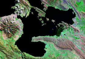 Wiñaymarka as seen from above with Janq'u Jaqhi south of it (bottom, center-left) | |
| Highest point | |
| Elevation | 4,254 m (13,957 ft) [1] |
| Coordinates | 16°35′54″S 68°58′26″W / 16.59833°S 68.97389°WCoordinates: 16°35′54″S 68°58′26″W / 16.59833°S 68.97389°W |
| Geography | |
 Janq'u Jaqhi Location within Bolivia | |
| Location |
Bolivia La Paz Department |
| Parent range | Andes, Chilla-Kimsa Chata |
Janq'u Jaqhi (Aymara janq'u white, jaqhi precipice, cliff,[2][3] "white cliff", also spelled Jankho Jakke) is a 4,254-metre-high (13,957 ft) mountain in the Chilla-Kimsa Chata mountain range in the Andes of Bolivia. It is situated in the La Paz Department, Ingavi Province, Desaguadero Municipality. Janq'u Jaqhi lies south of Wiñaymarka Lake, the southern branch of Lake Titicaca.[1][4]
References
- 1 2 IGM map 1:50,000 5844-III Guaqui
- ↑ Radio San Gabriel, "Instituto Radiofonico de Promoción Aymara" (IRPA) 1993, Republicado por Instituto de las Lenguas y Literaturas Andinas-Amazónicas (ILLLA-A) 2011, Transcripción del Vocabulario de la Lengua Aymara, P. Ludovico Bertonio 1612 (Spanish-Aymara-Aymara-Spanish dictionary)
- ↑ www.ucb.edu.bo Aymara-Spanish dictionary
- ↑ "Desaguadero". INE, Bolivia. Retrieved October 25, 2014.

This article is issued from Wikipedia - version of the 5/5/2016. The text is available under the Creative Commons Attribution/Share Alike but additional terms may apply for the media files.