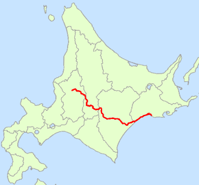
Japan National Route 38
| |
|---|---|
| 国道38号 (Kokudō sanjūhachi-gō) | |
 | |
| Route information | |
| Length: | 298.4 km (185.4 mi) |
| Highway system | |
|
National highways of Japan Expressways of Japan | |
National Route 38 is a national highway connecting Takikawa and Kushiro in Hokkaidō, Japan.
Route Data
- Length: 298.4 km (185.5 mi)
- Origin: Takikawa, Hokkaido (originates at junction with Routes 12 and 451)
- Terminus: Kushiro, Hokkaido (ends at the origin of Route 44)
- Major cities: Ashibetsu, Furano, Obihiro
History
- 1952-12-04 - First Class National Highway 38 (from Takikawa to Kushiro)
- 1965-04-01 - General National Highway 38 (from Takikawa to Kushiro)
Overlapping sections
- In Ashibetsu, from North-2 West-1 South intersection to Ashibetsu-bashi intersection: Route 452
- In Frano, from Wakamatsu-cho 15 intersection to Higashiyama-yanagi intersection: Route 237
- In Shimizu, South-1-11 to South-4-11: Route 274
- From Obihiro (Odori North-1 intersection) to Makubetsu (Akeno intersection): Route 242
- From Urahoro (Yoshino-Kyoei intersection) to the terminus: Route 336
- From Shiranuka (West-1 South-2 intersection) to Kushiro (Otanoshike intersection): Route 392
- From Kushiro (Kitaodori-5 intersection) to the terminus :Routes 44, 272 and 391
Intersects with
| Wikimedia Commons has media related to Route 38 (Japan). |
This article is issued from Wikipedia - version of the 11/5/2016. The text is available under the Creative Commons Attribution/Share Alike but additional terms may apply for the media files.
