John Lawrence Island
| Nickname: Sir John Lawrence Island | |
|---|---|
 John Lawrence Island  John Lawrence Island | |
| Geography | |
| Location | Bay of Bengal |
| Coordinates | 12°06′N 93°01′E / 12.10°N 93.02°ECoordinates: 12°06′N 93°01′E / 12.10°N 93.02°E |
| Archipelago | Andaman Islands |
| Adjacent bodies of water | Indian Ocean |
| Total islands | 1 |
| Major islands |
|
| Area | 34.8 km2 (13.4 sq mi)[1] |
| Length | 13.3 km (8.26 mi) |
| Width | 4.3 km (2.67 mi) |
| Coastline | 34.3 km (21.31 mi) |
| Highest elevation | 0 m (0 ft)[2] |
| Administration | |
| District | South Andaman |
| Island group | Andaman Islands |
| Island sub-group | Ritchie's Archipelago |
| Tehsil | Port Blair Tehsil |
Largest settlement | |
| Demographics | |
| Demonym | Hindi |
| Population | 0 (2011) |
| Pop. density | 0.00 /km2 (0 /sq mi) |
| Ethnic groups | Hindu, Andamanese |
| Additional information | |
| Time zone | |
| PIN | 744202[3] |
| Telephone code | 031927 [4] |
| Official website |
www |
| ISO Code | IN-AN-00[5] |
| Literacy | 84.4% |
| Avg. summer temperature | 30.2 °C (86.4 °F) |
| Avg. winter temperature | 23.0 °C (73.4 °F) |
| Sex ratio | 1.2♂/♀ |
| unit_pref | Metric |
| Census Code | 35.639.0004 |
| Official Languages | Hindi, English |
John Lawrence Island is an island of the Andaman Islands. It belongs to the South Andaman administrative district, part of the Indian union territory of Andaman and Nicobar Islands.[6] the island is lying 54 km (34 mi) northeast from Port Blair.
Etymology
John Lawrence is named after Baronet Sir John Lawrence.
Geography
The island belongs to the Ritchie's Archipelago and is located between Peel Island and Sir John Lawrence's Brother: Henry Lawrence Island. John Lawrence Island is long in shape. It is surrounded by beaches on three sides. Since the island is quite long in shape, the beach stretches to a long distance. [7]
Administration
Politically, John Lawrence Island is part of Port Blair Taluk.[8]
Demographics
The island is uninhabited.
Transportation
The only way to reach John Lawrence Island is by local boat services. There is boat service from Port Blair and Havelock Island through which you can reach this island. However, boat rides are subject to weather and condition of the sea. There is a small channel between John Lawrence Island and Henry Lawrence Island that is lined with thick mangrove forests. Terrestrial moist forests and mangroves form the main vegetation of John Lawrence Island.
Image gallery
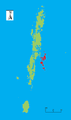 Outline map of the Andaman Islands, with Ritchie's Archipelago highlighted (in red).
References
- ↑ "Islandwise Area and Population - 2011 Census" (PDF). Government of Andaman.
- ↑ "Sailing Directions (enroute) | India and the Bay of Bengal" (PDF) (173). National Geospatial-intelligence Agency, United States Government. 2014. Retrieved 2016-09-23.
- ↑ "A&N Islands - Pincodes". 22 September 2016. Retrieved 22 September 2016.
- ↑ "STD Codes of Andaman and Nicobar". allcodesindia.in. Retrieved 2016-09-23.
- ↑ Registration Plate Numbers added to ISO Code
- ↑ "Village Code Directory: Andaman & Nicobar Islands" (PDF). Census of India. Retrieved 2011-01-16.
- ↑
- ↑ "DEMOGRAPHIC – A&N ISLANDS" (PDF). andssw1.and.nic.in. Retrieved 2016-09-23.
| Wikimedia Commons has media related to Ritchie's Archipelago. |
 Ritchie's Archipelago travel guide from Wikivoyage