John Roy Site
|
John Roy Site | |
|
Fields at the site | |
 | |
| Location | Southwest of the junction of 1700th Ave. and 2950th St. |
|---|---|
| Nearest city | Clayton, Illinois |
| Coordinates | 40°1′45″N 90°57′29″W / 40.02917°N 90.95806°WCoordinates: 40°1′45″N 90°57′29″W / 40.02917°N 90.95806°W |
| Area | 3 acres (1.2 ha) |
| NRHP Reference # | 78001109[1] |
| Added to NRHP | May 22, 1978 |
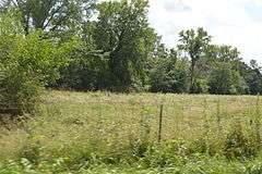
The John Roy Site is a pre-Columbian archaeological site located roughly 2 miles (3.2 km) south of Clayton in Adams County, Illinois. The site consists of a Woodland period village site inhabited from roughly 450 to 650 A.D.; five burial mounds are also associated with the site. The site's upland location is uncommon for village sites from the period, which have mostly been located in river valleys. The location may have been affected by the development of plant cultivation at the time, and extensive seed deposits at the site provide insight into developing agricultural practices. In addition, preserved remnants of woven artifacts have been found at the site; such items are rare and may help explain how weaving developed during the period.[2]
The site was added to the National Register of Historic Places on May 22, 1978.[1]
See also
Notes
- 1 2 National Park Service (2010-07-09). "National Register Information System". National Register of Historic Places. National Park Service.
- ↑ Maruszak, Kathleen. National Register of Historic Places Inventory/Nomination: John Roy Site. National Park Service, 1977-02.
| Topics | |
|---|---|
| Lists by states |
|
| Lists by insular areas | |
| Lists by associated states | |
| Other areas | |
| |