Johnson's Lock
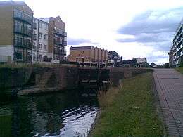 Johnson's Lock, 2008 | |
| Waterway | Regent's Canal |
|---|---|
| County |
Tower Hamlets Greater London |
| Maintained by | Canal and River Trust |
| Fall | 8 feet (2.4 m) |
| Distance to Limehouse Basin | 0.63 miles (1.0 km) |
| Distance to Paddington Basin | 8.3 miles (13.4 km) |
| Coordinates | 51°31′11″N 0°02′11″W / 51.519707°N 0.036335°WCoordinates: 51°31′11″N 0°02′11″W / 51.519707°N 0.036335°W |
Johnson's Lock is a lock on the Regent's Canal, between Mile End and Stepney in the London Borough of Tower Hamlets.
The nearest London Underground stations are Mile End and Stepney Green.
See also
| Next lock upstream | Regent's Canal | Next lock downstream |
| Mile End Lock No. 9 |
Johnson's Lock Grid reference: TQ364813 |
Salmon Lane Lock No. 11 |
References
This article is issued from Wikipedia - version of the 11/4/2016. The text is available under the Creative Commons Attribution/Share Alike but additional terms may apply for the media files.