June 2008 tornado outbreak sequence
 A tornado in Will County, Illinois on June 7. | |
| Type | Tornado outbreak |
|---|---|
| Duration | June 3–11, 2008 |
| Tornadoes confirmed | 192 confirmed |
| Max rating1 | EF4 tornado |
| Duration of tornado outbreak2 | 8 days, 16 hours, 17 minutes |
| Damage | $146.9 million (2008 USD)[1] |
| Casualties | 7 fatalities (+ 13 non–tornadic), 84 injuries |
| Areas affected | Central and Eastern United States |
|
1Most severe tornado damage; see Enhanced Fujita scale 2Time from first tornado to last tornado | |
The June 2008 tornado outbreak sequence was a series of tornado outbreaks affecting most of central and eastern North America from June 3–11, 2008. 192 tornadoes were confirmed, along with widespread straight–line wind wind damage. Seven people were killed from a direct result of tornadoes; four in Iowa, two in Kansas, and one in Indiana. Eleven additional people were killed across five states by other weather events including lightning, flash flooding, and straight-line winds. Severe flooding was also reported in much of Indiana, Wisconsin, Minnesota and Iowa as a result of the same thunderstorms, while high heat and humidity affected much of eastern North America; particularly along the eastern seaboard of the United States from New York City to the Carolinas.
Meteorological synopsis
June 3
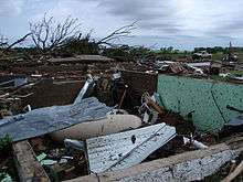
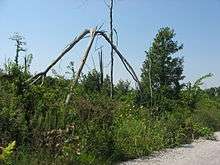
Several clusters of thunderstorms developed during the morning from eastern Nebraska across Iowa into Illinois, taking place along a warm front. The front remained over the same areas during the day, as daytime heating and southwesterly surface winds brought warm and unstable air northward, resulting in severe weather development. The presence of strong winds aloft aided in development of multiple clusters and lines of thunderstorms that produced damaging wind, hail and tornadoes across Missouri, Illinois and Indiana.[2]
A moderate risk of severe weather was issued by the Storm Prediction Center for parts of Indiana, Kentucky, Illinois, Ohio and West Virginia on June 3,[3] Two particular tornadoes, rated EF2 and EF3 on the Enhanced Fujita Scale, caused extensive damage across portions of central Indiana.[4] The EF3 tornado damaged 34 structures in Rush County, of which 27 of them were in Middletown. Eight people were injured in Rush County, including a 67-year-old woman who was impaled in the chest by a large tree limb and later died as a result of her injury on August 17.[5] A 19th century landmark covered bridge in Moscow was destroyed,[6] as well as severe damage to dozens of homes, including some that were swept completely off the foundation. The EF2 tornado damaged 20 to 30 homes in Brown County, 40 buildings at Camp Atterbury in Johnson County and 59 buildings in Edinburgh.[5]
June 4
A moderate risk of severe weather was issued for northern Kansas into southern Nebraska and from eastern West Virginia through Virginia, Maryland and Delaware.[7] An ongoing line of thunderstorms moved east across West Virginia as the atmosphere began to destabilize. The thunderstorms resulted in a threat for isolated tornadoes in eastern sections of West Virginia, Virginia, Delaware and Maryland. In the central Great Plains region, a warm front extended northeast in northeastern Kansas from a surface low in central sections of Kansas. Strong instability occurred in the vicinity of the area as a result of surface heating. An intensifying low-level jet stream broke the cap in the region and resulted in the development of thunderstorms.[8] During the afternoon, numerous thunderstorms formed across the Mid-Atlantic States. An EF0 tornado was produced from one of the thunderstorms that impacted portions of Chesapeake Beach, tearing off sections of roof and siding from 10 to 20 single family homes. EF1 tornadoes were produced in Culpeper, Clarke and Stafford counties in Virginia.[9] Several other EF0 and EF1 tornadoes formed throughout the Great Plains region.[10][11]
June 5

A strong jet stream moved northeast across the Great Plains region and a strong surface low in western Kansas strengthened as it moved to the Nebraska-South Dakota border. Ahead of the low, very warm and moist air spread throughout the South Central United States into Nebraska, eastern sections of South Dakota and the upper Mississippi Valley. The combination of strong winds and warm and moist air created conditions favorable for strong thunderstorms.[12] On June 5, a high risk of severe weather was issued for six different states in the Midwestern United States, with a moderate risk area surrounding the high risk area.[13] Forecasters had warned of a potentially historic outbreak, as computer forecasting models for June 5 resembled those on June 8, 1974, when 39 tornadoes struck the southern Great Plains and killed 22 people. Wichita State University canceled evening classes because of the weather predictions.[14] Severe weather began developing across eastern Colorado and northwestern Kansas during the morning and into the early afternoon, producing several weak tornadoes in the process.[15] An EF1 tornado impacted a campground near Kellogg, Iowa and injured two people. Despite extremely favorable conditions, severe weather for the day was limited and the tornadoes generally caused minimal damage.[16]
June 6
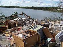
During the morning hours of June 6, two strong tornadoes caused damage throughout Wadena and Hubbard counties in Minnesota. The first tornado, rated EF2 on the Enhanced Fujita Scale, touched down south of Stocking Lake and downed several trees onto cabins, vehicles and storage sheds. It also toppled an irrigation system in a field north of the lake. The tornado moved to the north and expanded to its maximum width of 450 yards (410 m) and reached estimated peak winds of 130 miles per hour (210 km/h). Eight turkey barns were destroyed, killing an estimated 15 to 20 thousand turkeys. The tornado swept a home north of the area in Hubbard County off its foundation, as well as causing damage to several homes along with hundreds of acres of forest.[17] One man working at a turkey barn was injured.[18] The storm then produced an EF3 tornado, which eventually grew to a width of 400 yards (370 m) and reached wind speeds of 160 miles per hour (260 km/h). At Pickerel Lake, it nearly flattened every tree in the area, while destroying a trailer home, a camper, a garage and a house. At northern sections of Pickerel Lake, one home had its roof torn off and numerous trees were snapped onto other residences and farm buildings. The tornado began to lose its intensity but continued to topple trees, damage storage structures and toss debris before dissipating in Emmaville.[17]
June 7–8
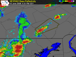
A series of impulses moved from the central Rocky Mountains into the central Great Plains. Opulent moisture formed over the Missouri and Mississippi Valleys with dew points reaching near 70 °F (21 °C). Strong low level winds over the area created favorable wind shear for supercells.[19] During the afternoon, a supercell developed in western portions of Illinois and moved northeast reaching Lake Michigan around the Illinois-Indiana border, during which it produced eight tornadoes along its path.[20] At 4:21 pm (2121 UTC), an EF0 tornado occurred 4 miles (6.4 km) east of Cornell in Livingston County. The tornado occurred in an open field with no damage observed. At 4:31 pm CDT (2131 UTC), an EF1 tornado touched down southwest of Dwight in Livingston County, snapping power poles and damaging trees and roofs; this tornado lifted at 4:45 pm CDT (2145 UTC). From 5:18 pm CDT (2218 UTC) to 5:46 pm CDT (2246 UTC), an EF2 tornado traveled 13.6 miles (21.9 km) across southwestern Will County and extreme northwestern Kankakee County, near Wilmington, uprooting trees, damaging homes and destroying sheds. At 5:51 pm CDT (2251 UTC), an EF2 tornado touched down for three minutes in central Will County near Wilton Center, destroying a garage and severely damaging a metal building. From 5:55 pm CDT (2255 UTC) to 6:08 pm CDT (2308 UTC), an EF2 tornado occurred west of Monee, leveling barns, garages, and outbuildings and damaging homes. An EF2 tornado re-formed at 6:13 pm CDT (2313 UTC), injuring six people as it crossed Interstate 57.[21]
As the tornado moved into more densely populated southern Cook County, it destroyed homes in Richton Park, before dissipating at 6:30 pm CDT (2330 UTC). At approximately 6:32 pm CDT (2332 UTC), an EF0 tornado hit South Chicago Heights, causing minor damage to several homes, with two homes sustaining significant damage. At 6:49 pm CDT (2349 UTC), an EF0 tornado touched down in Lansing, damaging tree limbs.[21] In Wisconsin, five people suffered minor injuries after an EF2 tornado went through Columbia County.[22] Further west, a new complex of storms produced two tornadoes inside the Omaha metropolitan area during the early hours of June 8.[23] A total of 539 homeowners reported damage from the tornadoes. Seven homes were destroyed and 21 others sustained major damage.[24] The two tornadoes that hit the region were rated EF1 and EF2.[23] The EF2 tornado was the strongest to strike the Omaha metropolitan area since 1975.[25]
June 11
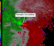
A storm system moved to the northern and central Great Plains region during the day, as strong winds helped push a moist air mass northward ahead of the system. Thunderstorms developed during the afternoon ahead of a cold front from southeast South Dakota into central Kansas. Strong winds along with instability in the atmosphere created favorable conditions for supercell development with the potential to produce strong tornadoes.[26] At approximately 6:35 pm CDT (2335 UTC)[27] a tornado hit the Little Sioux Scout Ranch in Little Sioux, Iowa, killing four Boy Scouts after a chimney collapsed on them[28] and injuring 48 others.[29] The camp received a tornado warning 12 minutes before it struck.[27] There were 93 campers and 25 staff members at the camp. The campers were between 13 and 18 years old and were attending a leadership training camp. The tornado was rated EF3 on the Enhanced Fujita Scale.[29]
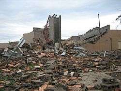
Tornadoes also caused major damage in Kansas. In Chapman, one person was killed and three others were critically injured[30] after an EF3 tornado struck the town. About 80 percent of Chapman suffered serious damage,[31] with minor damage occurring to the downtown area.[32] 70 homes in Chapman were destroyed with 215 receiving damage. Two churches were demolished and the town's elementary, middle and high schools were severely damaged.[33] Manhattan was also heavily impacted by a tornado that was rated EF4 on the Enhanced Fujita Scale. Forty-five residences in Manhattan were destroyed, as well as two mobile homes and three businesses. An additional 67 residences, three multi-family homes, one mobile home and 10 businesses suffered significant damage. Also, 75 single-family residences, three multi-family structures and 20 businesses sustained minor damage, and 637 residences, 93 multi-family structures, 20 mobile homes and 10 businesses were partially affected. An elementary school was also heavily damaged in Manhattan.[34] There was also damage to Kansas State University, where the Wind Erosion Lab was damaged. Also suffering severe damage was the engineering complex, the Sigma Alpha Epsilon fraternity house, Waters, Call and Cardwell halls as well as Ward Hall, which houses the university's nuclear reactor.[35][36] One person was also killed near the town of Soldier in Jackson County from an EF2 tornado.[33] 32 homes were damaged in Jackson County.[37] The southern outskirts of Salina near the junction of Interstate 135 was also hard hit by an EF3 tornado. Several homes, outbuildings, trees and power lines were damaged in the area.[38]
Confirmed tornadoes
| EF0 | EF1 | EF2 | EF3 | EF4 | EF5 | Total |
|---|---|---|---|---|---|---|
| 109 | 63 | 14 | 5 | 1 | 0 | 192 |
- Note: Four tornadoes in Canada were rated according to the Fujita scale, but are included in the table using their corresponding number rating.
Non–tornadic events
On June 3, the communications tower at a courthouse in Shelbyville, Missouri was struck by lightning, damaging computers for the 911 system and the sheriff's office, radio consoles, and various other electronic equipment.[39] In Oklahoma, high winds in excess of 80 miles per hour (130 km/h) caused major damage to five to six barns in Cherokee and destroyed one barn in Ingersoll.[40] Three people were injured in Frontenac, Kansas after a tree was blown down on a vehicle.[41] The next day, the inclement weather moved into the Mid-Atlantic States. A 57-year-old man was killed in Annandale, Virginia after a large tree crushed his vehicle. More than 250,000 customers lost power in Virginia.[42] Washington Monument State Park suffered extensive damage after thunderstorms knocked out phone, electricity, and water service. Fallen trees and branches blocked the main road and the hiking trail to the monument in several places. The museum and water treatment buildings were severely damaged, and as a result, the park was closed for two weeks.[43] A total 70 severe thunderstorm, marine, and tornado warnings were issued in the Baltimore/Washington region.[44] In Bloomington, Indiana, two people had lightning strikes near them and were taken to the hospital for lighting related injuries. The cell phone of another individual was stuck while the person was talking on the phone and was also taken to the hospital for treatment.[45]
On June 5, a storm system caused damage throughout the Great Plains. The most substantial damage occurred in Altus, Oklahoma, where 179 homes sustained some form of damage, with two destroyed, five with major damage, 43 with minor damage and 129 affected. Seventeen businesses were damaged, with two destroyed, four with major damage and eight with minor damage.[40] A school in Mulvane, Kansas had roof damage and there was significant roof damage to the terminal building at an airport near Winfield.[46] In Lawrence, The Wakarusa Music and Camping Festival shut down while the storm passed through.[47] On June 8, thunderstorms affected areas across the Great Lakes region.[48] Two people were killed in Ottawa County, Michigan due to the straight-line winds that toppled trees; one onto a pedestrian and another onto a car. In Eaton County, a woman was killed by winds which blew a large trailer on to her.[49] Over 300,000 people in Michigan were left without power due to the storm.[50][51]
On June 10, a powerful squall line of thunderstorms with embedded supercells developed across New York and moved northeast through parts of northern New England and Quebec. Particularly hard hit was the Montreal region and its southern suburbs including Longueuil, Châteauguay, Brossard and Saint-Jean-sur-Richelieu. Barns were reported damaged and other structures sustained roof and siding damage; particularly in the Saint-Blaise-sur-Richelieu area where one home was pushed from its foundation.[52] In Sainte-Catherine, the roof of an office was blown into a nearby residence punching a large hole on the back wall. On Montreal's Champlain Bridge, eight tractor trailers were overturned forcing the closure of the entire bridge in both directions. In addition, a window washing platform tumbled from a high rise building in downtown Montreal. The workers were able to get inside.[53]

Severe thunderstorms also affected the Saint-Hyacinthe, Sherbrooke, Trois-Rivières and Quebec City where winds as strong as 68 miles per hour (109 km/h) were reported with locally higher gusts while hail from golf ball to baseball size were reported in Mont-Saint-Hilaire and Belœil breaking windows from homes and vehicles.[54] The roof of a 65 unit apartment complex in Sainte-Foy was heavily damaged. The Quebec Bridge linking the city to the suburb of Levis was also temporarily shut down because of a collapsed scaffolding.[55] About 300,000 Hydro-Québec customers across the province lost power, particularly in the Quebec City, Montérégie and Montreal regions with outages occurring in the Eastern Townships and Mauricie regions. Schools in some areas were closed on June 11 due to the power outages.[56] The tractor trailer accidents resulted in two minor injuries during the storms.[57] According to a report from the Insurance Bureau of Canada, insured damage amounts were estimated at $56 million (2008 CAD), and up to 16,000 insurance claims were filed for damage to homes and automobiles.[58]
The severe weather extended south into the Eastern Seaboard of the United States where it ended a prolonged period of intense heat. Temperatures had reached the mid to upper 90s °F (mid 30s °C) for several days in a row, with some areas exceeding 100 °F (38 °C). About 150,000 customers in New Jersey, 140,000 in Pennsylvania and 50,000 in northern New York lost power.[59] One person was killed in Lewis County, New York by fallen trees during the storm.[60]
Flooding
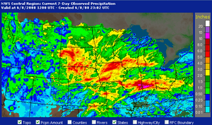
The same series of systems contributed to a significant flooding event in many parts of the Midwest. Several counties in this region in Iowa, Illinois and Wisconsin were declared disaster areas. Over 10 inches (25 cm) fell in areas over the course of a week, and in Indiana some rivers approached levels similar to flooding in 1913 which killed 200 people.[61] In Franklin, Indiana, water at one point reached the first level of the area hospital, and buildings at Franklin College were damaged. Flooding was reported also in Columbus, Helmsburg and Terre Haute, Indiana. US Coast Guard units were deployed in assistance for rescue efforts. Parts of Interstate 65 and U.S. Route 31 were temporarily shut down. Thirty thousand people in Indiana lost power during the storms, and several counties filed disaster declarations.[62]

Beginning on June 8, flooding also started occurring across parts of Iowa following several round of thunderstorms and heavy rains. In Parkersburg, Iowa, a levee burst, flooding three nearby highways. In New Hartford, which was also hit by the same tornado, water gushed over a levee forcing the evacuation of 650 people.[63] The flood waters also damaged a water treatment plant leaving Mason City without drinking water. Up to 5 inches (13 cm) of rain fell in parts of the state.[64] Mandatory evacuations were also made in Cedar Falls and Waterloo.[65] Several entire blocks in Cedar Rapids were under water (which was at times as high as stop signs) after the Cedar River overflowed its banks.[66] Flooding later affected the Iowa City area along the Iowa River where 20 buildings on the University of Iowa campus were affected.[67] Many other towns across the state became flooded as well as the rising water levels slowly made their way into the Mississippi River across southeastern Iowa, western Illinois and northeastern Missouri.[68]
Flooding was also reported north of Mason City in southeastern Minnesota, where several inches of rain closed roads and forced evacuations. Gays Mills, Wisconsin was evacuated for the second time in ten months when the Kickapoo River flooded the town. These same areas were also affected by the 2007 Midwest flooding.[69][70] From June 3 to June 11 eight people were killed due to flooding; three in Indiana,[71] three in Michigan,[49] and one in Illinois and Minnesota.[72][73]
See also
References
- ↑ "Storm Event Database". National Climatic Data Center. Retrieved January 4, 2015.
- ↑ "Severe Thunderstorms Expected from Missouri eastward into Ohio Later Today and Tonight". Storm Prediction Center. 2008-06-03. Retrieved 2009-03-02.
- ↑ "Jun 3, 2008 1630 UTC Day 1 Convective Outlook". Storm Prediction Center. 2008-06-03. Retrieved 2008-06-09.
- ↑ "Midwest Weekly Highlights - June 1–9, 2008". Midwestern Regional Climate Center. 2008-06-09. Retrieved 2009-02-03.
- 1 2 "Storm data and unusual weather phenomena - June 2008". FindArticles. 2008. Retrieved 2009-02-06.
- ↑ Tribune wire reports (2008-06-04). "Moscow, Indiana tornado". Chicago Tribune. Retrieved 2008-06-09.
- ↑ "Jun 4, 2008 1630 UTC Day 1 Convective Outlook". Storm Prediction Center. 2008-06-04. Retrieved 2009-05-06.
- ↑ "Severe Thunderstorms Expected Over Parts of the Central Plains and Mid Atlantic Region this Afternoon and Tonight". Storm Prediction Center. 2008-06-04. Retrieved 2009-05-05.
- ↑ "Storm Data and Unusual Weather Phenomena - June 2008" (PDF). National Weather Service Baltimore/Washington, D.C. Retrieved 2009-05-06.
- ↑ "Storm Data and Unusual Weather Phenomena - June 2008". FindArticles. 2008. Retrieved 2009-05-06.
- ↑ "2 More Tornadoes Confirmed in Nebraska". KOLN. Associated Press. 2008-06-06. Retrieved 2009-05-10.
- ↑ "Severe Thunderstorm Outbreak Expected from the Eastern Half of the Plains into the Upper Mississippi Valley this Afternoon and Tonight". Storm Prediction Center. 2008-06-05. Retrieved 2009-05-09.
- ↑ "Jun 5, 2008 1300 UTC Day 1 Convective Outlook". Storm Prediction Center. 2008-06-05. Retrieved 2009-05-09.
- ↑ Lampe, Nelson (2008-06-05). "Severe storms begin to batter Plains". USA Today. Retrieved 2008-06-08.
- ↑ "Storm Data and Unusual Weather Phenomena - June 2008". FindArticles. 2008. Retrieved 2009-05-10.
- ↑ "Storm Data and Unusual Weather Phenomena - June 2008". FindArticles. 2008. Retrieved 2009-05-10.
- 1 2 "Tornado Impacts in Wadena and Hubbard Counties – June 6, 2008". National Weather Service Grand Forks, North Dakota. 2008-06-11. Retrieved 2009-05-11.
- ↑ Shaffer, David (2008-06-07). "Storms create long weekend to-do list for northern Minnesota". Star Tribune. Retrieved 2009-05-11.
- ↑ "Severe Thunderstorms Expected over Parts of the Central Plains into the Upper Mississippi Valley Later Today and Tonight". Storm Prediction Center. 2008-06-07. Retrieved 2009-05-12.
- ↑ "Storm Data and Unusual Weather Phenomena - June 2008" (PDF). National Weather Service Chicago, Illinois. Retrieved 2009-05-12.
- 1 2 "Results from Storm Surveys of June 7th Tornadoes". National Weather Service Chicago, Illinois. 2008-06-11. Retrieved 2009-05-12.
- ↑ "Residents Contend With Widespread Flooding, Tornado Damage". WISC-TV. 2008-06-10. Retrieved 2009-05-15.
- 1 2 "EF1 and EF2 Tornadoes Hit Portions of Omaha Metro 6/8/08-Updated". National Weather Service Omama/Valley, Nebraska. 2008-06-09. Retrieved 2009-05-15.
- ↑ Sloan, Karen (2008-06-14). "Omaha tornado cleanup progressing". Omaha World-Herald. Retrieved 2009-05-15.
- ↑ "Heineman stunned by Millard damage". Omaha World-Herald. 2008-06-09. Retrieved 2008-06-09.
- ↑ "Severe Thunderstorms Expected Over Parts of the Corn Belt and Mid-Missouri River Valley later Today and Tonight". Storm Prediction Center. 2008-06-11. Retrieved 2009-05-18.
- 1 2 Robynn, Tvsver; Elfrink, T.; Nelson, A. (2008-06-12). "Four killed, 42 injured at Iowa Boy Scout camp". Omaha World-Herald. Retrieved 2009-05-16.
- ↑ Hytrek, Nick (2008-06-12). "Lawton teen survives brush with death". Sioux City Journal. Retrieved 2009-05-16.
- 1 2 NBC News and news services (2008-06-12). "Scouts recount terror, heroics during twister". MSNBC. Retrieved 2009-05-16.
- ↑ "4 dead, 48 injured as tornado hits Iowa Boy Scout camp". Minnesota Public Radio. Associated Press. 2008-06-12. Retrieved 2009-05-16.
- ↑ Strand, Carla (2008-06-14). "Cleanup continues in Chapman". Abilene Reflector-Chronicle. Retrieved 2008-06-14.
- ↑ Biles, Jan (2008-06-14). "Face of Chapman scarred: Schools, homes, churches". The Topeka Capital-Journal. Retrieved 2009-05-17.
- 1 2 "Another record-breaking tornado year". The Topeka Capital-Journal. 2009-03-05. Retrieved 2009-05-17.
- ↑ Felber, Bill (2008-06-18). "Storm was an EF4 when it struck; now the focus turns to a community-wide assistance effort". Manhattan Mercury. Retrieved 2009-05-17.
- ↑ "Tornado Rips Manhattan, KSU". KMBC. 2008-06-12. Retrieved 2008-06-12.
- ↑ "Tornado Damages K-State Campus". KWCH. 2008-06-12. Retrieved 2008-06-12.
- ↑ "Tornado Damages 32 Homes, Kills Man in Jackson County, Kansas". KAKE-TV. 2008-06-12. Retrieved 2008-06-14.
- ↑ Finger, Stan (2008-06-12). "Salina tornado classified an EF3". The Wichita Eagle. Retrieved 2009-05-17.
- ↑ Hunt, Alexis (2008-06-04). "Shelby County courthouse works to get back on track". KHQA-TV. Retrieved 2009-05-22.
- 1 2 "Storm Data and Unusual Weather Phenomena - June 2008" (PDF). National Weather Service Norman, Oklahoma. Retrieved 2009-05-23.
- ↑ "Storm Data and Unusual Weather Phenomena - June 2008". FindArticles. 2008. Retrieved 2009-05-23.
- ↑ "Man Killed in Severe Weather Identified". WHSV-TV. Associated Press. 2008-06-06. Retrieved 2009-05-24.
- ↑ Velasquez, Thaisi H (2009-06-20). "Washington Monument State Park To Re-Open Friday". The Herald-Mail. Retrieved 2009-05-24.
- ↑ Livingston, Ian (2008-06-05). "Recap: June 4 Severe Weather Outbreak". Washington Post. Retrieved 2008-10-30.
- ↑ The Herald-Times staff (2008-06-05). "Flash flood leaves city awash Afternoon deluge floods roads, businesses, homes, strands many drivers". The Herald-Times via Indiana University. Retrieved 2009-05-25.
- ↑ "Damaging winds blow through southern Kansas". National Weather Service Wichita, Kansas. 2008-06-05. Retrieved 2008-09-16.
- ↑ "Storm Spawns Tornadoes, Flooding Concerns". KMBC. 2008-06-06. Retrieved 2008-06-13.
- ↑ "SPC Storm Reports for 06/08/08". National Weather Service. 2008-06-08. Retrieved 2008-06-09.
- 1 2 Hall Jr, Rex (2008-06-09). "Vicious storm claims 6 lives in Michigan". Booth Newspapers. Retrieved 2009-06-02.
- ↑ DiSavino, Scott (2008-06-11). "Some 150,000 Michigan customers still without power". Reuters. Retrieved 2008-06-13.
- ↑ "Severe Storms Strike Again". WDIV-TV. 2008-06-13. Retrieved 2008-06-13.
- ↑ "Quebec couple lost home's roof to severe storm". CTV. 2008-06-11. Retrieved 2008-06-11.
- ↑ "Champlain bridge shut after trucks tip in storm". CBC. 2008-06-10. Retrieved 2008-06-10.
- ↑ "Severe Thunderstorms and High Winds of June 10, 2008". CRIACC. 2008-06-18. Archived from the original on February 26, 2009. Retrieved 2008-06-10.
- ↑ "Toits arrachés et pannes de courant" (in French). Le Journal de Québec. 2008-06-11. Retrieved 2008-06-11.
- ↑ "Pannes d'électricité et écoles fermées" (in French). Canoe.ca. 2008-06-11. Retrieved 2008-06-11.
- ↑ "Powerful storm topples trees, trucks in Montreal". Ottawa Citizen. 2008-06-10. Retrieved 2008-06-10.
- ↑ "Violents orages du 10 juin: 56 millions $ en dommages" (in French). Cyberpresse.ca. 2008-07-02. Retrieved 2008-07-02.
- ↑ "Heat Eases; Severe Storms Today". Accuweather. 2008-06-11. Retrieved 2008-06-11.
- ↑ "Man running log-loader fatally pinned in storm". Rome Sentinel. Retrieved 2009-06-02.
- ↑ "One dead, one missing in Indiana flooding". WTHR. 2008-06-08. Retrieved 2008-06-08.
- ↑ "June Flooding: Disaster Declarations, Shelters & Road Closures". WISH-TV. 2008-06-08. Retrieved 2008-06-08.
- ↑ "New Hartford tries to recover after tornado, now a flood". Sioux City Journal. 2008-06-08. Retrieved 2008-07-19.
- ↑ "Flood waters, death toll rise after weekend storms". CNN. 2008-06-09. Retrieved 2008-06-09.
- ↑ Murray, J.J. (2008-06-19). "Downtown Cedar Falls/Waterloo Evacuate from Rising Waters". KIMT. Archived from the original on June 13, 2008. Retrieved 2008-10-08.
- ↑ "4,000 homes evacuated amid flooding in Cedar Rapids, Iowa". CNN. 2008-06-13. Archived from the original on July 6, 2008. Retrieved 2008-10-08.
- ↑ "Inside view reveals mess, standing water in UI arts buildings". GazetteOnline.com. 2008-06-19. Retrieved 2008-06-20.
- ↑ "McCain inspects Iowa flood damage". Des Moines Register. 2008-06-19. Retrieved 2008-06-20.
- ↑ "Evacuations advised due to flooding in Houston County". Minnesota Public Radio. 2008-06-08. Retrieved 2008-06-09.
- ↑ Foley, Ryan J. (Associated Press Writer) (2008-06-09). "Flash floods inundate Wis. town for 2nd time". ABC News. Archived from the original on July 2, 2008. Retrieved 2008-10-08.
- ↑ Kusmer, Ken (Associated Press Writer) (2008-06-10). "More storms as water-weary residents start recovery". USA Today. Retrieved 2009-06-04.
- ↑ Meeker, Herb (2008-06-06). "Coroner: Man drowned in his car after it plunged into river". Journal Gazette and Times-Courier. Retrieved 2009-06-02.
- ↑ Stultz, Sarah (2008-06-13). "Albert Lea man identified in flood accident". Austin Daily Herald. Retrieved 2009-06-02.
External links
- Rainfall amounts for June 6-7 in Indiana (NWS Indianapolis)
- Eastern Wisconsin rainfall amounts (NWS Milwaukee)
- Western Wisconsin rainfall amounts (NWS La Crosse)
- Storm damage image gallery from southern Quebec on June 10 (La Presse)
- Video of E4 Manhattan tornado hitting Kansas State University