Kahlheid
| Kahlheid | |
|---|---|
|
The Kahlheid with its transmission tower | |
| Highest point | |
| Elevation | 766 m above sea level (NHN) (2,513.1 ft) [1][2] |
| Coordinates | 49°44′53″N 7°06′49″E / 49.748°N 7.113556°ECoordinates: 49°44′53″N 7°06′49″E / 49.748°N 7.113556°E |
| Geography | |
 Kahlheid near Morscheid-Riedenburg; counties of Birkenfeld and Bernkastel-Wittlich, | |
| Parent range | Idar Forest (Hunsrück) |
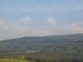
The Kahlheid near Morscheid-Riedenburg in the Idar Forest (Hunsrück) is a mountain, 766 m above sea level (NHN),[1][2] on the boundary between the counties of Birkenfeld and Bernkastel-Wittlich in the German state of Rhineland-Palatinate.
The mountain is the third highest in Rhineland-Palatinate after the Erbeskopf (816.3 m), 2.6 km to the southwest and its southwestern subpeak, the Springenkopf (784.2 m), in the Schwarzwalder Hochwald, and the peak of An den zwei Steinen (766.2 m), 12 km to the northeast (both distances as the crow flies), also in the Idar Forest.
See also
References
- 1 2 Map services of the Federal Agency for Nature Conservation
- 1 2 Map service of the Landscape Information System of the Rhineland-Palatinate Nature Conservation Office (Naturschutzverwaltung Rheinland-Pfalz)
This article is issued from Wikipedia - version of the 12/6/2015. The text is available under the Creative Commons Attribution/Share Alike but additional terms may apply for the media files.