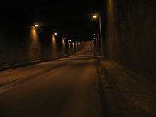
Kanonersky Tunnel
 Underwater part of a tunnel | |
| Overview | |
|---|---|
| Location | Kirovsky District of Saint-Petersburg, Russia |
| Coordinates | 59°54′13″N 30°13′28″E / 59.90361°N 30.22444°ECoordinates: 59°54′13″N 30°13′28″E / 59.90361°N 30.22444°E |
| Start | Dvinskaya street of Gutuevsky Iseland |
| End | Kanonersky Island |
| Operation | |
| Work begun | 1970[1] |
| Constructed | 1970-1983[1] |
| Opened | 29 July 1983[2] |
| Closed | 1983 (three months) |
| Owner | Saint Petersburg City Administration |
| Operator | SUE "Mostotrest"[1] |
| Traffic | Automotive |
| Character | City automobile movement |
| Vehicles per day | 1500[1] |
| Technical | |
| Length |
927 metres (3,041 ft),[3] 647 metres (2,123 ft) (between portals) |
| Number of lanes | One in each part |
| Operating speed | 60 kilometres per hour (37 mph) |
| Width | 8.5 metres (28 ft) (roadway) |
Kanonersky Tunnel (Russian: Канонерский тоннель[4]) is a tunnel under the sea canаl in the Kirovsky District of Saint-Petersburg. The tunnel provides a link between Kanonersky island and Dvinskaya street on Gutuevsky island.
History
Before 1983 the only possible way to get on the island was by ferry (it was the last ferry line of Saint Petersburg) or a private boat,[3] daily across the sea canаl which was a crossing for more than 2 million people.[5] Constantly operating the crossing was also necessary for transportation of cargoes from Big port Saint Petersburg.[1] Because of that on the Sea channel movement of courts sea-gauge to 10 metres (33 ft) and width to 40 metres (130 ft), bridge building was refused. The decision to build a tunnel was accepted.
The project was prepared by Lengiprotrans,[2] and the building work carried out by Giprostroymost.[6] Geodetic maintenance of the building is carried out by Petersburg State University of Means of Communication.[7] The Tunnel was built using a method of buried sections: in the preliminary dug trench five identical sections were laid, each of which had a length of 75 metres (246 ft) and weighed about 8,000 tonnes (8,800 short tons). This method was applied for the first time in the Soviet Union . The length of the site dipping sections totalled 375 metres (1,230 ft).
For the building of the sections on the bank of the sea canal, the original dock-sluice was constructed. After sluicing the created sections, with the end faces closed by metal partitions, they were counterbalanced by water and transported along the sea canal to the place of immersion. It fell onto tackles that were joined to an earlier established section, forming a uniform design. For the control of the immersion, divers worked underwater.[6]
After packing of designs from them have pumped out water and have built underground tunnels and portals; the full length of a tunnel was 927 metres (3,041 ft).[3] The tunnel has two lanes (on one in each part) and a footpath. Along with cables for electrical supply and communication; water supply and central heating pipes connect Kanonersky Island with the city.[8]
Operation
Periodically water gets into the tunnel, experts explain this is because of defects in the waterproofing. After a solemn opening of the tunnel, it was closed again for three months to enable completion in the 1998-2002 tunnel major repairs.[3] In 2004 Lengiprotrans again made repair work.[2] In 2006 there was a mooring damaged over the tunnel, from it the tunnel was also damaged,[9] and at the end of June, 2009 tunnel repair was again required, with the drainage system being replaced.[10]
The tunnel is not closed for repair, but movement is essentially limited. Failures in the tunnel occur seldom and because of low speeds do without victims. Elimination of the consequences can however occupy some hours.[11]
References
- 1 2 3 4 5 Уникальный ремонт подводного тоннеля на Канонерский остров через Морской канал в Санкт-Петербурге будет закончен в конце 2002 года (in Russian). Saint Petersburg, Russia: Saint Petersburg Business Guide. 2001-08-16. Retrieved 2009-11-04. External link in
|publisher=(help) - 1 2 3 "Lengiprotrans: objects" (in Russian). Russia: Lengiprotrans. Retrieved 2009-11-04.
- 1 2 3 4 Kelner, Irina; Alexei Kuznetsov (2004). Часть города / Канонерский остров [Kanonersky Island]. Адреса Петербурга [Addresses of Petersburg] (in Russian). Saint Petersburg, Russia. Retrieved 2009-11-04.
- ↑ This informal name, but it is used both inhabitants, and mass-media and state structures
- ↑ Речные переправы :: Энциклопедия Санкт-Петербурга (in Russian). Retrieved 2009-11-04.
- 1 2 Канонерский тоннель г.Санкт-Петербурге. Projects: Tunnels (in Russian). Saint Petersburg, Russia: Giprostroymost. Retrieved 2009-11-04.
- ↑ Кафедра "Инженерная геодезия" (in Russian). Saint Petersburg, Russia: Petersburg State University of Means of Communication. Retrieved 2009-11-04.
- ↑ Tumakova, Irina. К владычице морской как уплыл за границу канонерский завод (in Russian). Saint Petersburg, Russia: Lawmix.ru. Retrieved 2009-11-04.
- ↑ Timofeev, E. P. Не спекулируйте, господа (in Russian). www.1917.com. Retrieved 2009-11-04.
- ↑ Предстоящей ночью ограничат движение в Канонерском тоннеле. Roads (in Russian). Karpovka.net. 2009-06-30. Retrieved 2009-11-04.
- ↑ Фоторепортаж с места аварии в Канонерском тоннеле. Сейчас движение уже открыто. Incindents (in Russian). Saint Petersburg, Russia: fontanka.ru. 2006-10-05. Retrieved 2009-11-04. External link in
|publisher=(help)