Kieselbach (river)
| Kieselbach | |
|---|---|
|
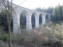
Rail viaduct over the Kieselbach in the valley Finsterer Grund | |
| Country | Germany |
| Basin | |
| Main source |
Ernstthal ca. 800 m (2,600 ft) 50°29′45.9″N 11°09′55.3″E / 50.496083°N 11.165361°E |
| River mouth |
Lichte ca. 615 m (2,018 ft) 50°31′04.9″N 11°10′38.2″E / 50.518028°N 11.177278°ECoordinates: 50°31′04.9″N 11°10′38.2″E / 50.518028°N 11.177278°E |
| Basin size | 1 km2 (0.39 sq mi) |
| Physical characteristics | |
| Length | 4 km (2.5 mi) |
The Kieselbach is a right tributary of the Lichte in Thuringia, Germany, and is 4 km long.
Sources
The Kieselbach rises in Ernstthal (city quarter of Lauscha) close to the Rennsteig, the watershed between Franconia and Thuringia in the Thuringian Highlands.
Course
The Kieselbach source is close to the rail station Ernstthal am Rennsteig. On its way northeast through the Nature Park Thuringian Forest, the Kieselbach flows first through the Finsterer Grund (Dark Valley), where a now closed section of the Sonneberg – Probstzella single-track railway line passes over it on a viaduct. Finally it reaches the housing estate Waschdorf (western municipality part of Lichte). In Waschdorf it unites with the Little Lichte and follows as Lichte River further the Lichte Valley to the Leibis-Lichte Dam and to the mouth into the Schwarza (Saale).
References
- Albert Broedel, A contribution to the history of the Lichte Municipality composed as to official sources 1937 – 1939; issued by W. Broedel, Kulmbach, March 7, 1997.