Kilkenny (Richmond Hill, Georgia)
|
Kilkenny | |
 | |
  | |
| Nearest city | Richmond Hill, Georgia |
|---|---|
| Coordinates | 31°47′24″N 81°12′12″W / 31.78995°N 81.20339°WCoordinates: 31°47′24″N 81°12′12″W / 31.78995°N 81.20339°W |
| Area | 1 acre (0.40 ha) |
| NRHP Reference # | 79000700[1] |
| Added to NRHP | February 14, 1979 |
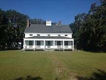
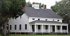
Kilkenny (pronounce “Kill-Cainey”) was the 662 acre pre-American Revolutionary War property of Thomas Young (1733-1808) from about 1758 and was later used as the site of the Kilkenny Club. The executors of Young’s estate sold Kilkenny to Charles Rogers of Savannah and Sapelo Island on January 21, 1836. The land was used to raise Sea Island cotton. The property fronts the Kilkenny River and overlooks tidal salt marsh out towards Ossabaw, the St. Catherines Islands and Ossabaw Islands, with access to St. Catherines Sound. Rogers built a wooden frame house ca. 1845 that still exists. A Union gunboat shelled the property from the Bear River during the U.S. Civil War.[2]
After the Civil War Kilkenny plantation was purchased by James M. Butler in 1874. It was then acquired by James H. Furber in January 1890 and the Kilkenny Club was established. In 1889 a well was drilled.[2]
The property was owned by Former Tennessee governor John Cox and Henry Ford (June 1930). Ford restored it. Ford also restored the structures that had been used as slave cabins, but they were later demolished.[2]
It was added to the National Register of Historic Places on February 14, 1979. It is located east of Richmond Hill, Georgia on Kilkenny Road.
See also
References
- ↑ National Park Service (2010-07-09). "National Register Information System". National Register of Historic Places. National Park Service.
- 1 2 3 Coastal Bryan Heritage Trail Richmond Hill, Georgia