Killymoriarty
Killymoriarty (from Irish: Coill Uí Mhuireartaigh, meaning 'Moriarty's Wood', local pronunciation is Kill-a-Morritty) is a townland in the civil parish of Templeport, County Cavan, Ireland. It lies in the Roman Catholic parish of Templeport and barony of Tullyhaw.
Geography
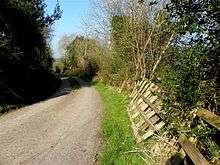
Killymoriarty is bounded on the north by Ray, Templeport townland, on the west by Gortaclogher townland, on the south by Killywillin townland and on the east by Porturlan townland. Its chief geographical features are Templeport Lough, Killywillin Lough, a stream, spring wells and dug wells. Killywillin is traversed by minor roads, rural lanes and the disused Cavan and Leitrim Railway.
The townland covers 161 statute acres.[1]
History
The 1609 Baronial Map depicts the townland as Kilmuriertagh.[2] [3]
The 1665 Down Survey map depicts it as Killymoreat.[4]
William Petty's 1685 map depicts it as Killneratt.
In the Plantation of Ulster by grant dated 29 April 1611, along with other lands, King James VI and I granted one poll of Killmuriertagh to the McGovern Chief, Phelim Magawran, but it is probable that the lands had been in the possession of the McGovern clan for several hundred years before this and it was just a Surrender and regrant confirming the existing title to the McGoverns.
An Inquisition of King Charles I of England held in Cavan town on 4 October 1626 stated that the aforesaid Phelim Magawrane died on 20 January 1622 and his lands, including one poll of Killmoriertagh, went to his son Brian who was aged 30 (born 1592) and married.
The McGovern lands in Killymoriarty were confiscated in the Cromwellian Act for the Settlement of Ireland 1652 and were distributed as follows-
In the Hearth Money Rolls of 1662 there was one person paying the Hearth Tax in Kilmurty- John Davies.
A grant dated 30 January 1668 was made from King Charles II of England to John Davies of two cartrons in Killmoreta being 35 acres profitable and 9 acres 1 rood and 6 perches unprofitable.
The Tithe Applotment Books for 1827 list thirteen tithepayers in the townland.[5]
Griffith's Valuation of 1857 lists twenty one landholders in the townland.[6]
In the 1901 census of Ireland, there are six families listed in the townland,[7] and in the 1911 census of Ireland, there are still six families listed in the townland.[8]
Antiquities
The chief structures of historical interest in the townland are:
References
- ↑ "IreAtlas". Retrieved 29 February 2012.
- ↑ National Archives Dublin:
- ↑
- ↑ Trinity College Dublin: The Down Survey of Ireland.
- ↑ and and in the Tithe Applotment Books 1827
- ↑
- ↑
- ↑ Census of Ireland 1911
- ↑ Site number 47 in “Archaeological Inventory of County Cavan”, Patrick O’Donovan, 1995
- ↑ Site number 67 in “Archaeological Inventory of County Cavan”, Patrick O’Donovan, 1995
- ↑ Site number 784 in “Archaeological Inventory of County Cavan”, Patrick O’Donovan, 1995
External links
Places in County Cavan | ||
|---|---|---|
| Towns | 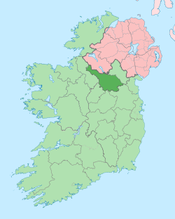 | |
| Villages |
| |
| Townlands | ||
| Landforms | ||
| ||
Coordinates: 54°04′31″N 7°48′37″W / 54.07514°N 7.810271°W