Kuntur Wayi
This article is about the mountain in the Ancash Region, Peru. For other uses, see Kuntur Wayi.
| Kuntur Wayi | |
|---|---|
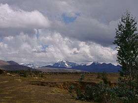 Kuntur Wayi (on the left), Wallanka and Tankanqucha | |
| Highest point | |
| Elevation | 5,171 m (16,965 ft) [1] |
| Coordinates | 9°56′24″S 77°02′33″W / 9.94000°S 77.04250°WCoordinates: 9°56′24″S 77°02′33″W / 9.94000°S 77.04250°W |
| Geography | |
 Kuntur Wayi Peru | |
| Location | Peru, Ancash, Bolognesi Province |
| Parent range | Wallanka |
Kuntur Wayi or Kuntur Wayin (Quechua kuntur condor, Ancash Quechua wayi house,[2] "condor house", also spelled Condorhuayi, Condor-Huain)[3][4] is a 5,171-metre-high (16,965 ft) mountain in the Wallanka mountain range in the Andes of Peru. It is situated in the Ancash Region, Bolognesi Province, on the border of the districts of Aquia and Huallanca. Kuntur Wayi lies east of the Minapata valley, southwest of Kunkush, south of Wallanka and southeast of Minapata.[1][3]
Sources
- 1 2 "Cerro Condorhuayi". IGN, Peru. Retrieved March 15, 2015.
- ↑ Leonel Alexander Menacho López, Yachakuqkunapa Shimi Qullqa, Anqash Qhichwa Shimichaw (Ministerio de Educación), Wordbook Ancash Quechua-Spanish
- 1 2 escale.minedu.gob.pe - UGEL map of the Bolognesi Province (Ancash Region)
- ↑ Alfred J. Bodenlos, George E. Ericksen, Lead-Zing Deposits of Cordillera Blanca and Northern Cordillera Huayhuash, Peru, Geological Survey Bulletin 1017, see. sketch maps p.9-10
This article is issued from Wikipedia - version of the 5/15/2016. The text is available under the Creative Commons Attribution/Share Alike but additional terms may apply for the media files.