Louisiana Highway 37
| ||||
|---|---|---|---|---|
 | ||||
| Route information | ||||
| Maintained by Louisiana DOTD | ||||
| Length: | 42.7 mi[1] (68.7 km) | |||
| Major junctions | ||||
| South end: | Wooddale Boulevard in Baton Rouge | |||
  US 61 / US 190 in Baton Rouge US 61 / US 190 in Baton Rouge.svg.png) LA 64 in Central LA 64 in Central.svg.png) LA 63 in Grangeville LA 63 in Grangeville | ||||
| North end: |
.svg.png) LA 10 in Greensburg LA 10 in Greensburg | |||
| Location | ||||
| Parishes: | East Baton Rouge, East Feliciana, St. Helena | |||
| Highway system | ||||
| ||||
.svg.png)
.svg.png)
.svg.png)
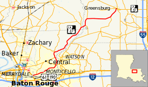
Louisiana Highway 37 (LA 37) is a 42.7-mile-long (68.7 km) north-south state highway in Louisiana, United States, extending from Wooddale Boulevard in Baton Rouge to Louisiana Highway 10 in Greensburg.[1] In East Baton Rouge Parish, the highway is named Greenwell Springs Road.
Major junctions
| Parish | Location | mi[1] | km | Destinations | Notes |
|---|---|---|---|---|---|
| East Baton Rouge | Baton Rouge | 0.0 | 0.0 | Greenwell Springs Road / Wooddale Boulevard | |
| 0.1– 0.4 | 0.16– 0.64 | US 61 / US 190 (Airline Highway) – Natchez, MS, Opelousas | Interchange | ||
| 1.7 | 2.7 | .svg.png) LA 946 north (Joor Road) / Oak Villa Boulevard LA 946 north (Joor Road) / Oak Villa Boulevard | Southern terminus of LA 946 | ||
| Central | 9.2 | 14.8 | .svg.png) LA 64 east (Magnolia Bridge Road) / LA 3034 west LA 64 east (Magnolia Bridge Road) / LA 3034 west | Southern end of LA 64 concurrency; eastern terminus of LA 3034 | |
| 12.1 | 19.5 | .svg.png) LA 408 west (Hooper Road) LA 408 west (Hooper Road) | Eastern terminus of LA 408 | ||
| 14.2 | 22.9 | LA 64 west – Pride | Northern end of LA 64 concurrency | ||
| East Feliciana | | 27.4 | 44.1 | LA 63 north – Clinton | Southern end of LA 63 concurrency |
| St. Helena | Grangeville | 28.8 | 46.3 | LA 63 south – Pine Grove, Denham Springs | Northern end of LA 63 concurrency |
| | 31.5 | 50.7 | .svg.png) LA 448 north LA 448 north | Southern terminus of LA 448 | |
| | 38.9 | 62.6 | .svg.png) LA 449 south – Pine Grove, Denham Springs LA 449 south – Pine Grove, Denham Springs | Northern terminus of LA 449 | |
| Greensburg | 42.6 | 68.6 | .svg.png) LA 1042 (South Main Street) LA 1042 (South Main Street) | ||
| 42.7 | 68.7 | LA 10 | |||
1.000 mi = 1.609 km; 1.000 km = 0.621 mi
| |||||
References
- 1 2 3 Google (January 3, 2015). "Louisiana Highway 37" (Map). Google Maps. Google. Retrieved January 3, 2015.
This article is issued from Wikipedia - version of the 11/27/2016. The text is available under the Creative Commons Attribution/Share Alike but additional terms may apply for the media files.