Laarbeek
| Laarbeek | |||
|---|---|---|---|
| Municipality | |||
|
| |||
| |||
.svg.png) Location in North Brabant | |||
| Coordinates: 51°32′N 5°38′E / 51.533°N 5.633°ECoordinates: 51°32′N 5°38′E / 51.533°N 5.633°E | |||
| Country | Netherlands | ||
| Province | North Brabant | ||
| Established | 1 January 1997[1] | ||
| Government[2] | |||
| • Body | Municipal council | ||
| • Mayor | Frans Ronnes (CDA) | ||
| Area[3] | |||
| • Total | 56.17 km2 (21.69 sq mi) | ||
| • Land | 55.37 km2 (21.38 sq mi) | ||
| • Water | 0.80 km2 (0.31 sq mi) | ||
| Elevation[4] | 14 m (46 ft) | ||
| Population (May 2014)[5] | |||
| • Total | 21,890 | ||
| • Density | 395/km2 (1,020/sq mi) | ||
| Time zone | CET (UTC+1) | ||
| • Summer (DST) | CEST (UTC+2) | ||
| Postcode | 5735–5741 | ||
| Area code | 0492, 0499 | ||
| Website |
www | ||
Laarbeek (![]() pronunciation ) is a municipality located in the province of North Brabant in the south of the Netherlands. It was formed in 1997 from the former municipalities Beek en Donk, Aarle-Rixtel and Lieshout (which included the village Mariahout). Laarbeek is part of the city region 'Samenwerkingsverband Regio Eindhoven', centered on the city of Eindhoven. The town hall is located in Beek en Donk.
pronunciation ) is a municipality located in the province of North Brabant in the south of the Netherlands. It was formed in 1997 from the former municipalities Beek en Donk, Aarle-Rixtel and Lieshout (which included the village Mariahout). Laarbeek is part of the city region 'Samenwerkingsverband Regio Eindhoven', centered on the city of Eindhoven. The town hall is located in Beek en Donk.
Lieshout is home of the Bavaria Brewery, one of the Netherlands' largest breweries which produces for local and foreign markets.
The Croy Castle is located near the village Aarle-Rixtel.
Population centres
- Achterbosch
- Beemdkant
- Broek
- De Hei
- Deense Hoek
- Ginderdoor
- Groenewoud
- Heikant
- Het Hool
- Het Laar
- 't Hof
- Kruisschot
- Scheepstal
- Strijp
- Wolfsputten
Topography

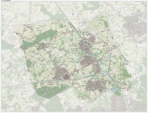
Dutch Topographic map of the municipality of Laarbeek, June 2015.
References
- ↑ "Gemeentelijke indeling op 1 januari 1997" [Municipal divisions on 1 January 1997]. cbs.nl (in Dutch). CBS. Retrieved 29 May 2014.
- ↑ "Waarnemend burgemeester F.H.G.M Ronnes" [Acting mayor F.H.G.M Ronnes] (in Dutch). Gemeente Laarbeek. Retrieved 24 January 2015.
- ↑ "Kerncijfers wijken en buurten" [Key figures for neighbourhoods]. CBS Statline (in Dutch). CBS. 2 July 2013. Retrieved 12 March 2014.
- ↑ "Postcodetool for 5741GA". Actueel Hoogtebestand Nederland (in Dutch). Het Waterschapshuis. Retrieved 29 May 2014.
- ↑ "Bevolkingsontwikkeling; regio per maand" [Population growth; regions per month]. CBS Statline (in Dutch). CBS. 26 June 2014. Retrieved 24 July 2014.
External links
 Media related to Laarbeek at Wikimedia Commons
- Official website
 |
Sint-Oedenrode | Veghel |  | |
| |
Gemert-Bakel | |||
| ||||
| | ||||
| Nuenen, Gerwen en Nederwetten | Helmond |
This article is issued from Wikipedia - version of the 8/26/2016. The text is available under the Creative Commons Attribution/Share Alike but additional terms may apply for the media files.


