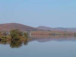
Lake Saint-Charles
| Lake Saint-Charles | |
|---|---|
 | |
| Location | Capitale-Nationale, Quebec |
| Coordinates | 46°56′28″N 71°23′14″W / 46.94111°N 71.38722°WCoordinates: 46°56′28″N 71°23′14″W / 46.94111°N 71.38722°W |
| Primary outflows | Saint-Charles River |
| Catchment area | 167.7 km2 (64.7 sq mi) |
| Basin countries | Canada |
| Surface area | 3.6 km2 (1.4 sq mi) |
| Max. depth | 16.5 m (54 ft) |
| Water volume | 14,810,000 m3 (523,000,000 cu ft) |
| Surface elevation | 150.42 m (493.5 ft) |
| Settlements | Quebec City, Stoneham-et-Tewkesbury |
| References | [1] |
Lake Saint-Charles (French: Lac Saint-Charles) is a lake located in the Capitale-Nationale region of Quebec, Canada. It is located partially within the Quebec City borough of La Haute-Saint-Charles and partially within the united township municipality of Stoneham-et-Tewkesbury. Lake Saint-Charles is the source of the Saint-Charles River. Located less than 20 minutes from downtown Quebec City, it is an important natural habitat to Quebec City area residents. Lac-Delage and the borough of Charlesbourg also administer a portion of its drainage basin.
References
- ↑ "Le lac Saint-Charles". Association pour la protection de l’environnement du lac Saint-Charles et des Marais du Nord (APEL). Retrieved 21 September 2013.
This article is issued from Wikipedia - version of the 11/22/2015. The text is available under the Creative Commons Attribution/Share Alike but additional terms may apply for the media files.