Langbathseen
| Vorderer Langbathsee | |
|---|---|
 | |
| Location | Ebensee |
| Coordinates | 47°50.1′N 13°40.87′E / 47.8350°N 13.68117°ECoordinates: 47°50.1′N 13°40.87′E / 47.8350°N 13.68117°E[1] |
| Type | Oligotrophic |
| Primary inflows | Pfrillenbach, aquifers[1] |
| Primary outflows | Langbathbach[1] |
| Catchment area | 13.8 km2 (5.3 sq mi)[1] |
| Basin countries | Austria |
| Designation | Nature reserve |
| Max. length | 1.1 km (0.68 mi)[2] |
| Max. width | 500 m (1,600 ft)[2] |
| Surface area | 0.33 km2 (0.13 sq mi)[1] |
| Max. depth | 33 m (108 ft)[1] |
| Water volume | 5,500,000 m3 (4,500 acre·ft)[1] |
| Residence time | 0.87[1] |
| Surface elevation | 664 m (2,178 ft)[1] |
| References | [1][2] |
| Hinterer Langbathsee | |
|---|---|
 | |
| Location | Ebensee |
| Coordinates | 47°49.85′N 13°39.18′E / 47.83083°N 13.65300°E[3] |
| Type | Oligotrophic |
| Primary inflows | Hirschbach, aquifers[3] |
| Primary outflows | Pfrillenbach[3] |
| Catchment area | 9.8 km2 (3.8 sq mi)[3] |
| Basin countries | Austria |
| Designation | Nature reserve |
| Max. length | 500 m (1,600 ft)[2] |
| Max. width | 400 m (1,300 ft)[2] |
| Surface area | 0.1 km2 (0.039 sq mi)[3] |
| Max. depth | 18 m (59 ft)[3] |
| Water volume | 900,000 m3 (730 acre·ft)[3] |
| Residence time | 69 days[3] |
| Surface elevation | 723 m (2,372 ft)[3] |
| References | [2][3] |
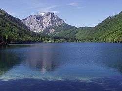
The Langbathseen are two mountain lakes (Vorderer Langbathsee and Hinterer Langbathsee) in Upper Austria's part of the Salzkammergut, 8 kilometers (5.0 mi) from Ebensee.[2] Its excellent visibility makes the Vorderer Langbathsee a popular diving site.
References
- 1 2 3 4 5 6 7 8 9 10 "Seeprofil Vorderer Langbathsee" (PDF). Amtliches-Seen-Messnetz (in German). Amt der Oberösterreichischen Landesregierung, Direktion Umwelt und Wasserwirtschaft, Abteilung Oberflächengewässerwirtschaft. July 2011. Retrieved 2012-01-18.
- 1 2 3 4 5 6 7 Pachl, W (2010-11-17). "Langbathsee". Österreich Lexikon. Verlagsgemeinschaft Österreich-Lexikon. Retrieved 2012-01-12.
- 1 2 3 4 5 6 7 8 9 10 "Seeprofil Hinterer Langbathsee" (PDF). Amtliches-Seen-Messnetz (in German). Amt der Oberösterreichischen Landesregierung, Direktion Umwelt und Wasserwirtschaft, Abteilung Oberflächengewässerwirtschaft. July 2011. Retrieved 2012-01-18.
This article is issued from Wikipedia - version of the 3/21/2013. The text is available under the Creative Commons Attribution/Share Alike but additional terms may apply for the media files.