Laram Quta (El Alto)
This article is about the lake in the El Alto Municipality, Murillo Province, La Paz Department, Bolivia. For other uses, see Laram Quta (disambiguation).
| Laram Quta | |
|---|---|
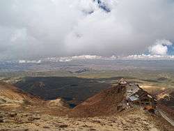 A view of Laram Quta (the largest lake) and Phaq'u Quta (in the distance) from the top of Chacaltaya. Chacaltaya refuge is on the right. | |
| Location |
Bolivia, La Paz Department, Murillo Province |
| Coordinates | 16°22′34″S 68°7′55″W / 16.37611°S 68.13194°WCoordinates: 16°22′34″S 68°7′55″W / 16.37611°S 68.13194°W |
| Max. length | 0.5 km (0.31 mi) |
| Max. width | 0.17 km (0.11 mi) |
| Surface elevation | 4,556 m (14,948 ft) |
Laram Quta[1] (Aymara larama blue, quta lake,[2] "blue lake", hispanicized spelling Laram Kkota) is a lake in Bolivia located in the La Paz Department, Pedro Domingo Murillo Province, El Alto Municipality.[3][4] It lies south of the mountain Chacaltaya, south-east of Milluni Lake, south-west of the Qillwani Lakes and north-west of Qillwani (Khelluani). Laram Quta is situated at a height of about 4,556 metres (14,948 ft), about 0,5 km long and 0,17 km at its widest point.
Gallery
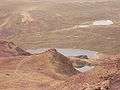 Laram Quta in the middle and Phaq'u Quta in the background as seen from the north
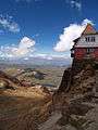 Laram Quta (the largest lake in the middle) as seen from Chacaltaya refuge
See also
References
- ↑ summitpost.org Map of the area showing "Laram Quta" north west of El Alto / La Paz
- ↑ Radio San Gabriel, "Instituto Radiofonico de Promoción Aymara" (IRPA) 1993, Republicado por Instituto de las Lenguas y Literaturas Andinas-Amazónicas (ILLLA-A) 2011, Transcripción del Vocabulario de la Lengua Aymara, P. Ludovico Bertonio 1612 (Spanish-Aymara-Aymara-Spanish dictionary)
- ↑ Bolivian IGM map 1:50,000 La Paz (Norte) 5944-I
- ↑ "El Alto". INE, Bolivia. Retrieved September 24, 2014. (unnamed)
This article is issued from Wikipedia - version of the 9/24/2014. The text is available under the Creative Commons Attribution/Share Alike but additional terms may apply for the media files.