Letychiv
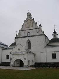
Letychiv (Ukrainian: Летичів; Polish: Latyczów; Russian: Летичев) is a town in the eastern part of Khmelnytskyi Oblast (province) of western Ukraine. 51 km from Khmelnytskyi and 33 km from the railway station Derazhnya. Administrative center since Tsarist times, formerly in Podolia Province, although now it is administratively a part of the Letychiv Raion. Population: 11,081 inhabitants (2001 census). There are brickworks, dairy, plant of construction material in the town. Located 49°23'N, 27°37'E on the main road between Khmelnitsky and Vinnytsia at the confluence of the Volk and the Southern Bug rivers.
History
Founded in 1362. First historical mention is in connection with the Tatar invasions dates to 1411. It is mentioned first as a palisade fortress, then under Magdeburg law as a settlement in 1429. Even with natural moats on all sides, Letichev did not have the topographic relief that blesses other Podilia Province strongholds (such as Medzhibozh or Kamenets Podilsky). Thus, Letychiv was more easily attacked and harder to defend. Because of this, until Tsarist times Letychiv played a subordinate role to nearby Medzhibozh.
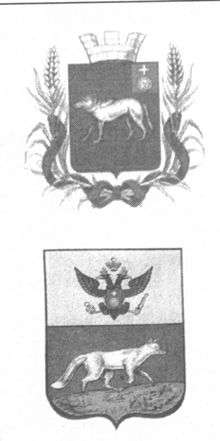
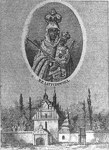
Dominican friars brought an icon of Mary, mother of Jesus to Letychiv in the late 15th century. Letychiv suffered attacks by the Tatars in 1453, 1516, 1558, and 1567. In 1546, the first Assumption church was built. In 1569, Stephan Batory presented Letychiv with its first coat of arms. It shows a wolf, representing the river Volk.
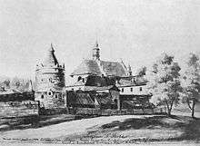
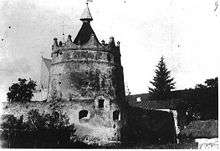
In 1598 Jan Potocki replaced the town's weaker wooden fortifications with extensive stone fortifications, known as Letychiv Fortress. Very little of these survive today, with the exception of one tower and the adjacent walls around the Assumption Church (rebuilt by Potocki in 1605).
Letychiv suffered deprivations from Bohdan Khmelnytsky's cossack uprising in 1648. During this time, Letychiv's icon was removed from the Assumption Church for safekeeping in Lviv. Weakened by the cossack uprising, Podilia was invaded and occupied by Turkey in 1672. Letychiv became part of the Turkish Ejalet of Kamieniecki. In 1682, Letychiv was recaptured by the Poles under Jan Sobiesky. However, Poles didn't regain full control until 1699 because the town was frequently ravaged by ongoing struggles between the Poles and Turks. The icon was returned to Letychiv in 1723. In 1778, Pope Clement XIV ordered that a special crown from Rome be installed on the icon. Letychiv continued to be attacked by cossacks and Haidamaks in 1702, 1734, 1737, 1749, 1750, 1755, 1768, and 1777.
In the 18th century, Letychiv had grown to be the second largest town in Podilia, Medzhibozh being the largest. The first Jews in Letychiv are reported in stories within Shivhei haBesht (stories about the Baal Shem Tov) that probably date from about 1750. By the 1780s there were approximately 800 Jews living in the town. Letychiv passed into Russian hands during the second partition of Poland in 1792. At that time, the Tsarist administrative center of this region moved from Medzhibozh to Letychiv. The population soon exploded and reached its peak in the late 19th century. Approximately 4,100 Jews lived here in 1897, about 60% of the population. In 1882 Letichiv was the scene of a notorious pogrom against Jews that resulted in a sensational trial of the pogromists.
After the 1917 Bolshevik Revolution, the territory was occupied by German and Hungarian troops until the end of World War I. Letychev was the scene of numerous pogroms during the Ukrainian Civil War of 1919-1922. The town changed hands many times as different militia units from either the Bolsheviks, Ukrainian Nationalists, Poles, or Whites gained temporary control. What little wealth was left was stripped in these pogroms turning the entire area into ruins.
Under Soviet rule starting 1922, the region's economy improved. Electricity, schools, roads and other infrastructure were built. Several kolkhozi (collective farms) were established nearby. In the early 1930s, pressure from the government to collectivize resulted in severe food shortages that resulted in famines throughout Ukraine.
In World War II, Letichiv fell to German forces during Operation Barbarossa on July 17, 1941 after heavy fighting. In that action, retreating Soviet troop blew up the dam over the river Volk over which carried the main east-west road. This temporarily stopped the German advance for nine days until the position could be outflanked from the south. It remained in German hands until it was liberated by Soviet troops on March 23, 1944.
Letychiv was astride an important east-west supply road that the German government wanted to expand into an autobahn-like highway. This road led directly between the city of Proskuriv and routes westward into Germany and the city of Vinnytsia with routes to the eastern front. Vinnytsia was the site of Hitler's headquarters bunker in Soviet territory where he personally directed the war between 1942 and 1943.
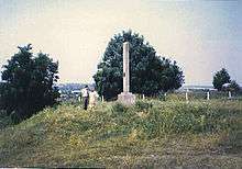
A Jewish ghetto and a separate slave labor camp within Letychiv Castle was established in Letychiv to assist Organisation Todt in providing human labor for the road building project. Because of this special road project, Letychiv retained its Jews longer than most of the surrounding communities, where Einsatzgruppen units executed entire populations of Jews shortly after German occupation. However, when the road project was completed in the summer of 1942, the Einsatzgruppen units were called in. Three separate mass shootings of Jews occurred in September 1942 where 3,000 Jews were killed (half the ghetto), in November 1942 where 4,000 Jews were killed (the remainder of the ghetto), and in November 1943 where the remaining 200 Jews in the slave labor camp were shot. That eliminated all Jews from the town. Soviet authorities reported that a total of 7,200 Jews were murdered in a ravine in Zaletichevka, just south of town.
Famous people
- Ustym Karmaliuk (1787–1835), a notorious thief and gang leader, is considered a Ukrainian Robin Hood and folk hero. He principally robbed from rich nobles and distributed the wealth to peasants. He is buried in the Letychiv Cemetery. A statue to his memory is located there.
- Morris Zimmerman (1876–1959), immigrated to the US from Letychiv in 1903 and became an important craftsman, merchant and businessman in Baltimore, Md.
- Oscar Williams (1900–1964), a noted American poet, was born in Letychiv to Jewish parents.
- Rabbi Samuel M. Blumenfield (1901–1972), a noted American rabbi, was born in Letychiv and immigrated to the US in 1919.
- Joseph "Doc" Stacher (1902–1977), from the Letychiv Oystacher family, was a notorious Jewish crime boss who immigrated to the U.S. and later to Israel. He had close connections with the Jewish Mafia of Meyer Lansky and Bugsy Siegel (whose parents Max Siegel and Jennie Goldstein Siegel came from Letychiv).
- David H. Kurtzman, Ph.D. (1904–1977), a noted American academician, immigrated from Letychiv in 1921.
- Mitchell S. Gordon (1911–1982), born in Letychiv son of Samuel and Susan Goldstein, his father was killed in Russia during the revolution. Immigrated to the US in the 1920s. He received his Doctorate in Optometry and was instrumental in the development of plastic artificial eyes. In the late 1950s he began new careers as a comedian, hypnotist, graphologist, journalist, stage and screen actor, magician, musician, artist and a characterist. He went under the names of Farouk, 'Doc', Mitchell, and Mizgor Mitchell. He appeared with Jerry Lewis and Henny Youngman.
- Naum Davydovych Morgulis, Ph.D. (1904–1976), born in Letychiv, he was a noted Ukrainian physicist and electrical engineer. He founded and chaired the department of electophysics and physical electronics at Institute of Physics in the Ukrainian Academy of Sciences in Kiev. Was known for his research into cathodes and photocells. He was a mentor to a large number of Ukrainian and Russian physicists and academians.[1]
Bibliography
- Chapin, David A. and Weinstock, Ben, The Road from Letichev: The history and culture of a forgotten Jewish community in Eastern Europe, Volume 1. ISBN 0-595-00666-3 iUniverse, Lincoln, NE, 2000.
- Chapin, David A. and Weinstock, Ben, The Road from Letichev: The history and culture of a forgotten Jewish community in Eastern Europe, Volume 2. ISBN 0-595-00667-1 iUniverse, Lincoln, NE, 2000.
External links
- Road from Letychiv. Book by David Chapin and Ben Weinstock
- Road from Letychiv - online reading version
- Article on Letychiv (Polish)
- The murder of the Jews of Letychiv during World War II, at Yad Vashem website.
References
- ↑ Memorium for Morgulis (English)
Coordinates: 49°23′N 27°37′E / 49.383°N 27.617°E