Lindolfo Collor, Rio Grande do Sul
| Lindolfo Collor | |||
|---|---|---|---|
| Municipality | |||
| |||
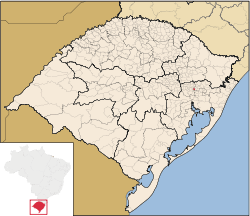
 Location within Rio Grande do Sul | |||
 Lindolfo Collor Location in Brazil | |||
| Coordinates: 29°35′49″S 51°12′32″W / 29.59694°S 51.20889°WCoordinates: 29°35′49″S 51°12′32″W / 29.59694°S 51.20889°W | |||
| Country |
| ||
| State | Rio Grande do Sul | ||
| Founded | March 26, 1992 | ||
| Government | |||
| • Mayor | Alceu Ricardo Heinle (PMDB) | ||
| Area | |||
| • Total | 32.99 km2 (12.74 sq mi) | ||
| Elevation | 37 m (121 ft) | ||
| Population (2015) | |||
| • Total | 5,671 | ||
| • Density | 170/km2 (450/sq mi) | ||
| Time zone | BRT (UTC-3) | ||
| • Summer (DST) | BRST (UTC-2) | ||
| Postal code | 93900 | ||
| Area code | (+55) 51 | ||
Lindolfo Collor is a municipality in the state Rio Grande do Sul, Brazil. It is named after the Minister of Labor during the Estado Novo. The population is 5,671 (2015 est.) in an area of 32.99 km².[1]
History
Lindolfo Collor was first colonized by German immigrants to Brazil. It was originally known as "Picada Capivara," a reference to the numerous capybaras in the region. When the town was incorporated the name "Lindolfo Collor" was adopted to honor the former Minister of Labor.
Health
A study by the Instituto de Pesquisa Econômica Aplicada (Ipea), released in June 2008, named Lindolfo Collor as the second best city in Brazil in terms of public health. The study compared mortality rates and life expectancy between 1991 and 2000.[2]
References
- ↑ Instituto Brasileiro de Geografia e Estatística
- ↑ Zero Hora. "Reportagem: Saúde de Lindolfo Collor entre as 10 melhores do Brasil". Retrieved 22 June 2008.
See also
This article is issued from Wikipedia - version of the 5/15/2016. The text is available under the Creative Commons Attribution/Share Alike but additional terms may apply for the media files.


