List of listed buildings in Gigha And Cara, Argyll and Bute
This is a list of listed buildings in the parish of Gigha And Cara in Argyll and Bute, Scotland.
List
| Name | Location | Date Listed | Grid Ref. [note 1] | Geo-coordinates | Notes | HB Number [note 2] | Image |
|---|---|---|---|---|---|---|---|
| Achamore House | Gigha | 20/07/1971 | 55°40′01″N 5°45′00″W / 55.666909°N 5.749885°W | Category B | 11449 | 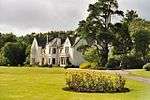
| |
| Achamore Farm-House And Steading | 55°39′52″N 5°45′13″W / 55.664349°N 5.753617°W | Category B | 11426 | 
| |||
| Cara Chapel (St. Finla's) | 55°38′06″N 5°44′59″W / 55.635065°N 5.749652°W | Category B | 11430 |
| |||
| Boundary Wall (With 2 Gate-Ways), Kilchattan Burial Ground | Gigha | 28/08/1980 | 55°40′08″N 5°44′57″W / 55.668853°N 5.749228°W | Category C(S) | 11448 | 
| |
| Gigha Hotel Ardmenish | Ardminish | 20/07/1971 | 55°40′29″N 5°44′29″W / 55.674599°N 5.741297°W | Category B | 11446 | 
| |
| Gigha And Cara Parish Church, Cnocan A Chiuil, Ardmenish | 55°40′37″N 5°44′34″W / 55.676857°N 5.742738°W | Category B | 13759 |
| |||
| Gate-Lodge (With Gate-Piers And Garden Walls) Achamore Estate, Main Road | 55°39′40″N 5°45′02″W / 55.661134°N 5.750541°W | Category B | 11425 |
| |||
| Cara House | 55°38′06″N 5°44′57″W / 55.635108°N 5.749147°W | Category C(S) | 11429 | 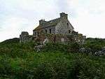
| |||
| Kilchattan Chapel (St Catan's) Kilchattan Burial Ground | 55°40′08″N 5°44′58″W / 55.668993°N 5.749352°W | Category B | 11447 |
| |||
| Gate-Way, Achamore Estate, Main Road | 55°39′59″N 5°44′43″W / 55.666351°N 5.745186°W | Category B | 11450 |
| |||
| Gigha And Cara Manse, Ardmenish | 55°40′38″N 5°44′21″W / 55.677338°N 5.73906°W | Category B | 11427 |
| |||
| Old Water-Mill, Port An Duin | 55°41′31″N 5°45′15″W / 55.691864°N 5.754234°W | Category C(S) | 11428 |
|
Key
The scheme for classifying buildings in Scotland is:
- Category A: "buildings of national or international importance, either architectural or historic, or fine little-altered examples of some particular period, style or building type."[1]
- Category B: "buildings of regional or more than local importance, or major examples of some particular period, style or building type which may have been altered."[1]
- Category C(S): "buildings of local importance, lesser examples of any period, style, or building type, as originally constructed or moderately altered; and simple traditional buildings which group well with others in categories A and B."[1]
There are approximately 47,400 listed buildings in Scotland. Of these, around 8 per cent (some 3,800) are Category A, and 51 per cent (24,000) are Category B, with the rest listed at Category C(s).[2]
See also
Notes
- ↑ Sometimes known as OSGB36, the grid reference (where provided) is based on the British national grid reference system used by the Ordnance Survey.
• "Guide to National Grid". Ordnance Survey. Retrieved 2007-12-12.
• "Get-a-map". Ordnance Survey. Retrieved 2007-12-17. - ↑ The "HB Number" is a unique number assigned to each listed building by Historic Scotland.
References
- All entries, addresses and coordinates are based on data from Historic Scotland. This data falls under the Open Government Licence
- 1 2 3 "What is Listing?". Historic Scotland. Retrieved 2010-07-06.
- ↑ Guide to the Protection of Scotland’s Listed Buildings (PDF). Historic Scotland. 2009. p. 17. ISBN 978-1-84917-013-0. Retrieved 2010-07-06.
This article is issued from Wikipedia - version of the 10/15/2016. The text is available under the Creative Commons Attribution/Share Alike but additional terms may apply for the media files.