List of listed buildings in Kildalton And Oa, Argyll and Bute
This is a list of listed buildings in the parish of Kildalton And Oa in Argyll and Bute, Scotland.
List
| Name | Location | Date Listed | Grid Ref. [note 1] | Geo-coordinates | Notes | HB Number [note 2] | Image |
|---|---|---|---|---|---|---|---|
| 31-35 School Street | 55°37′46″N 6°11′21″W / 55.629491°N 6.189207°W | Category C(S) | 11970 | 
| |||
| Port Ellen Distillery | 55°38′00″N 6°11′47″W / 55.633243°N 6.196508°W | Category B | 11971 |
| |||
| St. Nechtan's Chapel Kilnaughton Burial Ground | 55°37′40″N 6°13′14″W / 55.62784°N 6.220522°W | Category B | 11974 |
| |||
| Port Ellen Village Houses, Near Old Battery 144 (Texa House) And 145 Frederick Crescent | 55°37′34″N 6°11′14″W / 55.62608°N 6.187174°W | Category C(S) | 12002 |
| |||
| Kildalton Small Cross Outside Kildalton Burial Ground | 55°41′04″N 6°02′42″W / 55.68451°N 6.045059°W | Category B | 11999 | .jpg)
| |||
| Ardtalla Farmhouse And Steading | 55°43′05″N 6°02′09″W / 55.718045°N 6.035816°W | Category C(S) | 12000 |
| |||
| Loch Laphroaig, Laphroaig Distillery | 55°37′46″N 6°09′07″W / 55.629454°N 6.151988°W | Category C(S) | 12435 |
| |||
| Ardview Hotel, Frederick Crescent | 55°37′48″N 6°11′09″W / 55.629887°N 6.185768°W | Category C(S) | 11969 |
| |||
| Port Ellen Lighthouse, Carraig Fhada | 55°37′13″N 6°12′42″W / 55.620227°N 6.211756°W | Category B | 11973 |
| |||
| Kidalton Castle | 55°39′12″N 6°04′34″W / 55.653434°N 6.076127°W | Category C(S) | 12001 |
| |||
| Islay, Port Ellen, Frederick Street, St John's Parish Church Including Boundary Walls | 55°37′40″N 6°10′59″W / 55.627887°N 6.182979°W | Category B | 49190 |
| |||
| The Oa Church, Risabus | 55°36′43″N 6°16′00″W / 55.611986°N 6.266631°W | Category C(S) | 11972 |
| |||
| 'The Grange' (Former Old U.F. Manse) | 55°37′51″N 6°10′53″W / 55.630931°N 6.181269°W | Category C(S) | 12003 |
| |||
| Kildalton Chapel Kidalton Burial Ground | 55°41′03″N 6°02′44″W / 55.684162°N 6.045517°W | Category B | 13797 | 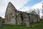
| |||
| Texa Chapel | 55°37′04″N 6°08′43″W / 55.6179°N 6.145282°W | Category B | 11975 |
|
Key
The scheme for classifying buildings in Scotland is:
- Category A: "buildings of national or international importance, either architectural or historic, or fine little-altered examples of some particular period, style or building type."[1]
- Category B: "buildings of regional or more than local importance, or major examples of some particular period, style or building type which may have been altered."[1]
- Category C(S): "buildings of local importance, lesser examples of any period, style, or building type, as originally constructed or moderately altered; and simple traditional buildings which group well with others in categories A and B."[1]
There are approximately 47,400 listed buildings in Scotland. Of these, around 8 per cent (some 3,800) are Category A, and 51 per cent (24,000) are Category B, with the rest listed at Category C(s).[2]
See also
Notes
- ↑ Sometimes known as OSGB36, the grid reference (where provided) is based on the British national grid reference system used by the Ordnance Survey.
• "Guide to National Grid". Ordnance Survey. Retrieved 2007-12-12.
• "Get-a-map". Ordnance Survey. Retrieved 2007-12-17. - ↑ The "HB Number" is a unique number assigned to each listed building by Historic Scotland.
References
- All entries, addresses and coordinates are based on data from Historic Scotland. This data falls under the Open Government Licence
- 1 2 3 "What is Listing?". Historic Scotland. Retrieved 2010-07-06.
- ↑ Guide to the Protection of Scotland’s Listed Buildings (PDF). Historic Scotland. 2009. p. 17. ISBN 978-1-84917-013-0. Retrieved 2010-07-06.
This article is issued from Wikipedia - version of the 10/15/2016. The text is available under the Creative Commons Attribution/Share Alike but additional terms may apply for the media files.