List of listed buildings in Rafford, Moray
This is a list of listed buildings in the parish of Rafford in Moray, Scotland.
List
| Name | Location | Date Listed | Grid Ref. [note 1] | Geo-coordinates | Notes | HB Number [note 2] | Image |
|---|---|---|---|---|---|---|---|
| Altyre, Blairs Home Farm With Tower Cottages, Pond Cottage And Clubhouse | 57°34′32″N 3°37′37″W / 57.575659°N 3.627069°W | Category A | 17429 | 
| |||
| Altyre, Blairs Cottage | 57°34′35″N 3°37′29″W / 57.576498°N 3.624732°W | Category C(S) | 17430 |
| |||
| Altyre, Wardend Cottages | 57°34′29″N 3°36′12″W / 57.574831°N 3.603319°W | Category C(S) | 15579 |
| |||
| Altyre, Blairs Home Farm, Grieve's Cottage (The Bungalow) | 57°34′37″N 3°37′38″W / 57.57705°N 3.627215°W | Category B | 15596 |
| |||
| Altyre, East Lodge (Formerly Wardend Lodge) | 57°34′52″N 3°36′21″W / 57.581036°N 3.6057°W | Category B | 15597 |
| |||
| Altyre, 1-8 (Inclusive Nos), Foresters' Cottages (Cothall Cottages) | 57°34′24″N 3°38′19″W / 57.573298°N 3.638736°W | Category A | 15599 |
| |||
| Altyre, Old Church | 57°34′41″N 3°36′51″W / 57.578162°N 3.614069°W | Category A | 15604 | [[File: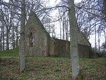 Altyre, Old Church | |||
| Altyre, West Lodge And Gates With Gatepiers | 57°34′14″N 3°38′19″W / 57.570424°N 3.638673°W | Category B | 15580 |
| |||
| Altyre, Episcopal Church | 57°34′30″N 3°37′50″W / 57.574887°N 3.630513°W | Category C(S) | 15598 | 
| |||
| Altyre, By Stables, Generator House | 57°34′18″N 3°36′42″W / 57.571644°N 3.611623°W | Category B | 15608 |
| |||
| Burgie, Walled Garden And Portico | 57°36′52″N 3°31′04″W / 57.614357°N 3.517742°W | Category B | 17431 |
| |||
| Altyre House (Formerly Blairs House) | 57°34′28″N 3°37′39″W / 57.57436°N 3.627462°W | Category B | 15577 |
| |||
| Burgie Tower | 57°36′53″N 3°31′07″W / 57.614668°N 3.518726°W | Category A | 15586 |
| |||
| Altyre, Stables | 57°34′18″N 3°36′43″W / 57.571666°N 3.612026°W | Category A | 15607 |
| |||
| Burgie House | 57°36′58″N 3°31′28″W / 57.616145°N 3.524446°W | Category B | 15584 |
| |||
| Altyre, Kennels And Kennels Cottage (Keeper's House) | 57°33′58″N 3°37′08″W / 57.566125°N 3.618886°W | Category C(S) | 15602 |
| |||
| Altyre, Office Cottages (Former School) | 57°34′39″N 3°37′18″W / 57.577401°N 3.621561°W | Category B | 15603 |
| |||
| Altyre, Walled Garden (Old Walled Garden) | 57°34′16″N 3°36′57″W / 57.571096°N 3.615829°W | Category C(S) | 15578 |
| |||
| Blervie House [1] And Gatepiers | 57°34′42″N 3°34′11″W / 57.578237°N 3.56962°W[2] And Gatepiers) | Category B | 15581 |
| |||
| Blervie Tower | 57°35′42″N 3°33′22″W / 57.595023°N 3.556172°W | Category A | 15583 |
| |||
| Altyre, 1 Gardeners' Cottages | 57°34′26″N 3°36′55″W / 57.573951°N 3.615304°W | Category B | 15600 |
| |||
| Altyre, Old Stable Tower | 57°34′08″N 3°36′55″W / 57.568784°N 3.615393°W | Category C(S) | 15605 |
| |||
| Burgie Lodge | 57°37′14″N 3°31′39″W / 57.620419°N 3.527539°W | Category B | 15587 |
| |||
| Rafford Burial Ground | 57°35′09″N 3°34′26″W / 57.585775°N 3.573909°W | Category B | 15590 |
| |||
| Altyre, Scurrypool Bridge Over The Altyre Burn And Disused Railway | 57°33′33″N 3°36′07″W / 57.559126°N 3.602027°W | Category B | 15606 |
| |||
| Burgie House, Dovecot | 57°36′52″N 3°31′10″W / 57.614526°N 3.51934°W | Category B | 15585 |
| |||
| Marcassie Farmhouse | 57°35′23″N 3°34′47″W / 57.589619°N 3.579763°W | Category B | 15588 |
| |||
| Rongai House (Former Rafford Church Of Scotland Manse) And Steading | 57°35′11″N 3°34′17″W / 57.586257°N 3.571304°W | Category B | 15591 |
| |||
| Blervie Mains House | 57°35′38″N 3°34′13″W / 57.593816°N 3.570291°W | Category A | 15582 |
| |||
| Rafford Parish Church (Church Of Scotland) | 57°35′15″N 3°34′25″W / 57.587613°N 3.573487°W | Category B | 15589 |
| |||
| Altyre, 2 Gardeners' Cottages | 57°34′26″N 3°36′56″W / 57.573884°N 3.615568°W | Category B | 15601 |
|
Key
The scheme for classifying buildings in Scotland is:
- Category A: "buildings of national or international importance, either architectural or historic, or fine little-altered examples of some particular period, style or building type."[3]
- Category B: "buildings of regional or more than local importance, or major examples of some particular period, style or building type which may have been altered."[3]
- Category C(S): "buildings of local importance, lesser examples of any period, style, or building type, as originally constructed or moderately altered; and simple traditional buildings which group well with others in categories A and B."[3]
There are approximately 47,400 listed buildings in Scotland. Of these, around 8 per cent (some 3,800) are Category A, and 51 per cent (24,000) are Category B, with the rest listed at Category C(s).[4]
See also
Notes
- ↑ Sometimes known as OSGB36, the grid reference (where provided) is based on the British national grid reference system used by the Ordnance Survey.
• "Guide to National Grid". Ordnance Survey. Retrieved 2007-12-12.
• "Get-a-map". Ordnance Survey. Retrieved 2007-12-17. - ↑ The "HB Number" is a unique number assigned to each listed building by Historic Scotland.
References
- All entries, addresses and coordinates are based on data from Historic Scotland. This data falls under the Open Government Licence
- ↑ "Blervie House" (PDF).
- ↑ "Blervie House" (PDF).
- 1 2 3 "What is Listing?". Historic Scotland. Retrieved 2010-07-06.
- ↑ Guide to the Protection of Scotland’s Listed Buildings (PDF). Historic Scotland. 2009. p. 17. ISBN 978-1-84917-013-0. Retrieved 2010-07-06.
This article is issued from Wikipedia - version of the 10/15/2016. The text is available under the Creative Commons Attribution/Share Alike but additional terms may apply for the media files.