List of listed buildings in South Uist
This is a list of listed buildings in the parish of South Uist in the Outer Hebrides, Scotland.
List
| Name | Location | Date Listed | Grid Ref. [note 1] | Geo-coordinates | Notes | HB Number [note 2] | Image |
|---|---|---|---|---|---|---|---|
| South Lochboisdale Boisdale House And Post Office | 57°08′13″N 7°20′18″W / 57.136927°N 7.33829°W | Category B | 18743 | 
| |||
| South Smerclate (Thatched Cottage At O.S. Grid Reference Nf 743 153) | 57°06′49″N 7°22′53″W / 57.113685°N 7.381468°W | Category B | 18747 |
| |||
| Benbecula, 1 Kyles Flodda | 57°29′04″N 7°17′49″W / 57.484558°N 7.296886°W | Category B | 18752 |
| |||
| Benbecula Hacklet 1 Aird Cumhang | 57°24′38″N 7°16′40″W / 57.410613°N 7.277891°W | Category B | 18755 |
| |||
| Benbecula 9 Liniclate | 57°25′20″N 7°20′46″W / 57.422176°N 7.34623°W | Category B | 18757 |
| |||
| Benbecula 10, Uachdar | 57°26′50″N 7°20′06″W / 57.447277°N 7.334946°W | Category C(S) | 18760 |
| |||
| Bornish House | 57°14′39″N 7°24′46″W / 57.244116°N 7.41275°W | Category C(S) | 18761 |
| |||
| Daliburgh Church Of Scotland And Manse | 57°10′05″N 7°22′27″W / 57.167959°N 7.374183°W | Category B | 18763 |
| |||
| Daliburgh St Peters R.C. Church | 57°09′53″N 7°23′12″W / 57.164709°N 7.386779°W | Category C(S) | 18764 |
| |||
| North Smerclate Cottage Byre And Outbuildings | 57°06′58″N 7°22′00″W / 57.116073°N 7.36653°W | Category B | 18777 |
| |||
| Rhughasinish John Mackillop | 57°22′49″N 7°17′25″W / 57.380402°N 7.290349°W | Category B | 18741 |
| |||
| West Kilbride Walled Garden (Beside Site Of Kilbride House) | 57°06′13″N 7°21′20″W / 57.103517°N 7.355681°W | Category C(S) | 18750 |
| |||
| Benbecula Hacklet Kilerivagh (Thatched Cottage At O.S. Grid Reference Nf 825 482) | 57°24′47″N 7°17′18″W / 57.413046°N 7.288297°W | Category C(S) | 18756 |
| |||
| Benbecula 1, 2 & 3 Nunton House Outbuildings And Gatepiers | 57°27′23″N 7°23′49″W / 57.456283°N 7.396987°W | Category B | 18758 |
| |||
| Drimore Farmhouse And Steading | 57°20′16″N 7°22′23″W / 57.337839°N 7.373145°W | Category B | 18766 |
| |||
| Eochar 77 Ardmanonie Cottage And Outbuildings | 57°23′26″N 7°22′24″W / 57.390668°N 7.373279°W | Category A | 18767 |
| |||
| Howmore Parish Church And Churchyard Walls | 57°18′09″N 7°23′16″W / 57.30263°N 7.387698°W | Category B | 18771 |
| |||
| 153 Howmore | 57°18′07″N 7°23′02″W / 57.301999°N 7.383964°W | Category B | 18772 |
| |||
| Ardkenneth St Michael's Church Presbytery & Gatepiers | 57°23′15″N 7°23′49″W / 57.387577°N 7.39689°W | Category B | 18779 |
| |||
| Our Lady Of The Isles Statue, Ben Reuval | 57°20′34″N 7°21′39″W / 57.342727°N 7.360695°W | Category B | 50888 | 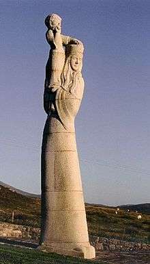
| |||
| Lochboisdale, School And School House With Garden And Boundary Walls And Gatepiers | 57°09′17″N 7°18′37″W / 57.154738°N 7.310344°W | Category C(S) | 44722 |
| |||
| Benbecula, Nunton Steadings | 57°27′28″N 7°23′47″W / 57.457776°N 7.396389°W | Category B | 43387 |
| |||
| Pollacher Inn | 57°06′19″N 7°22′32″W / 57.105197°N 7.375438°W | Category B | 18739 |
| |||
| 472 South Lochboisdale And Byre And Shed (Campbell) | 57°08′07″N 7°18′57″W / 57.1354°N 7.315826°W | Category A | 18746 |
| |||
| West Kilbride Byre (At O.S. Grid Reference Nf 755 145) (Alasdair Walker) | 57°06′24″N 7°21′42″W / 57.106541°N 7.361758°W | Category B | 18751 |
| |||
| Daliburgh (Thatched Cottage At O.S. Grid Reference Nf 741210) | 57°09′52″N 7°23′32″W / 57.164523°N 7.392334°W | Category B | 18765 |
| |||
| Rhughasinish Flora Macleod | 57°22′57″N 7°16′55″W / 57.382409°N 7.282024°W | Category B | 19907 |
| |||
| Eochar 51 Balgarva | 57°23′47″N 7°22′54″W / 57.396297°N 7.381789°W | Category B | 18769 |
| |||
| Eriskay St Michael's R.C. Church | 57°05′13″N 7°18′24″W / 57.086885°N 7.306748°W | Category C(S) | 18770 |
| |||
| 429 North Lochboisdale | 57°09′44″N 7°19′28″W / 57.162181°N 7.324499°W | Category A | 18776 |
| |||
| Garrynamonie, Our Lady Of Sorrows Rc Church Including Boundary Walls And Gatepiers | 57°07′28″N 7°21′33″W / 57.124508°N 7.359133°W | Category B | 51401 |
| |||
| Eochar Bualadubh Mrs Johnstone (Cottage To North Of Former Museum) | 57°23′32″N 7°20′53″W / 57.392093°N 7.34812°W | Category A | 19908 |
| |||
| Benbecula 5, 6 Hacklet | 57°24′43″N 7°18′16″W / 57.41191°N 7.304358°W | Category B | 18754 |
| |||
| 99 Carnan | 57°24′04″N 7°20′45″W / 57.401185°N 7.345731°W | Category B | 18762 |
| |||
| Eochar 96 Bualadubh | 57°23′31″N 7°21′23″W / 57.392041°N 7.356313°W | Category B | 18768 |
| |||
| North Boisdale Burial Ground | 57°07′52″N 7°23′45″W / 57.131089°N 7.395915°W | Category B | 18774 |
| |||
| Askernish House, Garden Walls And Gatepiers | 57°11′22″N 7°24′23″W / 57.189346°N 7.406255°W | Category B | 18780 |
| |||
| Ormaclett House Beside Former Clanranald Mansion | 57°15′37″N 7°24′33″W / 57.260274°N 7.409114°W | Category C(S) | 18738 |
| |||
| 7 West Gerinish | 57°21′09″N 7°21′48″W / 57.352509°N 7.363224°W | Category B | 18749 |
| |||
| Benbecula Griminish Church Of Scotland & Manse | 57°26′40″N 7°20′08″W / 57.444384°N 7.335692°W | Category C(S) | 18753 |
| |||
| Benbecula Nunton Former Chapel & Cemetery Enclosure | 57°27′32″N 7°23′40″W / 57.458818°N 7.394339°W | Category B | 18759 |
| |||
| 323 North Boisdale | 57°08′16″N 7°23′14″W / 57.137857°N 7.387352°W | Category B | 18775 |
| |||
| Ormaclett Castle And Forecourt Wall (Clanranald Mansion) | 57°15′37″N 7°24′33″W / 57.260274°N 7.409114°W | Category B | 18778 |
| |||
| Isle Of South Uist, Iochdar Church Including Boundary Walls And Gatepiers | 57°23′33″N 7°20′58″W / 57.392472°N 7.349576°W | Category C(S) | 48278 |
| |||
| 11 Rhughasinish | 57°23′08″N 7°17′55″W / 57.385647°N 7.298721°W | Category B | 18740 |
| |||
| 374 South Boisdale | 57°07′38″N 7°22′52″W / 57.127302°N 7.381049°W | Category C(S) | 18742 |
| |||
| 466 South Lochboisdale | 57°08′09″N 7°18′43″W / 57.135807°N 7.311978°W | Category B | 18744 |
| |||
| 472 South Lochboisdale | 57°08′05″N 7°18′53″W / 57.134654°N 7.314742°W | Category B | 18745 |
| |||
| Staoligarry Thatched Cottage (N.C.C. Office) (Property Of No 135) | 57°19′23″N 7°22′09″W / 57.323058°N 7.369036°W | Category B | 18748 |
|
Key
The scheme for classifying buildings in Scotland is:
- Category A: "buildings of national or international importance, either architectural or historic, or fine little-altered examples of some particular period, style or building type."[1]
- Category B: "buildings of regional or more than local importance, or major examples of some particular period, style or building type which may have been altered."[1]
- Category C(S): "buildings of local importance, lesser examples of any period, style, or building type, as originally constructed or moderately altered; and simple traditional buildings which group well with others in categories A and B."[1]
There are approximately 47,400 listed buildings in Scotland. Of these, around 8 per cent (some 3,800) are Category A, and 51 per cent (24,000) are Category B, with the rest listed at Category C(s).[2]
See also
Notes
- ↑ Sometimes known as OSGB36, the grid reference (where provided) is based on the British national grid reference system used by the Ordnance Survey.
• "Guide to National Grid". Ordnance Survey. Retrieved 2007-12-12.
• "Get-a-map". Ordnance Survey. Retrieved 2007-12-17. - ↑ The "HB Number" is a unique number assigned to each listed building by Historic Scotland.
References
- All entries, addresses and coordinates are based on data from Historic Scotland. This data falls under the Open Government Licence
- 1 2 3 "What is Listing?". Historic Scotland. Retrieved 2010-07-06.
- ↑ Guide to the Protection of Scotland’s Listed Buildings (PDF). Historic Scotland. 2009. p. 17. ISBN 978-1-84917-013-0. Retrieved 2010-07-06.
This article is issued from Wikipedia - version of the 10/15/2016. The text is available under the Creative Commons Attribution/Share Alike but additional terms may apply for the media files.