Longstone Rath
| Ráth na Cloiche Fada | |
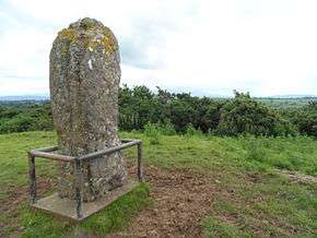 Longstone viewed in situ. | |
 Shown within Ireland | |
| Location | Longstone, Cullen, County Tipperary, Ireland |
|---|---|
| Region | Munster |
| Coordinates | 52°30′22″N 8°17′52″W / 52.506051°N 8.297753°WCoordinates: 52°30′22″N 8°17′52″W / 52.506051°N 8.297753°W |
| Area | 2,400 m2 (0.6 acre) |
| Diameter | 55 m (60 yd) |
| History | |
| Material | earth, limestone |
| Founded | 1 AD |
| Periods | Iron Age |
| Site notes | |
| Excavation dates | 1973–76 |
| Designation | National Monument |
Longstone Rath (Irish: Ráth na Cloiche Fada) is a ringfort (rath) and National Monument located in County Tipperary, Ireland.
Location
Longstone Rath is located on a height overlooking the Barna–Emly road, 1.6 km (1 mile) west-southwest of Cullen.
History and archaeology
The longstone, a lump of limestone about 2.3 m (7' 7") in height, is located on a mound within a bivallate ringfort.[1] The site was excavated in 1973–76, where 4,000 potsherds, 6 complete vessels, over 400 flint scrapers, cremated bones and grooved ware pottery were found. The mound is thought to date from c. AD 1 (mid-Iron Age, with the rath being added about AD 600.[2][3][4] According to Prof. Peter Danaher, Carrowkeel-style bowls from the complex site at Longstone seem to indicate a transitory camp of passage-tomb folk, and the hilltop was also used by Beaker, Food Vessel and Urn peoples, indicating that the site was a "halting site" for many thousands of years before the longstone and rath were made.[5]