Louisiana Highway 442
| ||||
|---|---|---|---|---|
 | ||||
| Route information | ||||
| Maintained by Louisiana DOTD | ||||
| Length: | 23.0 mi[1] (37.0 km) | |||
| Major junctions | ||||
| West end: |
| |||
|
| ||||
| East end: |
| |||
| Location | ||||
| Parishes: | Livingston, Tangipahoa | |||
| Highway system | ||||
| ||||
.svg.png)
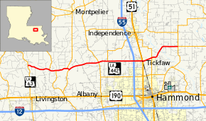
Louisiana Highway 442 (LA 442) is a state highway in Louisiana that serves Livingston and Tangipahoa parishes. It spans 23.0 miles (37.0 km) in a west to east direction.
Route description
From the west, LA 442 begins at an intersection with LA 63 north of Livingston. It heads east and intersects LA 1036 and LA 441, both of which it overlaps as it crosses various branches of the Tickfaw River. Further east, it intersects LA 43 and LA 1063 before crossing into Tangipahoa Parish. Just west of Tickfaw, LA 442 meets Interstate 55 at a diamond interchange (exit 36) and shortly thereafter, it enters Tickfaw corporate limits and reaches U.S. Route 51. After a southward jog of one block along US 51, LA 442 heads east again and bridges Ponchatoula Creek and intersects LA 1065 before bridging the Tangipahoa River. It ends shortly afterward at an intersection with LA 40 and LA 443 south of Loranger.
LA 442 is an undivided, two lane highway for its entire length.
Junction list
| Parish | Location | mi[1] | km | Destinations | Notes |
|---|---|---|---|---|---|
| Livingston | | 0.0 | 0.0 | ||
| Magnolia | 3.2 | 5.1 | West end of LA 1036 overlap | ||
| 4.2 | 6.8 | East end of LA 1036 overlap | |||
| Starns | 5.9 | 9.5 | West end of LA 441 overlap | ||
| 6.2 | 10.0 | East end of LA 441 overlap | |||
| | 10.6 | 17.1 | |||
| Tangipahoa | | 12.0 | 19.3 | Southern terminus of LA 1063 | |
| | 15.5– 15.9 | 24.9– 25.6 | Exit 36 (I-55) | ||
| Tickfaw | 16.9 | 27.2 | West end of US 51 overlap | ||
| 17.0 | 27.4 | East end of US 51 overlap | |||
| | 18.4 | 29.6 | |||
| | 23.0 | 37.0 | Northern terminus of LA 443 | ||
1.000 mi = 1.609 km; 1.000 km = 0.621 mi
| |||||
References
- 1 2 Google (February 15, 2015). "Louisiana Highway 442" (Map). Google Maps. Google. Retrieved February 15, 2015.