Lystad Bay
Lystad Bay
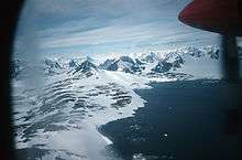
Lystad Bay (67°50′S 67°17′W / 67.833°S 67.283°WCoordinates: 67°50′S 67°17′W / 67.833°S 67.283°W) is a bay 2.5 nautical miles (5 km) wide which indents the west side of Horseshoe Island, in the northeast part of Marguerite Bay, Antarctica. It was first surveyed in 1936–37 by the British Graham Land Expedition under John Rymill, and was visited by the USMS North Star and USS Bear of the United States Antarctic Service in 1940. The name was proposed by the Advisory Committee on Antarctic Names for Captain Isak Lystad of the North Star.[1]
References
- ↑ "Lystad Bay". Geographic Names Information System. United States Geological Survey. Retrieved 2013-07-12.
![]() This article incorporates public domain material from the United States Geological Survey document "Lystad Bay" (content from the Geographic Names Information System).
This article incorporates public domain material from the United States Geological Survey document "Lystad Bay" (content from the Geographic Names Information System).
This article is issued from Wikipedia - version of the 11/21/2015. The text is available under the Creative Commons Attribution/Share Alike but additional terms may apply for the media files.